1804 Direccion Hidrografica Nautical Chart or Map of the Virgin Islands
VirginIslands-direccionhidrografica-1804-2$2,000.00


Title
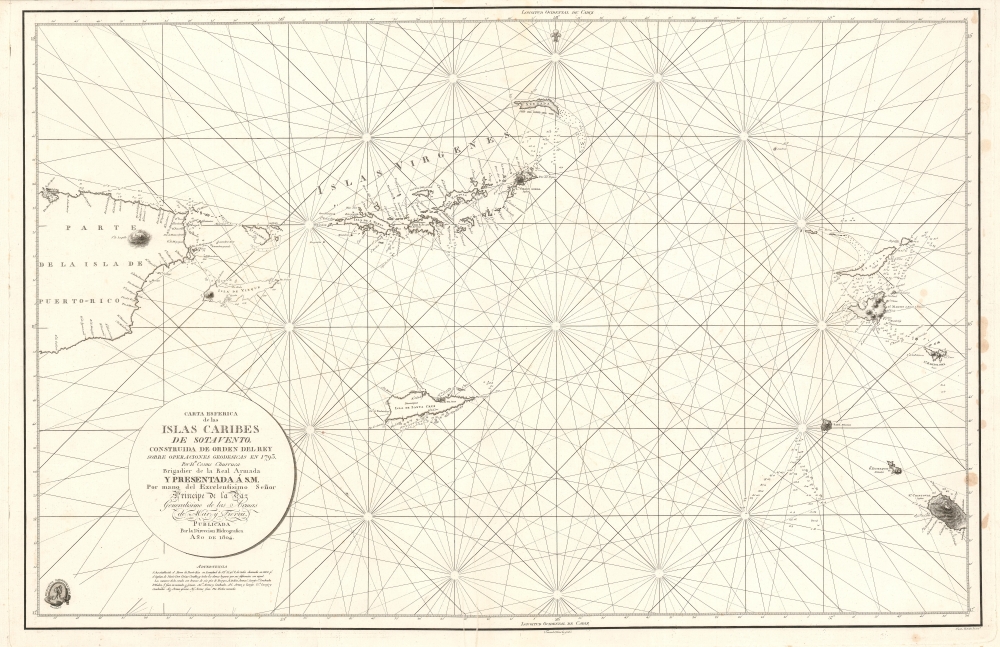
Carta Esferica de la Islas Caribes de Sotavento.
1804 (dated) 24.5 x 38.5 in (62.23 x 97.79 cm) 1 : 414000
1804 (dated) 24.5 x 38.5 in (62.23 x 97.79 cm) 1 : 414000
Description
A rare 1804 Direccion Hidrografica nautical chart or maritime map of the Virgin Islands. Centered on Virgin Gorda Island, the map covers from eastern Puerto Rico to St. Christopher and St. Barts. When it was printed, this was the finest map of the Virgin Islands yet produced, the result of a meticulous 1792 survey by Spanish officers Joaquin Francisco Fidalgo and Cosme Damián de Churruca y Elorza.
Historical Context
In the early 19th century, the Virgin Islands were primarily known for their strategic importance and their role in the colonial sugar economy. During this period, the islands were divided among several colonial powers, among the British, Danish, and Spanish. The economy was heavily reliant on sugar cane plantations, worked primarily by enslaved Africans. The early 19th century also saw occasional conflicts and rivalries among European powers over control of the Caribbean region, including the Virgin Islands, reflecting their strategic significance in maritime trade routes.Publication History and Census
This map was published by the Direccion Hidrografía in 1804. The map is based upon surveys completed by Spanish naval Brigadier Cosme Damián de Churruca y Elorza. The map was engraved by Fernando Selma, with the lettering added by Juan Morata.CartographerS
The Direccion Hidrografía (1787 - 1927), also known as the Deposito Hydrografico and the Direction de Hidrografía, was the Spanish equivalent of the British Admiralty or the U.S. Coast Survey. This organization, founded in 1787, was commissioned to collect and produce accurate nautical charts of all waters frequented by Spanish vessels. In essence, it replaced the Casa de la Contratación de las Indias (House of Trade of the Indies), which closed its doors in 1790. Like most such organizations, the Direccion Hidrografía marked a new age in cartography. Rather than simply collect charts created by navigators, explorers, and merchants, the Direccion Hidrografía worked closely with naval and military personnel to mount cartographic and hydrographic expeditions in pursuit of the most accurate hydrographical, astronomical, and geodetic measurements. The Direccion Hidrografía created a massive library of nautical charts that, though not nearly as common as similar nautical charts by the U.S. Coast Survey and British Admiralty, are highly desirable for the beauty of their manufacture as well as their accuracy and detail. The office was originally located on Calle Ballesta, but relocated to 36 Alcala, both in Madrid. After 1908 the Dirección was subsumed into other governmental agencies. In 1927 the Direccion was absorbed into the Institute and Observatory of San Fernando, located in Cadiz. The library of original maps, charts, and journals was transferred to the Naval Museum of Madrid - where it resides to this day. More by this mapmaker...
Cosme Damián de Churruca y Elorza (September 27, 1761 - October 21, 1805) was a Spanish-Basque naval officer active in the late 18th and early 19th centuries. Churruca was born in Mutriku, Gipuzkoa, northern Spain. He received his early education at the Seminary of Burgos before taking advanced studies at the School of Bergara. He graduated the Naval Academy of Ferrol in 1778. In 1781 as an Officer in the Spanish Navy, Churruca performed heroically in the siege of Gibralter. Along with Joaquin Francisco Fidalgo led an important 1792 expedition to map Spanish dominions in North American and the Caribbean - resulting in some of the earliest modern hydrographic studies of these regions. He died in the Battle of Trafalgar commanding the ship of the line San Juan Nepomuceno. Learn More...
Ferdinand Selma (1752 - January 8, 1810) was a Spanish line engraver active in Madrid with the Direccion Hidrografía in the late 18th and early 19th centuries. Selma was born in Valencia and died in Madrid. His is best known for his engravings for his 1788 Illustrations de Relacion del ultimo viage al estracho de Magallanes. Learn More...
Condition
Very good. Light spotting, right margin, else clean.
References
Harvard University, HOLLIS 990128489050203941.