This item has been sold, but you can get on the Waitlist to be notified if another example becomes available, or purchase a digital scan.
1794 Stockdale Map of the Virgin Islands
VirginIslands-stockdale-1794$350.00

Title
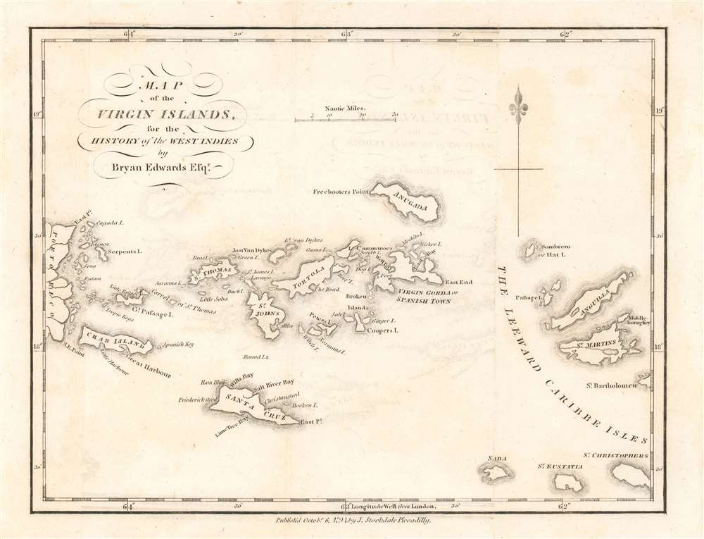
Map of the Virgin Islands, for the History of the West Indies.
1794 (dated) 7.5 x 9.5 in (19.05 x 24.13 cm) 1 : 1500000
1794 (dated) 7.5 x 9.5 in (19.05 x 24.13 cm) 1 : 1500000
Description
A rare 1794 map of the West Indies by John Stockdale and Bryan Edwards. This is one of the few 18th century specific maps of the Virgin Islands. The map covers from the eastern shores of Porto Rico to Saint Martin and Anguilla, covering all of the Virgin Islands, including St. Thomas, St. Johns, Tortola, Virgin Gorda, an Anagada (Anugada). The eccentric billionaire Sir Richard Branson's, private haven, Necker Islands, appears and is labeled just north of Virgin Gorda. At the northwest tip of Anegada Island, Freebooter's Point is noted - this is the only place on the island free of barrier reefs and a famous rendezvous point for 18th century pirates and buccaneers.
Edward's History
Bryan Edwards was a gentlemen Planter of Jamaica active in the 18th century. Edwards was politically moderate but a staunch opponent to the anti-slavery movement - which of course, as a planter, would be a treat this financial interests. His work is full of contradiction, arguing in one sentence that he is 'no friend to slavery, in any shape, or under any modification', and the next expressing his bitter opposition to abolitionist arguments. Instead, Edwards argued, the way forward was reform, proposing a system wherein slavery might gradually be phased out by attaching slaves 'to the land, [to be] sold with along it.' His writing defends this perspective form a historical point of view, providing at the same time, a contemporaneous account of West Indian history from a plantation owner's elevated position.Publication History and Census
This map was prepared by John Stockdale in 1794 for publication in Bryan Edwards 1794 The history, civil and commercial, of the British colonies in the West Indies, one of the classics of early West Indies literature. Examples of the work appear on the market from time to time, but the separate maps are rare.Cartographer
John Stockdale (March 25, 1750 - June 21, 1814) was an English book and map publisher active in London in the late 18th and early 19th centuries. Stockdale, born in Caldbeck, England, was trained by his father in the family trade of blacksmithing. Blacksmithing must not have been his cup of tea, for as soon as he was able, he left this trade in favor of a number of minor service positions, working at various times as a porter and a valet. One such position put him in the service of the bookseller John Almon. Having learnt the book trade by observing Almon, Stockdale opened his own bookshop and began publishing various historic and scientific works. Fellow publishers, perhaps reacting to his social status at birth, wrote of him, "being a man of natural parts, he soon became conspicuous in business in spite of much eccentricity of conduct and great coarseness of manners." Never quite accepted in the trade, Stockdale's fellow London publishers derogatorily referred to him as "The Bookselling Blacksmith". Nonetheless, Stockdale had a number of important works to his name, including several geographies, most notably the 1794American Geography 1794 and, with John Cary, the 1805 New British Atlas. More by this mapmaker...
Source
Edwards, Bryan The history, civil and commercial, of the British colonies in the West Indies. (London) 1794.
Condition
Very good. Slight transference. Else very clean.
References
OCLC 641544390.