This item has been sold, but you can get on the Waitlist to be notified if another example becomes available, or purchase a digital scan.
1942 Army Orientation Service Newsmap Map of the World
Vol1No27-newsmap-1942$250.00

Title
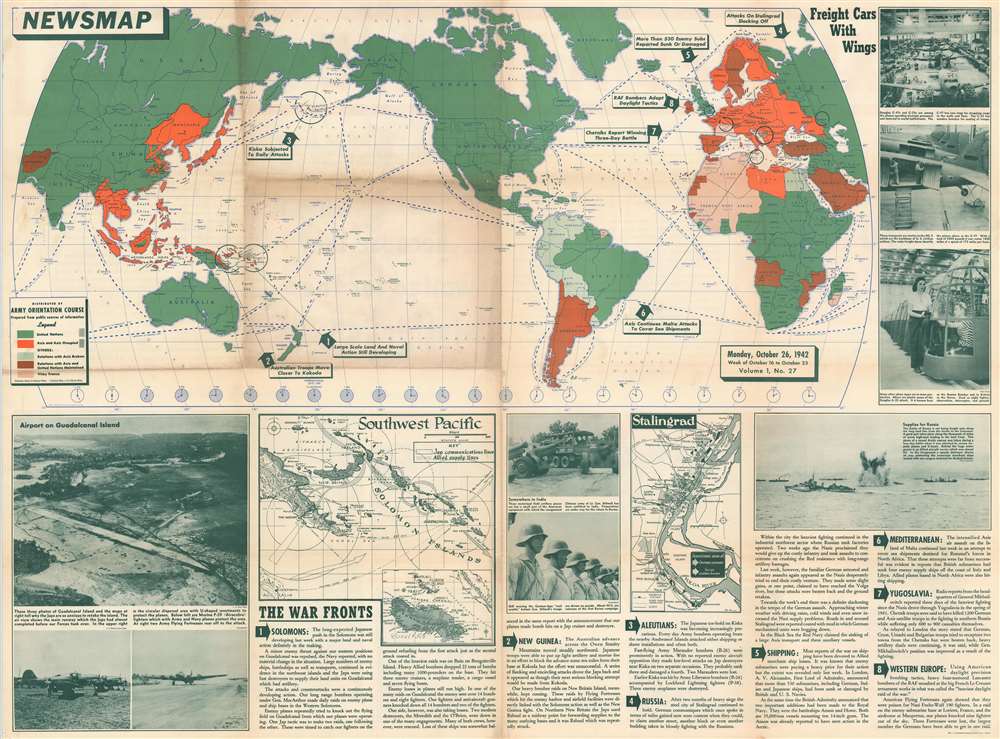
Newsmap. Monday, October 26, 1942 Week of October 16 to October 23. Volume 1, No. 27.
1942 (dated) 34.25 x 46 in (86.995 x 116.84 cm)
1942 (dated) 34.25 x 46 in (86.995 x 116.84 cm)
Description
This is a 1942 Army Orientation Course newsmap of the wold. Using colors, the territory of the 'United Nations' and Axis and Axis occupied territory are differentiated on the map occupying the upper half of the sheet, as are the sympathies of the rest of the world's nations. Eight numbered arrows point out important events in the war that took place all over the world, with circles emphasizing exactly where each action occurred. This week the Army Orientation Course chose to emphasize the continuing fight on Guadalcanal and New Guinea, as well as combat in the Aleutians, the siege at Stalingrad, and the blockade of Malta.
Events on the War Fronts
Below the map, short commentaries on these eight events are provided alongside printed photographs of the airfield on Guadalcanal, General Stilwell's troops in Burma, and an Atlantic convoy ferrying supplies to the embattled Russians. Two small maps provide much needed detail with respect to the situation in the vicinity of Guadalcanal and New Guinea and the attacks and counterattacks launched by both sides in the desperate fight for Stalingrad.History As It Happened
It is important to remember that in late October 1942, when this map was published, World War II was far from over and the outcomes of many critical battles were still unknown. The Battle of Stalingrad and the Battle of Guadalcanal, which had been raging for the last couple months, are highlighted here, and raged for five and six months in total, respectively.Publication History and Census
This map was created by the Army Orientation Service and published in 1942. The OCLC catalogues nine examples as being part of the institutional collections at Pennsylvania State University, Denison University, Ohio Wesleyan University, Davidson College, the Library of Michigan, Southern Illinois University at Edwardsville, Monmouth College, the University of Missouri, and the Denver Public Library.Cartographer
The Army Orientation Branch (1940 - c. 1949) created special maps for teaching the Army Orientation Course and was based at The Pentagon in Washington, D.C. The Army Orientation Branch was part of the Information and Education Division. More by this mapmaker...
Condition
Good. Verso repairs at fold intersections. One small area of infill. 'Foxholes are Life Savers' on verso.
References
OCLC 62470819.