
1900 Saussine Map and Game Board of Europe (unmounted proof)

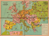

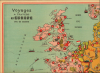
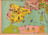
Voyages A Travers L'Europe Jeu de société.
French Belle Epoque Edutainment.
$750.00
Choose a Collection:
- Digital Map Information
- Suitable for large format printing
- Full resolution TIFF file
- ICC color profile embedded
- Delivered instantly via download link
This Item
Enquire
French Belle Epoque Edutainment.
This is an unmounted proof of an unrecorded c. 1900 pictorial four-sheet chromolithograph game board map of Europe, prepared by the Parisian game maker Saussine. It reflects the combination of didactics and entertainment common of French board games of the Belle Epoque.A Closer Look
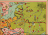
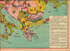
This game map consists of four sheets, likely originally intended to be mounted on a folding board. It covers Europe, including the British Isles, southern Scandinavia, and the western part of Russia (a portion of North Africa appears at bottom-left but is not on the circuitous route that players travel in the course of the game). Countries and territories are bordered and color-shaded. In a reflection of territorial ambiguity, Alsace-Lorraine is included within France's borders, though it is shaded the same orange as the rest of Germany. Illustrations throughout refer to local culture and history, including Napoleon in Corsica, a bagpipe-playing clansman in Scotland, a stein of beer in Bavaria, a clock in Switzerland, and so on, including a cannon pointing towards France in Alsace-Lorraine. Shipping lines and ships are also depicted.A route consisting of 120 points begins in Paris and winds through Europe, returning ultimately to Paris. Though not present here, the instructions at bottom-right make clear that the game involved rolling dice, collecting tokens, and moving individual players' pieces along the route. Hazards along the way, such as landing on a capital city, would cause players to be waylaid, and if they forgot to mention which country the city was capital of, they would have to pay out three tokens as a penalty. Alternatively, players could move ahead if landing on a space ending in a zero (a multiple of ten).
Historical Context
Around 1900, during France's Belle Epoque and the height of the Third Republic, jeux de société (board games) experienced a golden age driven by a distinct blend of pedagogical ambition and bourgeois family values. Following the major educational reforms of Jules Ferry, which made primary schooling free and compulsory, board games were widely adopted as 'edutainment' tools to foster literate, patriotic citizens. Publishers frequently adapted the mechanics of the traditional jeu de l'oie (Game of the Goose) into didactic race games focused on geography, history, and natural sciences. As seen in games like 'Voyages à travers l’Europe,' players were required to actively display knowledge, such as reciting capital cities or identifying regional landmarks, to avoid penalties.Simultaneously, these games served as a vivid reflection of the era's technological enthusiasm and a primary source of domestic entertainment. Beautifully illustrated via advanced chromolithography, the game boards captured the public's fascination with modern marvels like early aviation, cycling, and automobiles. The gameplay was deeply social, often incorporating, as here, a poule (a communal betting pot) to raise the competitive stakes and introducing whimsical rules to simulate the realities of modern travel, such as paying tariffs to cross seas.
Chromolithography
Chromolithography, sometimes called oleography, is a color lithographic technique developed in the mid-19th century. The process uses multiple lithographic stones, one for each color, to yield a rich composite effect. Generally, a chromolithograph begins with a black basecoat upon which subsequent colors are layered. Some chromolithographs used 30 or more separate lithographic stones to achieve the desired effect. Chromolithograph color can be blended for even more dramatic results. The process became extremely popular in the late 19th and early 20th centuries when it emerged as the dominant method of color printing. The vivid color chromolithography made it exceptionally effective for advertising and propaganda.Publication History and Census
This map was produced by the Parisian game maker Léon Saussine. It is undated and, from the borders present in Balkans, could date anywhere between 1878 and the Balkan Wars. But the reference to both bicycle and automobile variants of the game in the instructions leads us to believe that it was issued around the year 1900. This game map is rare, it is unrecorded in institutional collections and has only come to market once in recent years.Cartographer
Léon Saussine (unknown-1896) founded Saussine editions in 1860 and directed the company until his death in 1896, when he was succeeded by his widow and his sons. Saussine games published several types of games, including magnetic games. In 1878 Léon Saussine exhibited at the Exposition Universelle (World's Fair) in Paris. Further Details...
Condition
Excellent. 4 proof sheets unjoined. Each sheet roughly 12 x 16.5 in., 23.5 x 32.5 if joined.