1691 Jean Malet / Ottens Map of the Waldensian 'Glorieuse Rentrée', Piedmont, Italy
WaldensenReturn-ottens-1691$5,500.00

Title
Nieuwe Caerte der Valleyenin Piemont Door de Waldensen etc. Tegen alle Gewelt Beschernt. / Nouvelle Carte Des Vallees De Pieomont Etc, Vaillamment Defendues, Contre Toute Laviolenge Des Francois, Par Les Vaudois Reformes, Etc.
1691 (undated) 21 x 24 in (53.34 x 60.96 cm) 1 : 80000
1691 (undated) 21 x 24 in (53.34 x 60.96 cm) 1 : 80000
Description
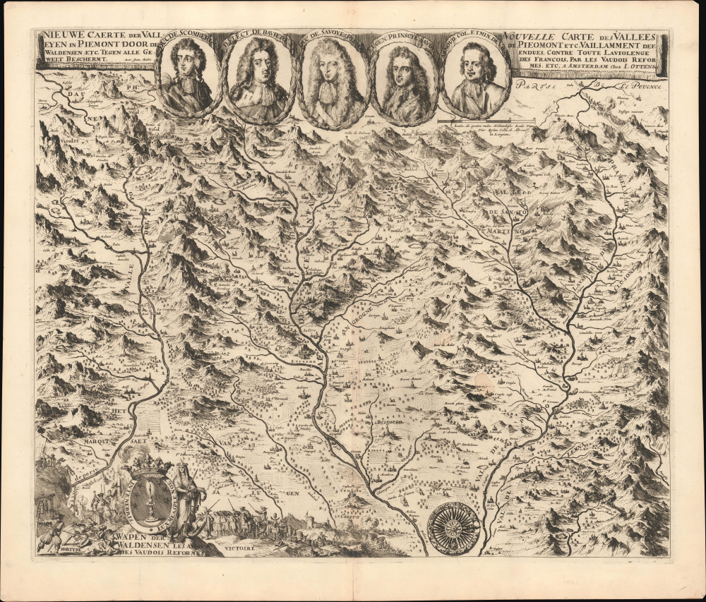
An extraordinary discovery of great rarity, the is the 1691 Malet / Ottens separate-issue map of the Piedmontese Alps illustrating the 1689 Glorieuse Rentrée of the Waldensians to their traditional Alpine valleys following their exile in the wake of the 1655 ethnic cleansing known as the Piedmontese Easter.
The scholar Giovanni Tarantino, picks up on the narrative with this map,
A Closer Look
Oriented to the west, coverage roughly embraces the western Piedmont between the headwaters of the Pò and the Deura Bàotia Rivers, including the valleys of the Eva d'Òr and Dòria Rivàira. Cartographically, the map derives from the 1640 map Carta delle tre valli di Piemonte by the Waldensian cartographer Valerius Crassus, with significant updates to reflect events current to 1691. The map is rife with gruesome scenes of Waldesian martyrdom, all referencing to the 1655 ethnic cleansing known as the Piedmontese Easter. A cartouche bearing the Waldesian candle emblem appears in the lower left and, in addition to martyrdom, also illustrates the 1689 Glorieuse Rentrée of the Waldensians from exile in Switzerland.Piedmontese Easter
This map followed in the wake of one of the most infamous events in the history of Protestantism in the Italian Alps. The 1655 'Piedmontese Easter' or the 'Massacre of the Waldensians' was a religious cleansing of the Waldensian sect in northern Italy. (The Waldensians, it must be noted, are the world's oldest reformed church, with origins in the 12th century, some say back to the 1st century, and thus anticipating the Reformation by at least 400 years.) The Duke of Savoy, Charles Emmanuel II, sent Catholic troops into the Waldensian valleys to force the inhabitants to convert to Catholicism or face annihilation. The result was a brutal massacre, with thousands of Waldensians killed, imprisoned, or forced into exile. Those who survived fled to Protestant regions, primarily Switzerland and the Netherlands, where they found succor and protection. The massacre attracted the attention of Protestant leaders across Europe, including Oliver Cromwell in England, who condemned the atrocities and offered aid to the survivors. In 1689, the Waldensian pastor Henri Arnaud (pictured here top right), led the Glorieuse Rentrée, in which those exiled to Switzerland returned in force to the Piedmontese Alpine valleys.The scholar Giovanni Tarantino, picks up on the narrative with this map,
Returning to the Protestant sphere, mention must also be made of Jean Malet's map (fig. 5), undated but probably from 1691, when the Waldensians and Piedmontese had joined forces against the common enemy: France. The map has a legend in Dutch and French making it clear that it is of the Piedmontese valleys defended by the Reformed Waldensians against French violence. Five medallions at the top depict the allied commanders present in Piedmont in the summer of 1691, besides the pastor Henri Arnaud, the leader of the Glorieuse Rentrée of the Waldensians from exile in Switzerland in 1689. Highlighting the change in the political situation and with it the destiny of the Piedmontese Waldensians, the illustrated lower part of Malet's map contrasts the ferocity of the martyrdom (Martyre) suffered (represented by men thrown from cliffs, burnings at the stake, hangings, and torture of all kinds) with the victory (Victoire) won on the field of battle and the magnanimity towards the losers. The two small illustrations frame the Waldensian emblem, by now regarded as a powerful and reassuring religious and territorial symbol, and at the same time a kind of warning to preserve memory, to support one another, and to trust in God.
Publication History And Census
This map is attributed to Jean Malet, about whom little is known and who produced no other known map. However, the Malet (or Mallet) family was prominent among the Huguenots of Geneva and there are records of several individuals bearing the name Jean Malet, none copperplate engravers or publishers. Although unsigned, scholars Ferruccio Jalla and Professor D. de Vries have positively attributed the map to the Dutch engraver Jan Luyken (1649 - 1712) by analyzing the engraving style and content. Luyken is known to have engraved many of the Ottens' most striking maps, so this revelation is enlightening if unsurprising. The printing and publication were carried out in Amsterdam by Joachim Ottens. Although undated, from the content, it must date to 1691. Rare. We note just three other examples: the British Library, Universitätsbibliothek Bern, and Universiteitsbibliotheek Leiden.Cartographer
Ottens (fl. c. 1680 - 1785) was a prominent Amsterdam map publishing family active for nearly 100 years. Joachim Ottens (1663 - 1719) was born in Amsterdam to a family of seafarers and educated in Amsterdam's Evangelical Lutheran community. He likely learned copperplate engraving under Frederick de Wit (1629 - 1706), for whom he worked until about 1710. In 1710, he was admitted to the Sint-Lucasgilde (Guild of St. Luke) and, in 1711, Joachim founded his own firm. Although Joachim died only a few years later, in 1719, his widow continued the business, either publishing as either 'I. Ottens', 'Ottens', or 'In de Wereldcaert' [In the World Map]. In 1726, Joachim Otten's sons, Renier (1698 - 1750) and Joshua (1698 - 1750), established a partnership and generally published as 'R. and I. Ottens'. Although they ran separate shops, on Nieuwendijk and Kalverstraat, they worked jointly as a singular business until Renier's death in 1750, at which point Joshua assumed full control. After Joshua's death in 1765, his widow continued the firm with their son, Renier II, changing the imprint to 'Joshua and Reinier Ottens.' Joshua's widow, Johanna de Lindt, held an auction sale of their engraved plates in 1784. Ottens' work stands out in that all of their maps were separate issues, though often found compiled into special, made-to-order multi-volume composite Atlas factice works, such as the Atlas. Some examples of the Atlas include over 800 separately issued maps. Because they were not uniformly issued in standard atlases, Ottens maps are often of the utmost rarity and are notable for their exceptionally rich engraving. More by this mapmaker...
Condition
Very good. Small water stain about 6 inches above the compass rose.
References
British Library Maps K.Top.76.37. Universitätsbibliothek Bern, Mue Ryh 3503 : 15. Tarantino, Giovanni, 'Mapping Religion (and Emotions) in the Protestant Valleys of Piedmont', ASDIWAL. Revue Genevoise d'Anthropologie et d'Distoire des Religions, 2014, pp. 91-105. University of Leiden, Port. 90 N 87, Port 138 N 65, and Port 200 N 72.