1911 Clason Pocket Map of Washington State
Washington-clason-1911$450.00


Title
Clason's Guide Map of Washington / Clason's Guide to Washington with Map.
1911 (dated) 16 x 23.75 in (40.64 x 60.325 cm) 1 : 1140000
1911 (dated) 16 x 23.75 in (40.64 x 60.325 cm) 1 : 1140000
Description
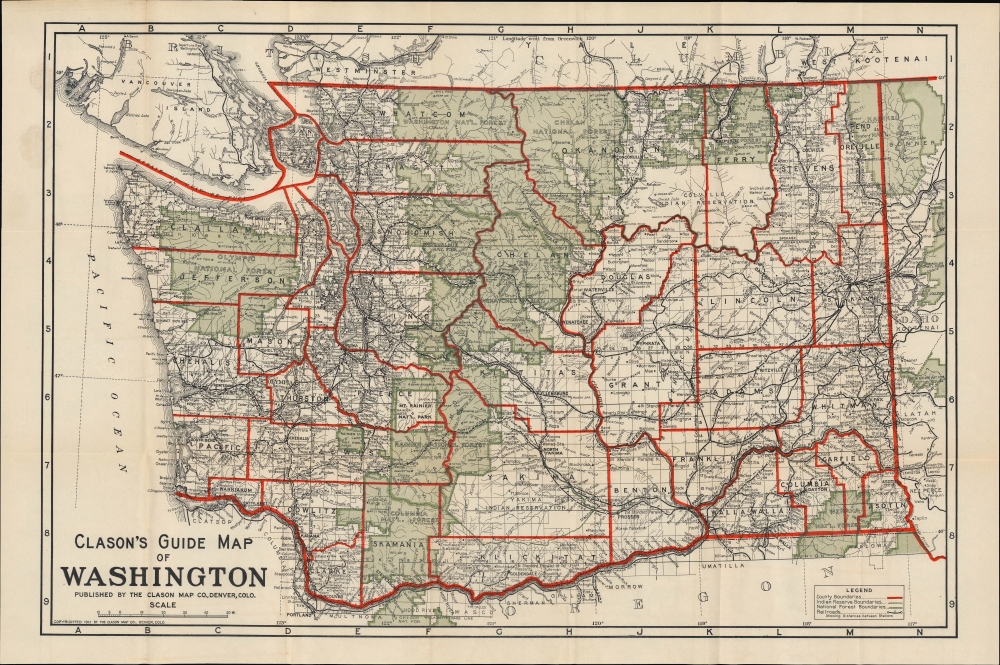
This is a 1911 pocket map of Washington state prepared by the Clason Map Company, the earliest such map of Washington prepared by the company.
A Closer Look
The state of Washington is displayed along with portions of Oregon, Idaho, and British Columbia. Red lines trace county boundaries, while black lines form a grid of latitude and longitude lines. Green shading denotes national forests. Cities and towns, mountains, waterways, and other features are labeled throughout.Railroads to the Pacific
Rail lines, traced in black, stand out prominently, with the distances between stations recorded. Significantly, automobile roads are not noted, though they did exist. The state had established a Highway Board in 1905 and was working to improve existing dirt and gravel roads, but, as the map reflects, the vast majority of travelers continued to use railways, which had been built in profusion in the Pacific Northwest in the late 19th and early 20th century (note the density around Spokane in particular); in fact, the map displays several lines still under construction. Most of these lines belonged to two competing systems, the Great Northern Railway and the Northern Pacific Railroad. The Chicago, Milwaukee, and Puget Sound Railway, part of the larger 'Milwaukee Road' system, which had only reached Puget Sound a couple of years prior, is also indicated. The Oregon Railroad and Navigation Company that operated along the Columbia River had just become a subsidiary of the Union Pacific in 1910. The Canadian Pacific Railway appears near the top. Other lines, mostly local operations used for logging, are also traced. Many of these companies overbuilt their networks, spending millions to gain a slight advantage, and went deep into debt, leading to a raft of consolidation and closure of unprofitable lines in the early 20th century.American Indian Reservations
The map also notes the location of several American Indian reservations, the largest of which are the Colville and Yakima (Yakama) Reservations. The former was and remains home to a mix of a dozen 'confederated tribes,' including the Chief Joseph band of Nez Piece. (The great chief died on the reservation in 1904.) Smaller reservations, such as the Hoh Indian Reservation along the Pacific coast of the Olympic Peninsula and the Lummi Reservation near Bellingham, are also indicated. At the end of the 19th century, following the 1887 Dawes Act (also known as the General Allotment Act), federal Indian policy shifted significantly towards cultural assimilation, including the allotment of land in private plots to encourage the adoption of a lifestyle similar to that of white settlers in the region. The implementation of these policies was often haphazard and inconsistent but generally disadvantaged Indians. It justified reducing the size of reservations (as happened to the Colville Reservation) to create opportunities for white settlers to acquire reservation land.Publication History and Census
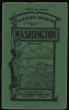
This map and guide were prepared by the Clason Map Company of Denver in 1911. It represents an early example of the iconic Clason 'Green Guides' that were produced into the 1930s. These pocket guides and maps are so called because of their distinctive green cover adorned with the image of a woman (Lady Liberty or a Native American woman, depending on the year). The present map was both the earliest Clason pocket map of Washington and the earliest 'Green Guide' for Washington. Later editions of the Clason 'Green Guide' for Washington were published every several years, and the lack of automobile roads here is especially notable since later 'Green Guides' prided themselves on providing up-to-date information on the developing road network in the American West. The present, first edition of this map is especially scarce, only noted among the holdings of the University of Washington.Cartographer
George Samuel Clason (November 7, 1874 - 1957) was born in the city of Louisiana, Missouri in 1874. As a young man, Clason studied at the University of Nebraska before joining the United States Army in 1898 to fight in the Spanish American War. After the war, he moved to Denver, Colorado where in 1905 he founded the Clason Map Company, thus starting his lucrative publishing career. Clason initially focused on mining and mineral maps - capitalizing on the Colorado and Nevada mining industry, but quickly transitioned to railroad maps, city maps, and by the 1920s, road maps. As the company expanded, Clason opened a secondary office in Chicago, Illinois - then a rising map publishing center and railroad hub. At least one other satellite office was opened in Los Angeles. Among his many achievements, Clason is credited with producing the first modern road atlas of the United States. In the late 1920s, Clason also published a series of get-rich-quick pamphlets in the form of parables. The most famous of these is The Richest Man in Babylon. This tells the story of Arkad, a citizen of Babylon famed for his great wealth and generosity who shares his wit and wisdom with his fellow Babylonians. In 1949, Clason moved to Napa, California to retire and found a social club for retired gentlemen. More by this mapmaker...
Condition
Very good. Light wear along original fold lines. Verso repairs to fold separations and at fold intersections. Closed edge tears professionally repaired on verso. Accompanied by original booklet.
References
OCLC 1033412064. Liedholm, C., 'Clason's Green Guides' The Legend (Road Map Collectors Association), No. 50, (Spring 2011) p. 8-11.