
1955 Kroll Map of Washington State

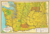

State of Washington / A Map of the State of Washington.
Plutopia.
Plutopia.
This is a colorful c. 1955 Kroll map of Washington State. Among other features, it is notable for highlighting the location of the Hanford Site, established during the Manhattan Project, the location of the first full-scale plutonium production reactor.A Closer Look
Coverage includes the state of Washington, with county lines traced prominently in red. Roads and highways of various qualities are noted according to the legend at bottom-right, as are railroads, ferry lines, cities and towns, airports, mountains (with elevations), waterways, state and national parks (shaded green), Indian reservations (shaded brown), and other features. The 'Hanford Project U.S. Atomic Energy Reservation' is noted in the state's south-central part, to the east of Yakima.The Hanford Site and the Manhattan Project
The Hanford Site in Washington was established in 1943 as part of the Manhattan Project, chosen for its remote location along the Columbia River, abundant water supply, and access to hydroelectric power. Its most famous facility was the B Reactor, the world's first full-scale plutonium production reactor, which produced the plutonium used in the 'Fat Man' atomic bomb dropped on Nagasaki in 1945. After the war, Hanford expanded into a massive complex of nine reactors and five reprocessing plants, producing most of the plutonium for the U.S. nuclear arsenal during the Cold War (1947 - 1991).Needless to say, these ventures brought dramatic change to the region. Sparsely populated farmland turned into a model mid-century American suburb in a matter of months. However, these operations generated vast quantities of radioactive and chemical waste, some of which has contaminated the surrounding air, water, and soil. Early storage facilities also proved to be inadequate for long-term storage of nuclear waste, leading to dangerous leaks. Cancer rates in surrounding communities are abnormally high.
New plutonium production was wound down in the 1960s and 1970s, and since the 1980s, the site has been the focus of one of the largest and most complex environmental cleanup projects ever undertaken, employing more than 10,000 workers.
Publication History and Census
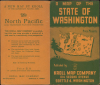
This map was issued as a folding map by the Kroll Map Company, based in Seattle. It is undated, but likely dates from the early to mid-1950s. Although the Hanford site is noted, the town of Richland, where most of its workers lived, is not present; it became a self-governing town in 1958 and appears on maps thereafter. The use of 'Chelan National Forest' in the northern part of the state would seem to indicate a date of 1955 (when its name was changed to Okanogan) or earlier. Therefore, 'Interstate highways' here does not refer to the interstate system established in the late 1950s but the pre-existing U.S. Routes that traversed state lines.Due to uncertainty over the date and the publication of multiple undated editions, a true census is difficult to establish. The OCLC notes five examples a Kroll map of Washington state from roughly the 1950s - 1960s, located at the University of California Los Angeles, the University of Oregon, the University of Washington, the Washington State Library, and the University of Wisconsin Milwaukee.
Cartographer
Kroll Map Company (1911 - Present) is a Seattle-based map company. Founded in 1911 when Carl Kroll acquired both Anderson Map Company and Washington Map and Blueprint Company, both of which had been in business since the 1870s. From its inception, Kroll Map Company has ‘focused on mapping for real estate and local government, custom mapping, and the publication of numerous general mapping products.’ Carl Kroll sold a half-share of the company to John Loacker, his close friend and employee, in 1920. Loacker then purchased the company outright in 1925. He maintained the feel of a family business by working with his son Waldemar, who eventually took over. Waldemar J. Loacker (April 16, 1902 - February 12, 1995) worked at Kroll for the rest of his life, only leaving the company after suffering a stroke in 1992. Then his son John Loacker (b. 1955), who began working at Kroll in his youth, officially inherited the business and continues operating it to this day. In 1999, Kroll Map Company and Metsker Maps of Seattle formed a partnership of ‘two historic Seattle businesses.’ Today, the Kroll Map Company creates custom maps for individuals worldwide. Further Details...
Condition
Very good. Light wear along original fold lines. Slight loss at a few fold intersections.
References
OCLC 18585022. Brown, K, Plutopia: Nuclear Families, Atomic Cities, and the Great Soviet and American Plutonium Disasters, (New York: Oxford University Press) 2013.