
This item below is out of stock, but another example (left) is available. To view the available item, click "Details."
Details
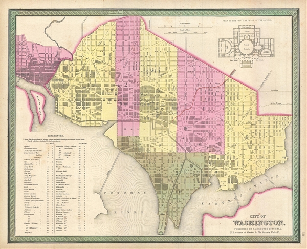
1846 Mitchell Map of Washington D.C. w/Georgetown
1846 (dated) $350.00
1849 Mitchell Map of Washington D.C. w/Georgetown
WashingtonDC-mitchell-1849$175.00

Title
City of Washington
1849 (undated) 13 x 16 in (33.02 x 40.64 cm) 1 : 22000
1849 (undated) 13 x 16 in (33.02 x 40.64 cm) 1 : 22000
Description
This is a fine example of Samuel Augustus Mitchell's 1849 map or plan of Washington D.C. Given that most of Washington D.C. was under construction when this map was drawn, Mitchell's plan is a remarkable combination of existing of existing cartography and future projections. Though Pierre Charles L'Enfant's brilliant plan for the national capital is evident in the grid and ray layout, and many of the great national monuments are identified, the practically of the national capital was that even in 1849, more than 50 years after the city's construction began, Washington D.C. remained little more than a ragtag cluster of Grecian monuments surrounded by dense forest. Anthony Trollop, an English novelist, remarked on the barrenness of D.C.,
This map was issued in the 1849 edition of the New Universal Atlas. It was the last edition of that atlas to be published by Mitchell prior to selling the plates and rights to the atlas to Thomas Cowperthwait in 1850.
There is a map of Washington accurately laid down; and taking that map with him in his journeying a man may lose himself in the streets, not as one loses himself in London between Shoreditch and Russell Square, but as one does so in the deserts of the Holy Land, between Emmaus and Arimathea. In the first place there no one knows where the places are, or is sure of their existence, and then, between their presumed localities the country is wild, trackless, unbridged, uninhabited, and desolate… If you are a sportsman, you will desire to shoot snipe within site of the President's House.Nonetheless, a city was emerging, with rail lines, bridges, parks, and city wards, surveyed and laid down for the construction teams. The Capitol Building, the floor plan of which appears in the upper right quadrant, was one of the first buildings in Washington to be completed and was functional by about 1846, though, admittedly, was a very different building than we known today. A further list of extant and proposed monuments and government buildings, along with their wards and numerical identifiers, appears in the lower left quadrant.
This map was issued in the 1849 edition of the New Universal Atlas. It was the last edition of that atlas to be published by Mitchell prior to selling the plates and rights to the atlas to Thomas Cowperthwait in 1850.
Cartographer
Samuel Augustus Mitchell (March 20, 1792 - December 20, 1868) began his map publishing career in the early 1830s. Mitchell was born in Bristol, Connecticut. He relocated to Philadelphia in 1821. Having worked as a school teacher and a geographical writer, Mitchell was frustrated with the low quality and inaccuracy of school texts of the period. His first maps were an attempt to rectify this problem. In the next 20 years Mitchell would become the most prominent American map publisher of the mid-19th century. Mitchell worked with prominent engravers J. H. Young, H. S. Tanner, and H. N. Burroughs before attaining the full copyright on his maps in 1847. In 1849 Mitchell either partnered with or sold his plates to Thomas, Cowperthwait and Company who continued to publish the Mitchell's Universal Atlas. By about 1856 most of the Mitchell plates and copyrights were acquired by Charles Desilver who continued to publish the maps, many with modified borders and color schemes, until Mitchell's son, Samuel Augustus Mitchell Junior, entered the picture. In 1859, S.A. Mitchell Jr. purchased most of the plates back from Desilver and introduced his own floral motif border. From 1860 on, he published his own editions of the New General Atlas. The younger Mitchell became as prominent as his father, publishing maps and atlases until 1887, when most of the copyrights were again sold and the Mitchell firm closed its doors for the final time. More by this mapmaker...
Source
Mitchell, S. A., A New Universal Atlas, (S. A. Mitchell; Philadelphia) 1849.
The New Universal Atlas is one of the great American atlases of the mid-19th century. Samuel Augustus Mitchell first issued the atlas in 1846 when he acquired the map plates and copyright for Tanner's New Universal Atlas from its publisher, Carey and Hart. The first transitional 1846 edition was published jointly with Carey and Hart, but a second edition was published in the same year with the Tanner imprint erased. This edition of the atlas also introduced the signature S. A. Mitchell green and pink color scheme. Most of the maps from the early editions of the atlas were engraved by H. N. Burroughs or C. S. Williams, often bearing their copyright. Burroughs maps also tended to have what map collector David Rumsey refers to as the 'Cary and Hart' borders, which featured a narrow vine motif. These borders were replaced, along with the Burroughs imprint, with the more traditional Mitchell strap work border used in the atlases until 1856. Mitchell published editions until late in 1850, when he sold the rights to Thomas, Cowperthwait and Company of Philadelphia. Under Cowperthwait, the atlases continued to be published and bear the Mitchell name until 1856, when the plates were again sold, this time to Charles Desilver. Desilver reworked the plates with new border art and a revised color scheme in the style of J. H. Colton. Desilver issued editions from 1857 to 1860, when the atlas was phased out in favor of Samuel Augustus Mitchell Jr.'s New General Atlas.
Condition
Very good condition. Blank on verso. Bright and clean.
References
Rumsey 0537.017 (1846 edition). Phillips (Atlases) 814.