1868 Morrison Map of Washington, D.C.
WashingtonDC-morrison-1868$300.00

Title
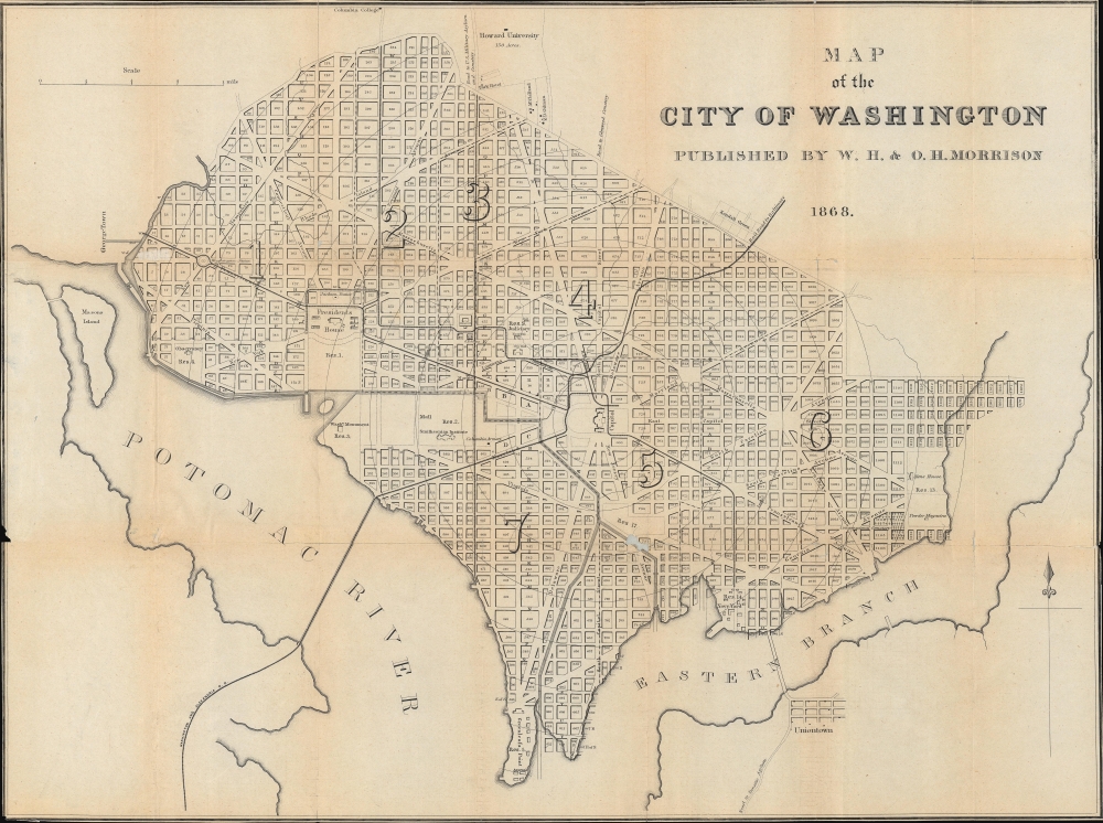
Map of the City of Washington.
1868 (dated) 15.5 x 20.75 in (39.37 x 52.705 cm) 1 : 18500
1868 (dated) 15.5 x 20.75 in (39.37 x 52.705 cm) 1 : 18500
Description
A fascinating map of early Reconstruction-era Washington, D.C., produced in 1868 by W.H. and O.H. Morrison for their city guide. It presents the city as the early phases of a major renovation that would completely reshape it were underway.
The Civil War transformed the city, with an influx of soldiers, as well as bureaucrats to administer the much-expanded federal government. After the war, Congress passed the Organic Act of 1871 to effectively unify Washington and Georgetown and establish a local government to administer the district. Alexander Robey Shepherd was appointed by President Grant as the governor of the district in 1873 and immediately undertook ambitious public works projects which gave the city paved roads, proper sanitation, and other modern infrastructure, but bankrupted it in the process. Though the federal government was beset by fiscal difficulties in the late 19th century, its expanding writ demanded new structures to house a growing bureaucracy, while continued efforts were made to beautify the city, resulting, for instance, in reclamation of the muddy banks of the Potomac (Potomac Flats) to expand the National Mall to the west of what is seen here.
A Closer Look
The contemporary city of Washington (i.e., minus Georgetown) is displayed, divided into wards, and with individual city blocks numbered. Concentric circles emanate from the U.S. Capitol Building at one-mile intervals. A variety of means of public transportation are indicated, including the 'Rail Road to Baltimore' (Baltimore and Potomac Railroad) and the Washington and Alexandria Railroad. Other dashed lines represent early horse-drawn streetcar lines, such as the Washington and Georgetown Railroad, which ran up Pennsylvania Avenue, while white and black alternating lines represent omnibus service. Major government buildings are labelled but the National Mall remains fairly minimal, with a partially completed Washington Monument and the Smithsonian Institution Building (the 'Castle') being the only structures present. Recently established Howard University stands out at top, as does nearby Columbia College, the basis for George Washington University.Transformation of the Nation's Capital
Until the American Civil War (1861 - 1865), Washington, D.C. was a small and not especially liked city; infrastructure was lacking, summers were hot and miserable (and the city emptied out while Congress was not in session), disease was rife, and there was little imposing architecture befitting the center of a great nation. The U.S. Capitol Building had undergone significant renovations and expansion in the previous decade, but its impressive new dome was not completed by the time of Lincoln's first inauguration, nor was the Washington Monument, which had been under construction since 1854 but delayed repeatedly.The Civil War transformed the city, with an influx of soldiers, as well as bureaucrats to administer the much-expanded federal government. After the war, Congress passed the Organic Act of 1871 to effectively unify Washington and Georgetown and establish a local government to administer the district. Alexander Robey Shepherd was appointed by President Grant as the governor of the district in 1873 and immediately undertook ambitious public works projects which gave the city paved roads, proper sanitation, and other modern infrastructure, but bankrupted it in the process. Though the federal government was beset by fiscal difficulties in the late 19th century, its expanding writ demanded new structures to house a growing bureaucracy, while continued efforts were made to beautify the city, resulting, for instance, in reclamation of the muddy banks of the Potomac (Potomac Flats) to expand the National Mall to the west of what is seen here.
Publication History and Census
This map was produced in 1868 by W.H. and O.H. Morrison for their Morrison's Stranger's Guide to the City of Washington, and its vicinity. Neither this edition of the map nor the entire guide are listed among the holdings of any institution in OCLF, with the closest match being the 1872 edition of the map (OCLC 857727252), held by Georgetown University and the Library of Congress.Cartographer
William H. Morrison (fl. c. 1880 - 1910) was a law book specialist, publisher, and stationer active in Washington D. C. during the latter part of the 19th century and early 20th century. He often published with 'O.H. Morrison,' presumably his brother, with whom he inherited the works of William M. Morrison, presumably his father. The Morrisons were best known for their Morrison's stranger's guide to the City of Washington and its vicinity, published between the 1840s and 1890s.
Morrison was described thus by his contemporaries:
W. H. Morrison is, in the usual term, a hustler, being his own solicitor. By scouting surrounding towns is a fast building up a good trade. His long experiences in the line and extensive acquaintance give him at once a good position in the trade. -The American Stationer Feb 4, 1892.Morrison printed maps and Guides to Washington D.C. as well acted as a bespoken stationer and a government printer. Among other things, Morrison was a strong advocate of paper currency - no doubt hoping to get an edge on the business of printing money. He maintained a storefront at 475 Pennsylvania Ave, N.W. More by this mapmaker...
Source
Morrison, W.H. and O.H., Morrison's Stranger's Guide to the City of Washington and its Vicinity, (Washington, D.C.: W.H. and O.H. Morrison) 1868.
Condition
Average. Toning at fold intersections. Multiples tears in upper left and middle right of map, professionally repaired on verso. Section about one inch of content missing in lower right quadrant.