
1923 Olsen Pictorial Bird's Eye View Map of Washington, D.C.


This item has been sold.
Washington The Beautiful Capital of the Nation.
Washington, D.C. emerging as a federal metropolis.
Choose a Collection:
- Digital Map Information
- Suitable for large format printing
- Full resolution TIFF file
- ICC color profile embedded
- Delivered instantly via download link
This Item
Enquire
Washington, D.C. emerging as a federal metropolis.
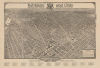
This is a 1923 William Olsen bird's-eye view of Washington, D.C., issued for the Baltimore and Ohio Railroad. When issued, the B-and-0 was well established as the primary artery of access to Washington, D.C., moving politicians, diplomats, soldiers, bureaucrats, mail, and goods in and out of the capital. It represented stability and modernity at a moment when the city was transforming from a bureaucratic town into a federal metropolis.A Closer Look
Oriented toward the southwest, the view depicts the city from the U.S. Capitol Building south to Virginia and Maryland. Beautifully drawn, individual buildings throughout Washington are discernible, and numerous locations are labeled. Some of the important government buildings illustrated in three dimensions include the Library of Congress, the Smithsonian Institution (comprised of the Smithsonian Castle, the Arts and Industries Building, and the National Museum of Natural History), several buildings occupied by the War Department and the Navy Department, the Washington Monument, the Lincoln Memorial, and the White House. George Washington University, Georgetown University, and Howard University are also identified. Several different YMCA locations are named around the city, along with an orphan asylum, hotels, and electric and telephone companies. An index of public buildings and other places of interest is situated below the bottom border.Publication History and Census
This view is unusual and appears late in the view-making tradition. It was created by William Olsen and published by the Baltimore and Ohio Railroad in 1923. OCLC records holdings at the Library of Congress, Yale University, the University of Connecticut, George Washington University, Pennsylvania State University, and the Carnegie Library of Pittsburgh. It had previously been published in a large-format edition in 1921 and in 1922 by the Columbia Planograph Company - that edition is distinguished by heavier stock and the lack of the Baltimore and Ohio promotional content.Cartographer
William Olsen (fl. c. 1920 - 1925) was an American artist. He is credited with producing three different bird's eye views of Washington, D.C. Further Details...
Condition
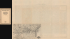
Excellent. Small map of Baltimore and Ohio Railroad network on verso.
References
OCLC 5484264.