This item has been sold, but you can get on the Waitlist to be notified if another example becomes available, or purchase a digital scan.
1864 Mitchell Plan or Map of Washington D. C.
WashingtonDC2-mitchell-1864$100.00

Title
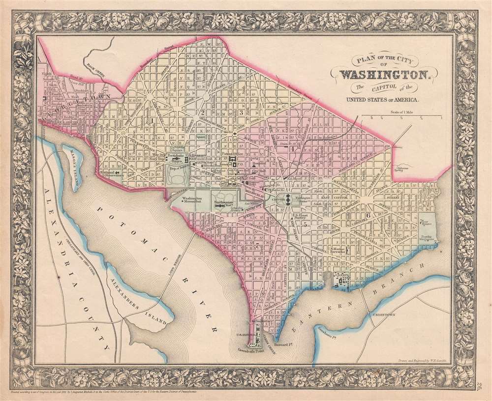
Plan of the City of Washington, The Capitol of the United States of America.
1861 (dated) 12 x 14 in (30.48 x 35.56 cm) 1 : 27500
1861 (dated) 12 x 14 in (30.48 x 35.56 cm) 1 : 27500
Description
This is an 1861 S.A. Mitchell, Jr. city map or plan of Washington, D.C. The map depicts the city from Georgetown to the Anacostia River (Eastern Branch) and from Boundary Street to Greenleafs Point and the confluence of the Anacostia and Potomac Rivers. Highly detailed, numerous buildings throughout the city are labeled, including the U.S. Capitol Building, the Smithsonian Institution, the Washington Monument, and the President's House. The Navy Department, War Department, and U.S. Treasury are also identified, as are the Patent Office, the General Post Office, the U.S. Navy Yard, and the U.S. Arsenal. Nearly every street in the city is labeled, and Washington, D.C.'s iconic street layout is easily recognizable. The Chesapeake and Ohio Canal, which eased river travel along the Potomac, and is across the river from Washington, D.C. in Alexandria, Virginia, is illustrated and labeled.
This map was prepared by S. A. Mitchell Jr. for inclusion in the 1861 edition of Mitchell's New General Atlas. Like many American map publishers of this period, though, he did update his maps, Mitchell did not update his copyrights, consequently this map is dated and copyrighted to 1861: 'Entered according to Act of Congress in the Year 1861 by S. Augustus Mitchell Jr. in the Clerk's Office of the District Court of the U.S. for the Eastern District of Pennsylvania.'
This map was prepared by S. A. Mitchell Jr. for inclusion in the 1861 edition of Mitchell's New General Atlas. Like many American map publishers of this period, though, he did update his maps, Mitchell did not update his copyrights, consequently this map is dated and copyrighted to 1861: 'Entered according to Act of Congress in the Year 1861 by S. Augustus Mitchell Jr. in the Clerk's Office of the District Court of the U.S. for the Eastern District of Pennsylvania.'
Cartographer
Samuel Augustus Mitchell (March 20, 1792 - December 20, 1868) began his map publishing career in the early 1830s. Mitchell was born in Bristol, Connecticut. He relocated to Philadelphia in 1821. Having worked as a school teacher and a geographical writer, Mitchell was frustrated with the low quality and inaccuracy of school texts of the period. His first maps were an attempt to rectify this problem. In the next 20 years Mitchell would become the most prominent American map publisher of the mid-19th century. Mitchell worked with prominent engravers J. H. Young, H. S. Tanner, and H. N. Burroughs before attaining the full copyright on his maps in 1847. In 1849 Mitchell either partnered with or sold his plates to Thomas, Cowperthwait and Company who continued to publish the Mitchell's Universal Atlas. By about 1856 most of the Mitchell plates and copyrights were acquired by Charles Desilver who continued to publish the maps, many with modified borders and color schemes, until Mitchell's son, Samuel Augustus Mitchell Junior, entered the picture. In 1859, S.A. Mitchell Jr. purchased most of the plates back from Desilver and introduced his own floral motif border. From 1860 on, he published his own editions of the New General Atlas. The younger Mitchell became as prominent as his father, publishing maps and atlases until 1887, when most of the copyrights were again sold and the Mitchell firm closed its doors for the final time. More by this mapmaker...
Source
Mitchell's New General Atlas, containing maps of the various countries of the World, plans of cities, etc., (1867 edition).
Condition
Very good. Even overall toning. Blank on verso.
References
Rumsey 0579.023 (1868 edition).