This item has been sold, but you can get on the Waitlist to be notified if another example becomes available, or purchase a digital scan.
1901 Norris Peters Map of Washington D.C. w/ Diphtheria Scarlet Fever Mortality
WashingtonDCDiphtheria-norrispeters-1901$250.00

Title
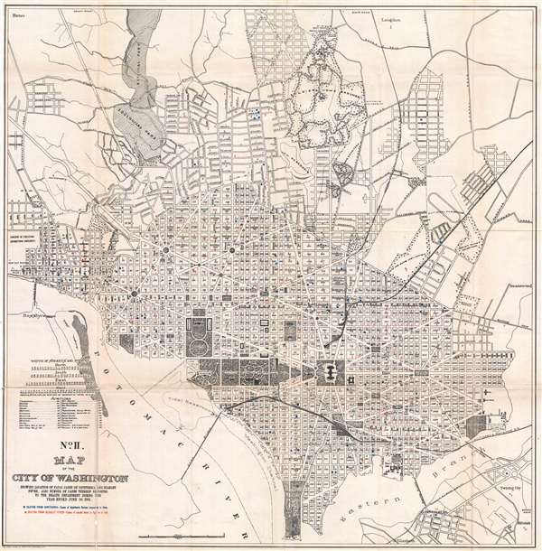
No. II. Map of the City of Washington Showing Location of Fatal Cases of Diphtheria and Scarlet Fever, also Number of Cases Thereof Reported to the Health Department During the Year Ended June 30, 1901.
1901 (dated) 28 x 27.5 in (71.12 x 69.85 cm) 1 : 13500
1901 (dated) 28 x 27.5 in (71.12 x 69.85 cm) 1 : 13500
Description
A fascinating 1901 Norris Peters map of Washington D.C. illustrating fatal cases of diphtheria and scarlet fever, as well as the number of cases reported. This large map covers from the Rock Creek Cemetery to Haines Point and from Georgetown to the Anacostia River. City Blocks are identified numerically. The map has been overprinted with a symbol to illustrate fatal cases of diphtheria and scarlet fever throughout the city. The map also includes the information of how many cases of these two diseases were reported over the course of the year. This is intriguing, because of the five maps in this series that we have seen, this is the only map that includes statistics on the number of reported cases.
The map is part of a series printed by the Norris Peters Company of Washington D. C. to illustrate a report to the Commissioners of the District of Columbia. This map appears to be quite rare. We have been able to identify one other example in an institutional collection.
The map is part of a series printed by the Norris Peters Company of Washington D. C. to illustrate a report to the Commissioners of the District of Columbia. This map appears to be quite rare. We have been able to identify one other example in an institutional collection.
Cartographer
Norris Peters (c. 1834 – July 15, 1889) was a Washington D.C. based photo-lithographer active in the late 18th and early 19th century whom Scientific American called 'one of Washington's most eccentric and mysterious figures.' Peters was born and educated in Pennsylvania. He relocated as a young man to Washington D.C. where he took work as an examiner for the United States Patent Office. During his work with the patent office he became fascinated with the emergent process of photolithography. In 1869 Peters secured substantial venture capital of about 100,000 USD from an unknown investor and founded The Norris Peters Company at 458 Pennsylvania Avenue. Their printing offices have been described as 'unequaled in this or any other country.' From these offices Peters pioneered the development of American photo-lithography. For nearly a generation he held a near monopoly on government photo-lithographic printing. Among their more notable contracts included numerous maps for congressional reports, maps of the U.S. Coast Survey, maps of the U.S. Geological Survey, Mexican currency for the State of Chihuahua, and the Official Gazette of the Patent Office. Peters also maintained an interesting social life and was a confidant to many of the most powerful figures in Congress. He was also a bon vivant known for being an excellent cook and hosting lavish dinners, the invitations to which were 'never declined'. Despite being socially active he never married and died a confirmed bachelor. Following Peters' death in 1889 his business was taken over by Henry Van Arsdale Parsell who administered it until his own death in 1901. The company then merged with Webb & Borcorselski, another D.C. lithography firm, and was renamed Webb & Borcorselski-Norris Peters. They continued to publish under this name well into the mid 20th century. More by this mapmaker...
Condition
Very good. Backed on archival tissue for stability. Wear and slight soiling along original fold lines.
References
OCLC 959729078.