
1861 Walling Wall Map of Washington County, Maine

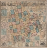
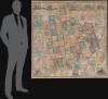
Topographical Map of the County of Washington Maine From Actual Surveys under the Direction of H. F. Walling.
Maine's Epic North Coast.
$3,000.00
Choose a Collection:
- Digital Map Information
- Suitable for large format printing
- File Size: 275.71 MB
- File Type: ZIP / TIFF
- ICC color profile embedded
- Delivered instantly via download link
This Item
Enquire
Maine's Epic North Coast.
This is the 1861 Henry F. Walling map of Washington County, Maine. Washington County encompasses Maines's north coast, extending roughly from Mount Desert Island to the Canadian border.A Closer Look
Coverage embraces Washington County from Topsfield to Petit Manon Island and from the Naraguagus River to Deer Island. Towns are labeled throughout, with individual homes and businesses identified both within and outside towns. Twenty-seven inset maps encircle the central map, including 26 town plans and a map expanding covering the northernmost parts of the county. A large inset in the upper right corner highlights Calais and Milltown, illustrating city wards and labeling residences, churches, businesses, and schools. A second large inset depicts Machias. Some of the other towns detailed include Pembroke, East Machias, Cherryfield, Eastport, Lubec, and Dennysville. Six pictorial vignettes illustrate Libby Hall in Machias, the Congregational Church in Machias, the Washington Academy in East Machias, the Washington County Courthouse in Machias, the Calais Academy and Normal School in Calais, and the Washington County Jail in Machias.Publication History and Census
This map was drawn, engraved, printed, colored, and mounted at H.F. Walling's Map Establishment in New York City in 1861. We note 5 examples cataloged in OCLC: Boston Athenaeum, the Library of Congress, the Maine State Library, the University of Maine at Orono, and the University of Wisconsin-Milwaukee.Condition
Very good. Full professional restoration with fresh linen backing.
References
OCLC 192048879, 392223401.