1804 / 1904 Map of the Ouachita River, Arkansas, Louisiana
WashitaRiver-king-1904$200.00

Title
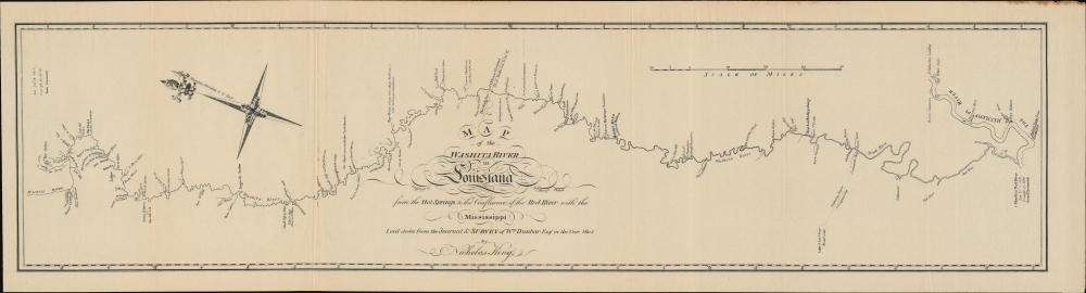
Map of the Washita River in Louisiana from the Hot Springs to the Confluence of the Red River with the Mississippi Laid down from teh Journal and Survey of Wm. Dunbar Esq. in the year 1804 by Nicholas King.
1904 (undated) 9.25 x 35 in (23.495 x 88.9 cm) 1 : 506880
1904 (undated) 9.25 x 35 in (23.495 x 88.9 cm) 1 : 506880
Description
A 1904 reprint of a nearly unobtainable 1804 original map of the Ouachita ('Washita') River in Louisiana and Arkansas. It was engraved by Nicholas King based on a survey undertaken by William Dunbar, who led an expedition to explore the southern portion of the Louisiana Territory, similar to Lewis and Clark's more famous expedition further north.
A Closer Look
This map is oriented towards the northeast and follows the course of the namesake river from the Hot Springs of the Ouachita Mountains, today in west-central Arkansas, southwards to where it splits into the Tensas (Bayou Tensa) and Black Rivers, with the latter linking it to the Red River and thereafter to the Mississippi not far from Dunbar's hometown of Natchez, Mississippi. Capturing the snakelike winding of these rivers, it denotes the famed hot springs, rapids, bayous, and islands along with features on land such as hills, prominent rocks, and trees. The border of the Orleans Territory (later the state of Louisiana) and the Louisiana Territory (later the Missouri Territory and then the state of Arkansas) is noted at center above the title. The settlement of 'Ft. Miro or Post of Washita' at center-right, established by the Spanish in 1781, is now Monroe, Louisiana.Hot Springs
The hot springs at left played an important part in the cultures of the region's Native Americans. Following Dunbar's Expedition, they became the object of curiosity and scientific attention in the young United States. In 1832, at the request of the legislature of the Arkansas Territory, Congress designated the springs as a protected 'reservation,' the first such designation, an important forerunner to the National Park System. Afterwards, the spa town of Hot Springs developed, attracting visitors from throughout the U.S.Publication History and Census
This map was engraved by Nicholas King based on a survey of William Dunbar in 1804, and reprinted by Houghton Mifflin and Co. in 1904 for the collection Documents Relating to the Purchase and Exploration of Louisiana, which was published in a limited run of 550 copies. The current map is independently cataloged among the holdings of Louisiana State University-Shreveport and the British Library, while the entire Documents is more widely distributed.CartographerS
Nicholas King (1771 - 1812) was an English-born artist, surveyor, and cartographer who played an important role in the early years of the American Republic. Born in Yorkshire to a father who was also a land surveyor, he left for New York in 1793 and soon moved to Philadelphia to take up work as a draughtsman and surveyor. In 1796, he moved to what would become Washington, D.C., where he undertook cadastral surveys of the city (he was a proponent of the original 1791 L'Enfant Plan for Washington, D.C.). In 1801, King was tasked by Albert Gallatin, Secretary of the Treasury, to produce a map of the Northwest Territory. Two years later, Gallatin asked him to produce a 'blank map' of the continent indicating the Mississippi River and Pacific Coast, for use on the Lewis and Clark Expedition. While the expedition was underway, King was dispatched to its winter camp at Fort Mandan to produce a set of maps based on the sketches of William Clark. He likewise produced maps of the southern portion of the Louisiana Territory (portions of present-day Louisiana, Arkansas, and Texas) from sketches of William Dunbar and the Curtis-Freeman Expedition. King was something of a polymath and inventor, and dabbled in politics and manufacturing late in his life. More by this mapmaker...
William Dunbar (1749 - 1810) was a Scottish-born businessman, surveyor, scholar, and explorer who played an important role in mapping the southern portion of the Louisiana Territory following the Louisiana Purchase. Born to an aristocratic family in Moray, Scotland, Dunbar was quiet and studious from an early age. He attended King's College in Aberdeen and was especially interested in natural sciences. As he was the fourth of his father's sons, he had few prospects in terms of inheritance, and sailed to America in 1771, settling in Philadelphia, to try his hand as a merchant. He then migrated to British West Florida and was granted land near Fort New Richmond (Baton Rouge). In 1784, he and his business partner established a large plantation near Natchez, Mississippi, where slaves primarily grew indigo and cotton. He acquired other lands in the vicinity and made additional income conducting surveys for the Spanish in Florida proper. He served as the Surveyor-General of West Florida in 1798. In 1800, he was elected to the American Philosophical Society and in his later years especially published works on a variety of topics including meteorology, astronomy, natural history, Native American languages, and American Sign Language. Through these endeavors, he gained the admiration of Thomas Jefferson, who in 1804 assigned Dunbar to lead a 15-man expedition to explore the southern portion of the Louisiana Purchase. Due to frictions with the Spanish and Native Americans, the journey had to be curtailed in its ambitions, the expedition explored the Red and Ouachita Rivers, produced the earliest detailed maps of the region, and collected a great deal of scientific data. Two years later, Dunbar was instrumental in planning a follow-up Red River Expedition (known as the Freeman-Custis Expedition), but was unable to join it himself due to poor health. Learn More...
Condition
Very good. Minor margin repair.
References
OCLC 557890004.