
1903 Veatch Map of Long Island, New York Waterworks Systems

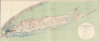
Map Showing the Waterworks Systems of Long Island, New York.
Supplying the City and Suburbs with Water.
- Digital Map Information
- Suitable for large format printing
- File Size: 88.83 MB
- File Type: ZIP / TIFF
- ICC color profile embedded
- Delivered instantly via download link
Supplying the City and Suburbs with Water.
This is a large-format 1903 map of Long Island by A.C. Veatch and Isaiah Bowman of the U.S. Geological Survey. It highlights the island's waterworks system, an essential factor in Long Island's rapid development in the early 20th century.A Closer Look
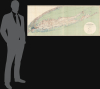
Measuring an impressive 62 inches long, the map covers all of Long Island, along with New York City and parts of New Jersey, Westchester County, and Connecticut. It charts the main components of the water supply system of Long Island, both the portions of New York City on the western part of the island and Nassau and Suffolk Counties on the central and eastern parts of the island. These include reservoirs and supply ponds, pumping stations, water mains, and standpipes. A color-coding system is employed to indicate ownership, municipal (New York City or otherwise) and private. Neighborhoods and towns are labeled throughout, as are waterways, rail lines, roads, islands, and other features, with elevation depicted with contour lines.Water Supply for a Growing City and Suburbs
In Brooklyn and Queens, which had officially become part of New York City (City of Greater New York) in 1898, the demand for water was exploding alongside the population. To keep pace, the city relied heavily on the Ridgewood Reservoir (at left here) and a sprawling network of brick conduits and pumping stations that tapped into the groundwater of southern Long Island. The 'Ridgewood System' drew from both surface ponds and deep wells, effectively sucking water from the Hempstead Plains to quench the thirst of the city. However, this dependence led to significant legal and environmental friction, as the massive pumping operations began to lower the water table, drying up local farms and streams in Nassau County.Further east, the waterworks were less centralized but no less vital to the island's development. While the western boroughs were beginning to look toward the Catskill Mountains for a more sustainable 'gravity-fed' solution to their water shortages, Nassau and Suffolk counties remained almost entirely dependent on aquifers. Private water companies and small municipal districts proliferated, drilling deeper into the glacial soil to access the pristine prehistoric water stored beneath the island. This period marked the transition from simple backyard wells to the sophisticated, high-capacity pumping infrastructure that characterizes Long Island's water management today.
Publication History and Census
This map was prepared in 1903 by Arthur Clifford Veatch of the U.S. Geological Survey, with assistance from Isaiah Bowman, and printed by Julius Bien and Company in New York. It appeared in the 1906 U.S.G.S. report Underground Water Resources of Long Island, New York co-written by Veatch and Bowman, among others. The map is independently cataloged among the holdings of Yale University, the Suffolk Cooperative Library System, Hofstra University, the Brooklyn Public Library, Cornell University, Stony Brook University, and the University of California, Berkeley.Cartographers
Arthur Clifford Veatch (October 26, 1878 - December 24, 1938) was an American geologist with a long career in the petroleum industry and with the U.S. Geological Survey. He was born in Evansville, Indiana and attended Indiana University, then Cornell University and the University of Wisconsin. His early career saw him working as a geologist in the oil industry in Texas in the booming years at the start of the 20th century, then take a teaching position at Louisiana State University. In 1902, he began working with the U.S. Geological Survey, where he took on a variety of tasks including exploring underground water resources and as a special commissioner to examine the mining laws of Australia and New Zealand. In 1910, he returned to the private sector, working in South America among other locations. He would lead the oil exploration efforts of the British petroleum firm Pearson and Son and later the Sinclair-Consolidated Oil Corporation, to the great benefit of both companies, before working independently as a consultant from 1928 onwards. Veatch was an active member in several professional and academic associations, including the American Association of Petroleum Geologists. Further Details...
Isaiah Bowman (December 26, 1878 - January 6, 1950) was an American geographer, academic administrator, and government official best known as the President of Johns Hopkins University and an advisor to President Franklin Roosevelt before and during the Second World War. Bowman was born in Waterloo, Ontario, Canada but his family moved to Michigan soon after his birth. After initially studying geography at Michigan State Normal College in Ypsilanti (now Eastern Michigan University), Bowman entered Harvard University, where he graduated in 1905, and then went on to graduate school at Yale University. Bowman showed impressive aptitude from an early stage in his career, including with administrative tasks, and became the first director of the American Geographical Society (AGS) when it was founded in 1915. Bowman rapidly expanded the organization and crafted a public role for it, advising the U.S. government and President Wilson on geographical matters in determining the aftermath of World War I in Europe. As 'Chief Territorial Specialist' for the U.S. delegation at the Paris Peace Conference, Bowman helped determine the contentious postwar borders of new nation-states, particularly in the Balkans. Having led the AGS for twenty years and continued an active program of research, Bowman was tapped to become president of Johns Hopkins University in 1935. By all accounts, he fixed the university's unfavorable financial situation, caused in large part by the Great Depression, though he also exhibited an intense Antisemitic streak, including the imposition of a 'Jewish quota' while most other prestigious universities were removing such quotas. Bowman continued a close association with the U.S. government, made easier by his proximity to Washington while at Johns Hopkins. In 1939, President Roosevelt tapped him to lead 'Project M,' designed to find places to settle Jewish refugees from Nazi Germany and elsewhere in Europe. Roosevelt chose Bowman for this job knowing of his Antisemitism, a sop to isolationists and Antisemites in his own party who did not want Jewish refugees to settle in the U.S. During the Second World War, Bowman championed the establishment of the Applied Physics Laboratory at Johns Hopkins, which developed important advances in weaponry that helped the war effort. In sum, Bowman was a giant of the geographical profession who did more than perhaps anyone else to define it in the early 20th century, but his legacy has been tarnished by his avowed and intransigent Antisemitism. Further Details...
The United States Geological Survey (1878 - Present), aka the U.S.G.S., is a scientific agency of the United States government, which was founded in 1879. USGS scientists study the landscape of the United States, its natural resources, and the natural hazards that threaten it. The organization has four major science disciplines: biology, geography, geology, and hydrology. It is a bureau of the United States Department of the Interior and is the department's only scientific agency. Further Details...
Julius (Julien) Bien (September 27, 1826 - December 21, 1909) was a German-Jewish lithographer and engraver based in New York City. Bien was born in Naumburg, Germany. He was educated at the Academy of Fine Arts, Cassell and at Städel's Institute, Frankfurt-am-Main. Following the suppression of the anti-autocratic German Revolutions of 1848, Bien, who participated in the pan-German movement, found himself out of favor in his home country and joined the mass German immigration to the United States. Bien can be found in New York as early as 1849. He established the New York Lithographing, Engraving & Printing Company in New York that focused on the emergent chromo-lithograph process - a method of printing color using lithographic plates. His work drew the attention of the U.S. Government Printing Office which contracted him to produce countless government maps and surveys, including the Pacific Railroad Surveys, the census, numerous coast surveys, and various maps relating to the American Civil War. Bien also issued several atlases both privately and in conjunction with a relation, Joseph Bien. At the height of his career Bien was elected president of the American Lithographers Association. After his death in 1909, Bien's firm was taken over by his son who promptly ran it into insolvency. The firm was sold to Sheldon Franklin, who, as part of the deal, retained the right to publish under the Julius Bien imprint. In addition to his work as a printer, Bien was active in the New York German Jewish community. He was director of the New York Hebrew Technical Institute, the New York Hebrew Orphan Asylum, and president of the B'nai B'rith Order. Further Details...
Source
Veatch, A. C. et al, Underground Water Resources of Long Island, New York, (U.S. Geological Survey / Government Printing Office: Washington, D.C.) 1906.
Condition
Very good. Light wear along original fold lines. Closed tear extending 2 inches into upper left quadrant quadrant not effecting any of the map professionally repaired on verso.
References
OCLC 45116674, 25208947.