This item has been sold, but you can get on the Waitlist to be notified if another example becomes available, or purchase a digital scan.
1794 Laurie Whittle Nautical Chart of West Africa
WestAfrica-lauriewhittle-1794$1,000.00


Title
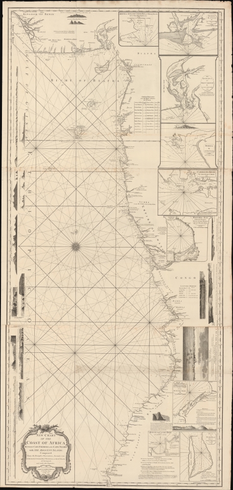
New Chart of the Coast of Africa between Cape Formoso and Cape Negro, with the Adjacent Islands.
1794 (dated) 61.25 x 29 in (155.575 x 73.66 cm) 1 : 1700000
1794 (dated) 61.25 x 29 in (155.575 x 73.66 cm) 1 : 1700000
Description
An intriguing 1794 nautical map of West Africa south of the Bite of Biafra. The chart was issued by Laurie and Whittle, but made for the African slave trade based on the detailed reports of prominent slavers and slave ship captains: Robert Norris, William Woodville, and Archibald Dalzel. It appeared at the height of the Triangle Trade, when countless Africans were captured and sold into captivity in the Americas. As such, the chart offers significant insights into the African Trade along central-west coasts.
As the trade increased, public outcry for abolition also increased. Around the time this map was issued, there was virulent debate in the British Parliament over slavery. Two of the three slave ship captains named here, Norris and Dalzel, testified before Parliament in support of the trade. After than two decades of debate, Parliament finally outlawed British involvement in the slave trade in 1807.
A Closer Look
Coverage embraces from the Bite of Biafra to Baia dos Tigres (Tigers Peninsula), today a desert island in southern Angola. A wealth of detail relevant to both the navigator and the slave trader line coast: names of indigenous African nations, sites of European factories, forts, and entrepôts, prominent landmarks, and annotations on the country and peoples. Some areas are called out specifically to slave traders, such as 'The Quesamas Rich in Slaves and Ivory' and further south 'Wild Negroes.' There are 9 large insets, some representing safe anchorages, most focusing on important slave ports. In addition, there are 22 coastal profile views.Historical Context
This chart appeared in the late 18th century, a period that marked both the peak of the Triangle Trade and the beginning of its decline. Although most European nations participated the foul commerce of slavery, the majority slave ship captains were British. Captains would sail to Africa from European ports, but most often Liverpool, where slaves were acquired from allied African nations - most the spoils of inter-tribal wars - then transported to the Americas, where they were sent to work in sugar and tobacco plantations. The slave ship captains would then load up on sugar, tobacco, fruits, cotton and other products before returning to Europe - restarting the wildly profitable cycle.As the trade increased, public outcry for abolition also increased. Around the time this map was issued, there was virulent debate in the British Parliament over slavery. Two of the three slave ship captains named here, Norris and Dalzel, testified before Parliament in support of the trade. After than two decades of debate, Parliament finally outlawed British involvement in the slave trade in 1807.
Publication History and Census
This map was issued both separately, and as part of Laurie and Whittle's 1794 The Africa Pilot being a collection of new and accurate charts, on a large scale, of the coasts, islands and harbours of Africa, from the Straits of Gibraltar to Cape Negro; including also the Atlantic and Southern Oceans. Very rare. We see but three cataloged examples: Biblioteca Nacional de España, the Bibliothèque nationale de France (BnF), and the Library of Congress. No history on the private market.CartographerS
Laurie and Whittle (fl. 1794 - 1858) were London, England, based map and atlas publishers active in the late 18th and early 19th century. Generally considered to be the successors to the Robert Sayer firm, Laurie and Whittle was founded by Robert Laurie (c. 1755 - 1836) and James Whittle (1757-1818). Robert Laurie was a skilled mezzotint engraver and is known to have worked with Robert Sayer on numerous projects. James Whittle was a well-known London socialite and print seller whose Fleet Street shop was a popular haunt for intellectual luminaries. The partnership began taking over the general management of Sayer's firm around 1787; however, they did not alter the Sayer imprint until after Sayer's death in 1794. Apparently Laurie did most of the work in managing the firm and hence his name appeared first in the "Laurie and Whittle" imprint. Together Laurie and Whittle published numerous maps and atlases, often bringing in other important cartographers of the day, including Kitchin, Faden, Jefferys and others to update and modify their existing Sayer plates. Robert Laurie retired in 1812, leaving the day to day management of the firm to his son, Richard Holmes Laurie (1777 - 1858). Under R. H. Laurie and James Whittle, the firm renamed itself "Whittle and Laurie". Whittle himself died six years later in 1818, and thereafter the firm continued under the imprint of "R. H. Laurie". After R. H. Laurie's death the publishing house and its printing stock came under control of Alexander George Findlay, who had long been associated with Laurie and Whittle. Since, Laurie and Whittle has passed through numerous permeations, with part of the firm still extant as an English publisher of maritime or nautical charts, 'Imray, Laurie, Norie and Wilson Ltd.' The firm remains the oldest surviving chart publisher in Europe. More by this mapmaker...
Robert Norris (1740 - November 27, 1791) was a British navigator, slave trader, and amateur historian active in the mid-18th century. Norris spent some eighteen years in the 'African Trade', as the slave trade was politely called, working the coasts of west Africa as an employee of the Royal African Company and a slave ship captain. Today several of his ship logs survive. He is best known for his work Memoirs of the Reign of Bosa Ahdee, King of Dahomy, an Anglo-centric and pro-slavery but insightful account of the rise and fall of a major west African kingdom. Although Norris was both a participant in and an ardent advocate for the deplorable trade, his work represents significant first-hand reporting and a unique look into the interior of an African Kingdom that was impenetrable to most Europeans. Norris' work was continued by his friend and colleague, Archibald Dalzel, whose larger History of Dahomey is heavily dependent upon Norris' research. From 1780 through 1791 he, along with Archibald Dalzel (1740 - 1818) testified before parliament in support of the slave trade. In reviewing Norris' testimony, the level of blatant dishonesty is shocking. He describes slaves as well cared for on slave ships, even citing them playing musical instruments, singing, and gambling throughout the voyages. Norris died in Liverpool in 1791, it is said, from a cold he contracted while sleeping on a damp mattress during his return from providing pro-slave trade testimony before Parliament in London. Learn More...
Archibald Dalzel (1740 - 1818) was a Scottish surgeon, slave trader, and historian active in the mid to late 18th century. Dalzel was born in Kirkliston, Scotland, and trained as a doctor in Edinburgh. He was in the employ of the African Company of Merchants from 1763 - 1770 and again from 1791 - 1802. He served the African Company as a surgeon at Anomabo on the Gold Coast. Afterwards, for about four years, he was governor of the Company of Merchants' fort at Whydah, Dahomey (Ouidah, Benin). Near the end of his term at Whydah, he traded with the Dahomey princes for a cargo of some 102 slaves, which he transported and sold in exchange for a promissory note. This note was never paid, and Dalzel was forced into bankrupts by 1773. He must have nonetheless recovered, as there are at least three ships under his name running the African slaver routes in the 1770s, the Little Archie, the Nancy, and the Hannah. He traded slaves under his own name until 1778, when a series of misfortunes, including a privateer attack, forced him again into bankruptcy. After a stint as a privateer himself, Dalzel began captaining slave ships for other owners. In the 1780s he represented the African Company, along with fellow slaver Robert Norris (1740 - 1791), in defending the trade against abolitionist efforts in Parliament. In 1791, he returned to the ful employ African Company, taking a post as governor of the Cape Coast Castle. He composed two books, a lengthy History of Dahomey, which included significant research by Robert Norris, and New Sailing Directions for the Coast of Africa (London, 1799). Learn More...
William Woodville (1744 - ????) was a Liverpool, England, based sea captain and slave trader who worked the Sierra Leone region and the African Windward Coast. His son, also William Woodville (June 10, 1763 - ????) was also a captain in the slave trade. Learn More...
Source
The Africa Pilot being a collection of new and accurate charts, on a large scale, of the coasts, islands and harbours of Africa, from the Straits of Gibraltar to Cape Negro; including also the Atlantic and Southern Oceans, (London: Robert Laurie and James Whittle), 1794.
Condition
Good. Three large sheets joined. Some edge wear and verso repairs where formerly folded.
References
OCLC 1339061481. Bibliothèque nationale de France, département Cartes et plans, GE SH 18 PF 109 P 23. Phillips (Atlases) 4802.