
1888 Bailey Bird's-Eye View Map of Westborough, Massachusetts

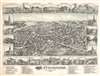
Westborough Massachusetts.
Largest bird's-eye view of Westborough.
- Digital Map Information
- Suitable for large format printing
- File Size: 60.92 MB
- File Type: ZIP / TIFF
- ICC color profile embedded
- Delivered instantly via download link
Largest bird's-eye view of Westborough.
A striking O. H. Bailey two-color chromolithograph bird's-eye view of Westborough, Massachusetts.A Closer Look
The view looks west on the town from a fictional highpoint (or he drew it from a balloon) roughly in the location of Cedar Swamp. The whole is notably more elaborate than most comparable views, highlighting Westborough's significance and prosperity. The central view is surrounded by 22 framed illustrations of significant structures, ranging from churches and municipal buildings to enormous factories and the stately homes of the local elite. The Lyman School for Boys, the first reform school in the United States, appears in the upper right. At the base of the map a table identifies some 51 locations corresponding to numbers on the view.American Bird's-Eye City Views
The tradition of the bird's-eye city view emerged in the United States in the middle part of the 19th century and coincided with the commercial development of lithographic printing. While before the rise of lithography, the ability to own and display artwork in the home was largely limited to the extremely wealthy, lithographic printing made it possible for everyone to own visually striking artwork. A robust trade developed in portraits of political leaders, allegorical and religious images, and city views.City views were being produced in the United States as early as the 1830s, but the genre exploded after the American Civil War (1861 - 1865). Bridging the gap between maps and pictures, most 19th century American Bird's-eye views presented cities to the public high vantage points. Some were imagined, but others were drawn from hot-air balloons or nearby hills. The presentation, combining high elevation, commercial interest, and new printing technology created a uniquely American art form, as described by historian Donald Karshan,
Some print connoisseurs believe that it was only with the advent of the full-blown city-view lithograph that American printmaking reached its first plateau of originality, making a historical contribution to the graphic arts. They cite the differences between the European city-view prints and the expansive American version that reflects a new land and a new attitude toward the land.The vogue for bird's-eye city views lasted from about 1845 to 1920, during which period some 2,400 cities were thus portrayed, some multiple times. Although views were produced in many urban centers, the nexus of view production in the United States was Milwaukee, Wisconsin. The major American viewmakers were Stoner, Wellge, Bailey, Fowler, Hill, Ruger, Koch, Burleigh, Norris, and Morse, among others.
Chromolithography
Chromolithography is a color lithographic technique developed in the mid-19th century. The process involved using multiple lithographic stones, one for each color, to yield a rich composite effect. Oftentimes, the process would start with a black basecoat upon which subsequent colors were layered. Some chromolithographs used 30 or more separate lithographic stones to achieve the desired product. Chromolithograph color could also be effectively blended for even more dramatic results. The process became extremely popular in the late 19th and early 20th centuries, when it emerged as the dominate method of color printing. The vivid color chromolithography produced made it exceptionally effective for advertising and propaganda imagery.Publication History and Census
This view was drawn and published in Boston in 1888 by Oakley Hoopes Bailey. It is the second and largest of two known views of Westborough - the first having been published in 1880 by Beck and Pauli. Reps identifies examples at the Massachusetts State Library, the Boston Public Library, and the American Antiquarian Association. We note an additional example at the Library of Congress.Cartographer
Oakley Hoopes Bailey (June 14, 1843 - August 13, 1947) was a prolific American viewmaker, artist, and lithographer active in the late 19th and early 20th centuries. Bailey was born in Beloit, Mahoning County, Ohio. He matriculated in 1861 at Mount Union College in Alliance, Ohio, where he studied architecture. At the outbreak of the American Civil War (1861 - 1865), he briefly abandoned his studies for 2 years, during which time he saw combat as a Union soldier. After the war, in 1866, he returned to Mount Union to complete his degree. Bailey was the younger brother of another view artist, Howard Heston Bailey (1836 - 1878), and followed his brother into the print business, producing his first city views of Milwaukee, Wisconsin, in 1871. Active from 1871 to 1926, Bailey produced more than 375 recorded city views across more than 13 states and 2 Canadian provinces, making him one of the most active viewmakers in American history. In 1875, he settled in Cambridge, Massachusetts, and most of his subsequent work focused on Massachusetts and Connecticut. Bailey worked with many other American viewmakers of the period, including his brother, Howard Heston Bailey, Thaddeus M. Flower, and J. C. Hazen, among others. Even his wife, Sarah F. Bailey (1846 - 19??), got into the business, drawing at least one view of Watkins Glen, New York. Around 1904, in his 60s, Bailey entered a publishing partnership with Thomas S. Hughes, publishing their 'Aero-Views' as 'Hughes and Bailey'. Together, Hughes and Bailey revisited many of Bailey's early view sites, remaking them sometimes 20-40 years later, with the idea of setting them beside the earlier views to show how much the towns had changed. The partnership lasted until about 1926. Bailey died in his hometown of Alliance at the ripe old age of 103. Further Details...
Condition
Good. Some minor repaired and reinforced margin tears. Repaired and reinforced tear extending from right side roughly 5 inches into the sheet. Stabilized.
References
Reps, John, Views and Viewmakers of Urban America (University of Missouri, Columbia, 1984), #1678. OCLC 30387664. Boston Public Library, G3764.W56A3 1888 .O43.