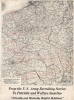
1920 Army Recruiting Service Map of the Western Front
WesternFront-armyrecruitingservice-1920$1,800.00


Title
From the U.S. Army Recruiting Service to Patriotic and Welfare Societies.
1920 (dated) 31.5 x 23 in (80.01 x 58.42 cm) 1 : 530000
1920 (dated) 31.5 x 23 in (80.01 x 58.42 cm) 1 : 530000
Description
A striking 1920 map of the Western Front of World War I (1914 - 1918), noting the locations of campaigns and battles in which American forces fought. It was produced by the U.S. Army's Engineer Reproduction Plant, apparently as a guide for distributing medals and clasps to veterans of the conflict.
A Closer Look
Coverage includes nearly the entire Western Front from the English Channel to the St. Mihiel salient, site of a successful American attack in September 1918. Major operations of the American Expeditionary Force are named with their dates recorded, and are divided into offensives, denoted with solid lines, and defensives, indicated by dashed lines. The Battle Line as of November 11, 1918, stands out at right, highlighting the rapid advances of Allied troops in the final weeks of the war.Victory Medals
Victory medals and similar service medals were given out to victorious Allied troops in the months and years following the end of the conflict, with variations by country but some common features, such as the multicolored ribbon, the winged figure of Victory, and the phrase 'The Great War For Civilization.' The 'Patriotic and Welfare Societies' mentioned at bottom likely refer to the American Legion, Veterans of Foreign Wars, and other veterans' organizations, for whom a victory medal was as good as a membership card. It is likely that the map originally was produced by the Army for determining the distribution of medals and clasps to veterans, and then was reissued as part of this broadside that was distributed to veterans' organizations to commemorate the conflict.Publication History and Census
This map was produced by the U.S. Army's Engineer Reproduction Plant, a forerunner to the Army Map Service in 1920. We have been unable to locate any other examples either in institutional collections or on the market, though one example of a very similar map is held by the University of Tulsa McFarlin Library's special collection of World War I posters (Identifier: 1992.004.5.6.2.4).Condition
Fair. Minor areas of loss in margins professionally repaired with infill. Backed on tissue.