This item has been sold, but you can get on the Waitlist to be notified if another example becomes available, or purchase a digital scan.
1852 Cruchley Map of the Western Hemisphere
WesternHemisphere-cruchley-1853$100.00

Title
The Western Hemisphere.
1852 (dated) 15 x 15 in (38.1 x 38.1 cm) 1 : 58000000
1852 (dated) 15 x 15 in (38.1 x 38.1 cm) 1 : 58000000
Description
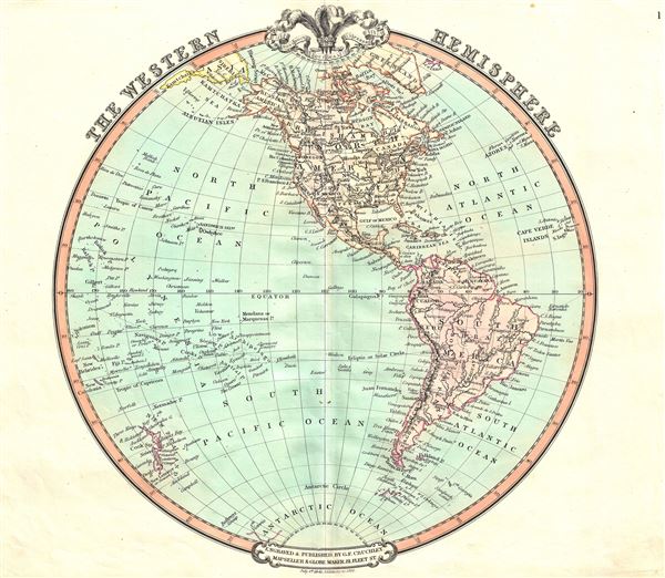
A beautiful 1852 George Frederick Cruchley map of the Western Hemisphere. It offers a fascinating snapshot of the world during a period of rapid globalization and discovery, and includes North America, South America and most of Polynesia. Antarctica is only tenuously denoted, reflecting the primitive state of exploration in the region. The map is color coded according to continents with countries, major cities, rivers, mountains and other topographical features noted. Relief is shown by hachures.
The 1850s were a period of both great hope and simmering tensions in the United States. With the end of the Mexican American War and the signing of the 1848 Treaty of Guadalupe Hidalgo, the United States acquired vast new territories. The discovery of gold in California in 1849 initiated and mass trans-continental emigration in the quest for wealth and land. California was admitted as the 31st state in September of this year and the cities of Los Angeles and San Francisco were incorporated. Meanwhile, tensions continued to rise between the slave holding agrarian southern states and the industrialized 'free' northern states. The Compromise of 1850, intended to placate the slave holding states, essentially divided the United States along lines that, by 1861, would degenerate in the American Civil War.
Meanwhile, much of South America was, at this time, embroiled in or was about to become embroiled in, severe civil strife. The new nations, freed from Spanish dominance though various wars of liberation in the previous decades, were struggling with their newfound independence in an attempt to create stable and prosperous governments. Most would dissolve into civil war between 1858 and 1864.
Cruchley's General Atlas was unique for its period, employing a vivid color scheme extending even to the oceans, distinctive typography, and various uncommon decorative elements including a peacock feather crown and an imprint medallion, both of which break the printed border. Though many of the maps in this atlas are copyrighted in 1841, the atlas was first published in 1843 from the Cruchley office at 81 Fleet Street, London, and proving popular went through numerous reissues well into the 1850s.
Cartographer
George Frederick Cruchley (April 23, 1797 - June 16, 1880) was a London based book and map seller active in the middle part of the 19th century. Cruchley began his cartographic career as an apprentice at the venerable Aaroon Arrowsmith firm. Many of Cruchley's earliest maps bear the words 'From Arrowsmith's' on the imprint. In 1844, Cruchley acquired the massive stock of the important early 19th century firm of John Cary. Cruchley published his own maps as well as reissues of Cary's stock well into the 1870s. He is best known for his detailed plans of London, which in recent years have become increasingly scarce and desirable. Cruchley was based in London on 38 Ludgate Street until 1834 when he moved his offices to 81 Fleet Street. Shortly before his death in 1880 Cruchely auctioned (Hodgson's Auctions, Jan 16, 1877) his entire stock. Many of his map plates were thusly acquired by 'Gall and Inglis' who continued the Cruchley tradition well into the early 20th century. Cruchley's son, also George Frederick (1837 - 1882), continued to work as a book and map seller until his death. More by this mapmaker...
Source
Cruchley, G. F., Cruchley's General Atlas, for the use of Schools and Private Tuition, London, 1853.
Condition
Very good. Minor wear along original centerfold. Blank on verso.