This item has been sold, but you can get on the Waitlist to be notified if another example becomes available, or purchase a digital scan.
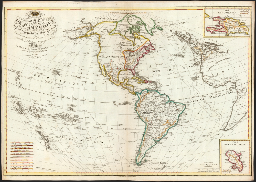
1795 Hérisson Map of North America and South America
WesternHemisphere-herisson-1795$2,000.00


Title
Carte de l'Amérique Septentrionale et Meridionale, ou se trouvent les Decouvertes les plus nouvelles, et les trois Voyages de Cook Dressée Par Hérisson, E lève du C.en Bonne, ancien Ingénieur Hydrographe de la Marine. A Paris, Chez Basset, rue Jacques, au coin de celle des Mathurins, No. 670.
1795 (dated) 20.5 x 30.25 in (52.07 x 76.835 cm) 1 : 30000000
1795 (dated) 20.5 x 30.25 in (52.07 x 76.835 cm) 1 : 30000000
Description
This is a rare, elegant, and detailed map of America by Eustache Hérisson, in its 1795 first edition. In addition to the Western Hemisphere, Hérisson's work focuses on the three voyages of Captain James Cook - in particular, presenting the key results of his third and final journey to Hawaii, and his efforts to penetrate the Bering Straits. Cook's tracks through the Pacific and the Atlantic both are included. His journey through the South Pacific, its revelations of New Zealand, and the cipher presented by the as-yet undetected Antarctica are also made evident.
The western expanse of North America - from New Mexico right up to the arctic Mer Glaciale, and from the Mississippi to the Pacific - is presented as a vacant expanse. At the rim of this open space are marked suspected water passages, as well as the names of known Native American tribes along its frontiers.
Scope of the Map
The map extends from 80º north to 70º south, thus covering from the Arctic beyond Baffin's Bay to just south of Tierra del Fuego. To the east, much distorted by the projection, are the Atlantic coastlines of Africa and Europe. The western limits include New Zealand to the south, the Marshall Islands due west, and in the extreme north the Asian coastline abutting the Bering Strait and the Aleutian Islands. Inset maps in the upper and lower right detail the islands of Santo Domingo or Hispaniola, and Martinique, respectively. Beside the Martinique detail, a key describes the dotted-line scheme differentiating the tracks for Cook's three voyages. An elaborate set of scales in the lower left offers the measure for distances in ten standards of miles and leagues.A Vacant Northwest
In addition to Cook's sea voyages, Samuel Hearne's 1772 Canadian overland journey from Hudson's Bay to the Arctic mouth of the Coppermine River is marked; while this expedition proved the nonexistence of a northwest passage connected to Hudson's Bay, this work nevertheless retains the imaginary channel (alleged to exist in 1768 by Alexander Cluny) which had spurred the Hearne expedition in the first place.The western expanse of North America - from New Mexico right up to the arctic Mer Glaciale, and from the Mississippi to the Pacific - is presented as a vacant expanse. At the rim of this open space are marked suspected water passages, as well as the names of known Native American tribes along its frontiers.
An Extremely General Map of the United States
Here printed with a dotted line border, and with red outline coloring, is the newly-minted United States; its borders extend west to the Mississippi - but well north of the Saint Lawrence River, encompassing a large part of British Canada. In spite of the Mississippi border, the French place name Louisiane extends well east, encroaching on the Appalachian Mountains.Beyond North America
Beyond the Arctic and North America, the map offers additional items of interest. South America is shown in reasonable detail: Lake Parima, mythical site of El Dorado from the 15th century, is here correctly associated with Lake Amuku, in Guyana. Lake Xarayes, another speculative El Dorado, remains at the northern terminus of the Paraguay River.Publication History and Census
Hérisson first published this map in 1795, in conjunction with his mentor Rigobert Bonne. It was printed in Paris by Chez Basset. The map was available as a separate issue, as well as in a bound 'atlas' of five maps sold by Desnos. We are aware of amended editions of 1806, 1817 and 1819; a later, expanded 1833 edition printed from a much larger plate. We see four examples of the present 1795 edition listed separately: Johan Christian Library in Senckenberg, the Sachsische Landesbibliothek, the Paris Museum of Natural History, and the University of Michigan. One example of the 1795 atlas is held by the National Library of Australia. The map is rare on the market.CartographerS
Eustache Hérisson (1759 – 1818) was a French cartographer and geographical engineer active in Paris during the early years of the 19th century. Hérisson was a student of the 18th century hydrography Rigobert Bonne. He was a member of the Société Royale. Much of his work was republished posthumously by Bassett, Brue, and others. More by this mapmaker...
Maison Basset (1819 - 1865) was a French publishing concern active through the mid to late 19th century. The firm can trace their roots to André Basset (Bassett; fl. 1768 - 1784), who starting publishing maps, prints, and books around 1768. Maison Basset, also Chez Basset, is the imprint under which the heirs of Paul-André Bassett (1759 - 1829) operated after his death. From their offices at 64 Rue St. Jacques, then 33 Rue de Seine, Paris, France, Maison Basset published the works of such prominent French cartographers and engravers as Barbie du Bocage, A. Vuillemin, J. B. Charle, V. Levasseur, Tu. Duvotenay, H. Dufor, F. E. George, and others. Their library of publications is diverse and vast, but heavily focused on medical and scientific texts, including several important atlases. The firm is closely aligned with the Chéreau family of printers and engravers, with whom they were connected with multiple, often incestuous, marriages and remarriages. Learn More...
Rigobert Bonne (October 6, 1727 - September 2, 1794) was one of the most important French cartographers of the late 18th century. Bonne was born in Ardennes à Raucourt, France. He taught himself mathematics and by eighteen was a working engineer. During the War of the Austrian Succession (1740 - 1748) he served as a military engineer at Berg-op-Zoom. It the subsequent years Bonne became one of the most respected masters of mathematics, physics, and geography in Paris. In 1773, Bonne succeeded Jacques-Nicolas Bellin as Royal Cartographer to France in the office of the Hydrographer at the Depôt de la Marine. Working in his official capacity, Bonne compiled some of the most detailed and accurate maps of the period - most on an equal-area projection known erroneously as the 'Bonne Projection.' Bonne's work represents an important step in the evolution of the cartographic ideology away from the decorative work of the 17th and early 18th century towards a more scientific and practical aesthetic. While mostly focusing on coastal regions, the work of Bonne is highly regarded for its detail, historical importance, and overall aesthetic appeal. Bonne died of edema in 1794, but his son Charles-Marie Rigobert Bonne continued to publish his work well after his death. Learn More...
Source
Desnos, L., Atlas compose de la mappemonde, l'Europe, l'Asie, l'Afrique et l'Amerique, ou sont marquees exactement les decouvertes les plus recentes et les routes des trois derniers voyages du Capitaine Cook, (Paris: Malherbe) 1795.
Condition
Very good. Two unobtrusive spots, else excellent.
References
OCLC 78731287.