This item has been sold, but you can get on the Waitlist to be notified if another example becomes available, or purchase a digital scan.
1873 Stieler's Map of the Western Hemisphere
WesternHemisphere-stieler-1873$85.00

Title
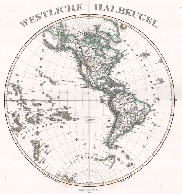
Westliche Halbkugel
1873 12.5 x 11.5 in (31.75 x 29.21 cm)
1873 12.5 x 11.5 in (31.75 x 29.21 cm)
Description
This superb map is a copperplate engraving, dating to 1873 by the famed German mapmaker Adolf Stieler, describing the Western hemisphere. All national and political boundaries are clearly outlined in vibrant color. Further, all notable mountains, swamps, passes, islands, and bodies of water are labeled. All labels are in German. This map is signed Gotha Justus Perthes and dated 1873. This stunning map is a copper platecolor engraving with a deep indicative platemark in the wide outer margins. It is exceedingly and precisely detailed. Each major region is carefully outlined in hand applied color washes. Stieler's maps, particularly those from the 1870s are renowned for their impressive attention to detail. Every aspect of the terrain, from mountains and river to political boundaries are precisely described. Some Stieler's map even indicate relative ocean depths and submarine geography. Printed on only the highest quality paper, Stieler's maps were made to last.
Cartographer
Johan Georg Justus Perthes (September 11, 1749 - May 2, 1816) was one of the most important German cartographic engravers of the 19th century. He was born in the Thuringian town of Rudolstadt, the son of a court physician. In 1778, he began working as a bookseller in Gotha. Perthes began his publishing empire shortly thereafter with the 1784 issue of the famed survey of European nobility known as the Almanac de Gotha. In the next year, 1785, he founded the cartographic firm of Justus Perthes Geographische Anstalt Gotha. His son Wilhelm Perthes (1793 - 1853) joined the firm in 1814. Wilhelm had prior publishing experience at the firm of Justus Perthes' nephew, Friedrich Christoph Perthes, who ran a publishing house in Hamburg. After Justus Perthes died in 1816, Wilhelm took charge and laid the groundwork for the firm to become a cartographic publishing titan. From 1817 to 1890. the Perthes firm issued thousands of maps and more than 20 different atlases. Along with the visionary editors Hermann Berghaus (1797 - 1884), Adolph Stieler (1775 - 1836), and Karl Spruner (1803 - 1892), the Perthes firm pioneered the Hand Atlas. When Wilhelm retired, management of the firm passed to his son, Bernhardt Wilhelm Perthes (1821 – 1857). Bernhardt brought on the cartographic geniuses August Heinrich Peterman (1822 - 1878) and Bruno Hassenstein (1839 - 1902). The firm was subsequently passed to a fourth generation in the form of Berhanrd Perthes (1858 – 1919), Bernhard Wilhelm's son. The firm continued in the family until 1953 when, being in East Germany, it was nationalized and run as a state-owned enterprise as VEB Hermann Haack Geographisch-Kartographische Anstalt Gotha. The Justus family, led by Joachim Justus Perthes and his son Wolf-Jürgen Perthes, relocated to Darmstadt where they founded the Justus Perthes Geographische Verlagsanstalt Darmstadt. More by this mapmaker...
Condition
Very good condition. Original centerfold. Blank on verso.