
1904 U.S.G.S. Map of Water Table on Long Island, New York

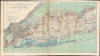

Map showing the Position of the Main Ground-water Table on Long Island, New York.
Water Supply for the Great Metropolis.
- Digital Map Information
- Suitable for large format printing
- Full resolution TIFF file
- ICC color profile embedded
- Delivered instantly via download link
Water Supply for the Great Metropolis.
This is a 1904 map of the groundwater table and water supply infrastructure on western Long Island produced by the U.S. Geological Survey. Part of the effort to map Long Island's water resources, it addressed a critical need for information as the water demands of the rapidly growing New York City increased.A Closer Look
The map covers from portions of Westchester County, Bronx, Manhattan, New Jersey, and Staten Island in the west to Port Jefferson and Patchogue in the east, taking in Nassau and roughly half of Suffolk County as well as Brooklyn and Queens. Contour lines indicate elevation above ground and the water table below. Other lines trace groundwater and surface divides, while wells are marked with small circles. The street grid of New York and adjacent communities is drawn, while rail lines and country roads are also traced. Neighborhoods and towns are labeled throughout.Water Supply for a Growing City and Suburbs
This map was part of a U.S.G.S. study on the 'Underground Water Resources of Long Island, New York,' the result of several years of work by a team led by A. C. Veatch, which was prompted by New York City's growing need for a reliable water supply (see also our related offering, WaterworksLongIsland-veatch-1903). In Brooklyn and Queens, which had officially become part of New York City (City of Greater New York) in 1898, the demand for water was exploding alongside the population. To keep pace, the city relied heavily on the Ridgewood Reservoir (at left here) and a sprawling network of brick conduits and pumping stations that tapped into the groundwater of southern Long Island. This 'Ridgewood System' drew from both surface ponds and deep wells, effectively sucking water from the Hempstead Plains to quench the thirst of the city. However, this dependence led to significant legal and environmental friction, as the massive pumping operations began to lower the water table, drying up local farms and streams in Nassau County.Further east, the waterworks were less centralized but no less vital to the island's development. While the western boroughs were beginning to look toward the Catskill Mountains for a more sustainable 'gravity-fed' solution to their water shortages, Nassau and Suffolk Counties remained almost entirely dependent on aquifers. Private water companies and small municipal districts proliferated, drilling deeper into the glacial soil to access the pristine, prehistoric water stored beneath the island. This period marked the transition from simple backyard wells to the sophisticated, high-capacity pumping infrastructure that characterizes Long Island's water management today.
Publication History and Census
This map was prepared by the U.S. Geological Survey in 1904 for inclusion in the aforementioned report, which was published by the Government Printing Office in 1906. The map is independently cataloged at the University of California Berkeley, the Denver Public Library, the Brooklyn Public Library, and Yale University in the OCLC.Cartographers
The United States Geological Survey (1878 - Present), aka the U.S.G.S., is a scientific agency of the United States government, which was founded in 1879. USGS scientists study the landscape of the United States, its natural resources, and the natural hazards that threaten it. The organization has four major science disciplines: biology, geography, geology, and hydrology. It is a bureau of the United States Department of the Interior and is the department's only scientific agency. Further Details...
Julius (Julien) Bien (September 27, 1826 - December 21, 1909) was a German-Jewish lithographer and engraver based in New York City. Bien was born in Naumburg, Germany. He was educated at the Academy of Fine Arts, Cassell and at Städel's Institute, Frankfurt-am-Main. Following the suppression of the anti-autocratic German Revolutions of 1848, Bien, who participated in the pan-German movement, found himself out of favor in his home country and joined the mass German immigration to the United States. Bien can be found in New York as early as 1849. He established the New York Lithographing, Engraving & Printing Company in New York that focused on the emergent chromo-lithograph process - a method of printing color using lithographic plates. His work drew the attention of the U.S. Government Printing Office which contracted him to produce countless government maps and surveys, including the Pacific Railroad Surveys, the census, numerous coast surveys, and various maps relating to the American Civil War. Bien also issued several atlases both privately and in conjunction with a relation, Joseph Bien. At the height of his career Bien was elected president of the American Lithographers Association. After his death in 1909, Bien's firm was taken over by his son who promptly ran it into insolvency. The firm was sold to Sheldon Franklin, who, as part of the deal, retained the right to publish under the Julius Bien imprint. In addition to his work as a printer, Bien was active in the New York German Jewish community. He was director of the New York Hebrew Technical Institute, the New York Hebrew Orphan Asylum, and president of the B'nai B'rith Order. Further Details...
Arthur Clifford Veatch (October 26, 1878 - December 24, 1938) was an American geologist with a long career in the petroleum industry and with the U.S. Geological Survey. He was born in Evansville, Indiana and attended Indiana University, then Cornell University and the University of Wisconsin. His early career saw him working as a geologist in the oil industry in Texas in the booming years at the start of the 20th century, then take a teaching position at Louisiana State University. In 1902, he began working with the U.S. Geological Survey, where he took on a variety of tasks including exploring underground water resources and as a special commissioner to examine the mining laws of Australia and New Zealand. In 1910, he returned to the private sector, working in South America among other locations. He would lead the oil exploration efforts of the British petroleum firm Pearson and Son and later the Sinclair-Consolidated Oil Corporation, to the great benefit of both companies, before working independently as a consultant from 1928 onwards. Veatch was an active member in several professional and academic associations, including the American Association of Petroleum Geologists. Further Details...
Source
Veatch, A. C. et al, Underground water resources of Long Island, New York (U.S.G.S. Professional Paper No. 44) (Washington, D.C.: Government Printing Office, 1906).
Condition
Good. Some toning along folds and along edge.
References
OCLC 47782508.