
1854 Colton Pocket Map of the American Midwest, incl. Minnesota Territory

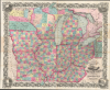
Colton's Railroad and Township Map Western States compiled from the United States Surveys. / Map of the Western States.
Settling the Upper Midwest.
- Digital Map Information
- Suitable for large format printing
- File Size: 121.82 MB
- File Type: ZIP / TIFF
- ICC color profile embedded
- Delivered instantly via download link
Settling the Upper Midwest.
This is a lovely, decorative, large-format 1854 pocket map of the American Midwest by Joseph H. Colton. It captures the region in the years before the U.S. Civil War and is notable for including Minnesota as a territory as well as demonstrating the rapid expansion of railroads throughout the Midwest.A Closer Look
This stunning hand-colored map covers the 'Western States' of Ohio, Kentucky, Michigan, Indiana, Illinois, Wisconsin, Iowa, and Missouri, as well as a truncated Minnesota Territory and portions of the surrounding territory. Counties are color-shaded for easy distinction and subdivided by survey lines, while states and territories are outlined in thick red lines. Railroad lines (existing and proposed), roads, waterways (including canals), cities, villages, forts, Native American tribes and settlements, trading posts, and other features are recorded throughout. Vignette views of Cincinnati, Louisville, and St. Louis appear, along with illustrations of a buffalo and deer in the top corners.Historical Context
The detail provided here is eminently useful for tracing the evolution of frontier settlement and the railway network of the United States in this period. A quick comparison with maps from just a handful of years earlier (such as Phelps 1848 'National Map,' previously sold by us as UnitedStates-phelps-1848, or even Andrews' Railroad Map of the U.S. from just two years prior, UnitedStates-andrews-1852), clearly reveals the rapid changes taking place year-by-year.Here, much of the Upper Midwest remains sparsely populated and even unsurveyed. While states like Illinois, Indiana, and even southern Wisconsin are crisscrossed by railroads, with more on the way, Minnesota - already a territory for five years at this point - contains only a single road along the Mississippi River and lacks railroads entirely. It is partially surveyed around St. Paul and the future site of Minneapolis (Falls of St. Anthony) but otherwise remains unsurveyed.
Publication History and Census
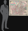
This map was prepared by J. H. Colton in 1854 and printed by David McLellan in New York City. It is derived from Colton and Calvin J. Smith's wall map of the U.S. ('Colton's Map of the United States of America Including Canada and a Large Portion of Texas') issued the same year, and also is very likely related to a map issued the previous year by frequent Colton collaborators Atwood and Thayer (see our WesternStates-atwood-1853), although the present map is larger and more comprehensive. Colton issued this pocket map of the Western States annually between 1853 and 1857, all of which are quite scarce now. The present edition was issued in two sizes, one somewhat smaller (29 x 35.5 in.) and the present larger printing (35.5 x 43.25 in.). Catalog listings co-mingle both printings, as well as digital and physical examples of the map, but physical examples of the pocket map in either size are listed among the holdings of perhaps ten institutions in the OCLC.Cartographers
Joseph Hutchins Colton (July 5, 1800 - July 29, 1893), often publishing as J. H. Colton, was an important American map and atlas publisher active from 1833 to 1897. Colton's firm arose from humble beginnings when he moved to New York in 1831 and befriended the established engraver, Samuel Stiles. He worked under Stiles as the 'Co.' in Stiles and Co. from 1833 to 1836. Colton quickly recognized an emerging market in railroad maps and immigrant guides. Not a cartographer or engraver himself, Colton's initial business practice mostly involved purchasing the copyrights of other cartographers, most notably David H. Burr, and reissuing them with updated engraving and border work. His first maps, produced in 1833, were based on earlier Burr maps and depicted New York State and New York City. Between 1833 and 1855, Colton proceeded to publish a large corpus of guidebooks and railroad maps, which proved popular. In the early 1850s, Colton brought his two sons, George Woolworth Colton (1827 - 1901) and Charles B. Colton (1832 - 1916), into the map business. G. W. Colton, trained as a cartographer and engraver, was particularly inspired by the idea of creating a large and detailed world atlas to compete with established European firms for the U.S. market. In 1855, G.W. Colton issued volume one of the impressive two-volume Colton's Atlas of the World. Volume two followed a year later. Possibly because of the expense of purchasing a two-volume atlas set, the sales of the Atlas of the World did not meet Colton's expectations, and so, in 1856, the firm also issued the atlas as a single volume. The maps contained in this superb work were all original engravings, and most bear an 1855 copyright. All of the maps were surrounded by an attractive spiral motif border that would become a hallmark of Colton's atlas maps well into the 1880s. In 1857, the slightly smaller Colton's General Atlas replaced the Atlas of the World. Most early editions of the General Atlas published from 1857 to 1859 do not have the trademark Colton spiral border, which was removed to allow the maps to fit into a smaller format volume. Their customers must have missed the border because it was reinstated in 1860 and remained in all subsequent publications of the atlas. There were also darker times ahead; in 1858, Colton was commissioned at a sum of 25,000 USD by the government of Bolivia to produce and deliver 10,000 copies of a large format map of that country. Although Colton completed the contract in good faith, delivering the maps at his own expense, he was never paid by Bolivia, which was at the time in the midst of a series of national revolutions. Colton would spend the remainder of his days fighting with the Bolivian and Peruvian governments over this payment, and in the end, after a congressional intervention, he received as much as 100,000 USD in compensation. Nonetheless, at the time, it was a disastrous blow. J. H. Colton and Company is listed as one of New York's failed companies in the postal record of 1859. This led Colton into the arms of Alvin Jewett Johnson and Ross C. Browning. The 1859 edition of Colton's General Atlas lists Johnson and Browning as the 'Successor's to J. H. Colton' suggesting an outright buyout, but given that both companies continued to publish separately, the reality is likely more complex. Whatever the case may have been, this arrangement gave Johnson and Browning access to many of Colton's map plates and gave birth to Johnson's New Illustrated (Steel Plate) Family Atlas. The Johnson's Atlas was published parallel to Colton's atlases well into the 1880s. The Colton firm itself subsequently published several other atlases including an Atlas of America, the Illustrated Cabinet Atlas, the Octavo Atlas of the Union, and Colton's Quarto Atlas of the World. They also published a large corpus of wall maps, pocket maps, and guides. The last known publications of the Colton firm date to 1897 and include a map and a view, both issued in association with the Merchant's Association of New York. Alice M. Colton married August R. Ohman (May 3, 1859 - April 22, 1934) on January 5, 1897. In 1898, Ohman joined the Colton firm, which continued to publish as Colton, Ohman & Co. until 1901. Further Details...
David McLellan (September 20, 1825 - July 26, 1867) was a Scottish-American lithographer and printer active in New York City in the middle part of the 19th century. McLellan was born Pollockshaws, Renfrewshire, Scotland. He lived in Glasgow for about 20 years, where he mastered printing and lithography under his father James McLellan (1798 - 18??). In 1847, he immigrated to New York City with his brother, James McLellan. David initially printed under his own name, 'David McLellan (1851 - 1854), the with in partnership with his brother, James, as 'D and J. McLellan' (1855 - 1860), and then again under his own name during the Civil War from 1862 -1863, then as 'David McLellan and Brothers' (1864 - 1866). He joined the mostly Scottish 79th 'Highlander' Regiment, with whom he participated with the rank of 'Major' in the American Civil War (1862 - 1865). During his long career as a New York lithographer, McLellan worked with many prominent publishers, including J. H. Colton, Edward Valois, James Ackerman, the U.S. Coast Surrey. After his death in 1867 he was interred in Greenwood Cemetery. The McLellan printing business continued after his death under the imprint of John McLellan (1867 - 1868) and J. (John) and R. (Robert) McLellan (1869). No further McLellan work is known after 1869. Further Details...
Condition
Very good. Minor discolorations along old fold lines and were originally folded against the binder. Archival tissue reinforcement on verso at most fold intersections.
References
Rumsey 4985. OCLC 78686227, 953568834. Karrow 1-0852. Library of Congress, Map Division, G4061.P3 1853 .C6 Fil 59. American Antiquarian Society, Box 3. Library of Congress, Railroad maps, 147a. Kentucky Historical Society, Map Collection, khs.map.87.