1805 Cary Map of the Great Lakes and Western Territory (Kentucy, Virginia, Ohio, etc..)
WesternTerritory-cary-1805-2$1,200.00

Title
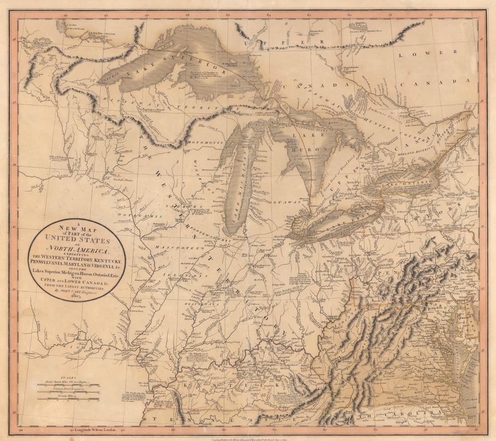
A New Map of Part of the United States of North America, exhibiting The Western Territory, Kentucky, Pennsylvania, Maryland, Virginia and C. Also, the Lakes Superior, Michigan, Huron, Ontario and Erie; with Upper and Lower Canada and C. From the Latest Authorities.
1805 (dated) 18 x 20.25 in (45.72 x 51.435 cm) 1 : 3300000
1805 (dated) 18 x 20.25 in (45.72 x 51.435 cm) 1 : 3300000
Description
Prepared by John Cary in 1805, this is one of the most interesting and attractive maps of the American Frontier and the Great Lakes to emerge in the first years of the 19th century. It provides a detailed snapshot of the western United States in the early years of the republic.
Copious notations and comments appear throughout. A note in Kentucky references the frontiersman Daniel Boon, 'Kentucky, this Colony was first discovered by J. Macbride and others in the Year 1754. Col. D. Boon explored it in 1769 and with his family and five others began the first settlement in 1773.' The Illinois Company's claims near St. Louis are also recorded, as are similar ventures like the Wabash Company and Jersey Company. Considerable commentary is offered on various portages, rapids, waterfalls, and other obstacles to river navigation. This is also one of the last maps to show the mythical 'Ile Philippeaux' in Lake Superior.
The locations of various Native American tribes are indicated, as are the 'Buffalo Plains,' fishing grounds, hunting territory, and explorer's routes. An 'Indian Boundary Line' runs through modern-day Ohio and Indiana, as agreed to under the 1795 Treaty of General Wayne. Forts and other evidence of wars against Native Americans are evident, including the site of Gen. Sinclair's (St. Clair's) defeat, where almost the entire American force was killed, captured, or injured, one of the most catastrophic battles in U.S. military history.
A Closer Look
Coverage extends from Lakes Superior south along the Mississippi River as far as Kentucky and Tennessee, and eastward to include the Western Territory, Virginia, Pennsylvania, Ontario, and parts of New York, North Carolina, and Maryland. This map was produced during a period of rapid westward expansion toward the Mississippi River and thus responds to a general fascination with this largely unexplored territory. One of this map's most compelling features is the massive 'Western Territory' encompassing modern-day Ohio, Indiana, Michigan, Wisconsin, Illinois, and parts of Minnesota.Copious notations and comments appear throughout. A note in Kentucky references the frontiersman Daniel Boon, 'Kentucky, this Colony was first discovered by J. Macbride and others in the Year 1754. Col. D. Boon explored it in 1769 and with his family and five others began the first settlement in 1773.' The Illinois Company's claims near St. Louis are also recorded, as are similar ventures like the Wabash Company and Jersey Company. Considerable commentary is offered on various portages, rapids, waterfalls, and other obstacles to river navigation. This is also one of the last maps to show the mythical 'Ile Philippeaux' in Lake Superior.
The locations of various Native American tribes are indicated, as are the 'Buffalo Plains,' fishing grounds, hunting territory, and explorer's routes. An 'Indian Boundary Line' runs through modern-day Ohio and Indiana, as agreed to under the 1795 Treaty of General Wayne. Forts and other evidence of wars against Native Americans are evident, including the site of Gen. Sinclair's (St. Clair's) defeat, where almost the entire American force was killed, captured, or injured, one of the most catastrophic battles in U.S. military history.
Publication History and Census
This map was prepared in 1805 by John Cary for issue in his 1808 New Universal Atlas. Scarce on the market.Cartographer
John Cary (1754 - 1835) was a London based cartographer active in the early part of the 19th century. Ronald Vere Tooley, the prominent English map historian, writes of Cary, "As an engraver he was elegant and exact with fine clear lettering and great delicacy of touch." Cary began his work as an engraver, cartographer, and globe maker in 1776 with his New and Correct English Atlas. This important atlas represented a new phase in cartography where accuracy and detail rose in prominence over the decorative embellishments of the 18th century. This change was indicative of the times when travel and commerce were expanding globally as never before. Cary's mastery of both engraving and cartography resulted in a series of seminal works that redefined mapmaking in the early 19th century. His stupendous Cary's New Universal Atlas, published in 1808, set the standard for all cartographers who followed. Cary reissued this seminal atlas in 1811, 1819, 1824, 1828, 1833, 1836 and 1844. Cary also did considerable work on the English Ordinance Survey prior to 1805. His cartographic work particularly inspired the Edinburgh school of cartography as represented by John Pinkerton and John Thomson. In America, Cary's work was used as the basis for Tanner's important New American Atlas. Cary's last published atlas appeared posthumously in 1844, however, by 1850 Cary's work was being carried on by his sons and other well-known cartographers including James Wyld, John Tallis & Company, and Crutchley. More by this mapmaker...
Source
Cary, J., Cary's New Universal Atlas, (London) 1808.
Condition
Good. Wear along centerfold, including surface abrasion in margins. Light soiling. Several small tears professionally repaired. Wear and some loss along edge.
References
Rumsey 1657.058. OCLC 26484611. Checklist of printed maps of the Middle West to 1900, 1-0787. Phillips, P. L., A List of Maps of America in the American Library of Congress, p. 875. Sames, J.W. Index of Kentucky and Virginia Maps 1562 to 1900, p. 115. Phillips (Atlases) 714-56. New York Public Library, Map Division, 433914.