This item has been sold, but you can get on the Waitlist to be notified if another example becomes available, or purchase a digital scan.
1867 Keeler Map of the Western United States w/ Reservations in mansuscript
WesternUnitedStates-keeler-1867$7,500.00

Title
National Map of the Territory of the United States From The Mississippi River To The Pacific Ocean.
1867 (dated) 47.5 x 57.5 in (120.65 x 146.05 cm) 1 : 2280960
1867 (dated) 47.5 x 57.5 in (120.65 x 146.05 cm) 1 : 2280960
Description
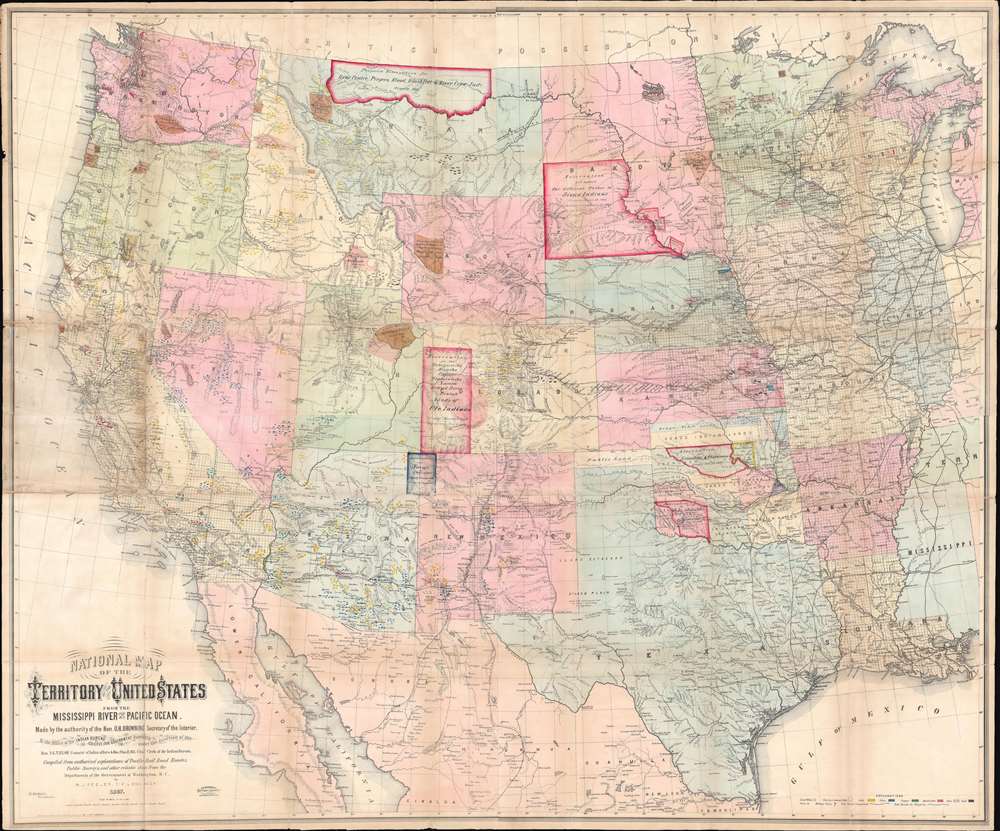
An extraordinary first-edition first-state example of William J. Keeler’s 1867 map of the Trans-Mississippi West - considered the finest post-Civil War railroad era map of the west - with unique manuscript annotations and additions relating to the American Indian Reservation System. This one of a kind historic document was likely the official example retained by the Indian Bureau, and possibly by Keeler himself, to administer and document the development of the American Indian Reservation system through the late 1860s.
The present example is the first edition of Keeler’s map, an enormous production of nearly 20 square feet. Most examples of the first edition were produced for presentation to government officials and other influentials. Seeking to further monetize the map, Keeler re-issued it in 1868 in two smaller editions, with coverage extended somewhat further to the east but with significant detail omitted, including the rectilinear surveys of the General Land Office.
What has been missed previously is that there are at least three variant states of the first edition, each readily differentiated by the progressive addition Indian reservations. We have not studied this issue exhaustively, and there may well be additional variant states, and many other differences, but the three we have noted can be identified as follows:
The lettering is consistent and practiced, almost certainly completed by the same masterful hand. The color schemes vary - the largest added reservations are outlined in pink, one is outlined in blue, while others feature brown wash or a combination of brown and pink wash. We have been unable to interpret the color coding: It may be that the colors reflect the different phases on which the reservations were added, their legal or administrative status, or idiosyncratic preferences. What is clear is that the annotations were added over time rather than all at once, as new treaties were signed, and new reservations compounded into the system. Such ongoing revision strongly points to the map being an administrative tool employed by someone working in the Indian Bureau - possibly Keeler himself.
Some, not all, of the manuscript additions to the present map were consigned to print on the later states of the first edition. For example, the Sisseton and Warpeton Sioux Reservation in eastern Dakota, the Uintah Valley Reserve in northeast Utah, and the Nez Perce Reservation in northern Idaho. Others appear on later states, but with minor adjustments: the aforementioned reservation in Colorado for the 'Tabequache Muache Capote Weeminuche Yampa Grand River Wintah Bands of Ute' is rendered simply as 'Tabequache Utes Indian Res' and lacks the vast boundaries provided on our copy. On the other hand, some of the additions don’t show up on any subsequent printed versions of the map, even though the reservations they denote were in fact established. In this category, among others, are the massive Sioux Reservation in southwestern Dakota (outlined in pink) and the Navajo Reservation straddling the New Mexico-Arizona border (outlined in blue).
Many of these inconsistencies likely represent the frantic efforts of the mapmaker, and the Indian Bureau in general, to keep up with what must have been a highly fluid and even chaotic situation in the early years of the Reservation system.
In all, this is an extraordinary copy of a most important map, well worthy of further research, and potential cornerstone piece for any collection focusing on the American West, the Indian Wars, or the development of the Reservation system. This map is owned jointly by Geographicus and Boston Rare Maps.
A Monumental Map inl Size and Importance
Keeler’s map has been praised as the 'the largest, finest and most detailed map of the West as it was then known.' (Anderson Galleries) A civil engineer, Keeler compiled the map while working at the Department of the Interior under 'the authority of the Hon. O.H.Browning Secretary of the Interior. In the Office of the Indian Bureau Chiefly for Government Purposes.' Taking advantage of the Department’s cartographic holdings of unique survey work and unpublished railroad surveys, he was able to achieve there-to-fore unprecedented detail and accuracy. Despite the circumstances of its production, the publication itself was a private venture, financed by Keeler himself, with the intention to capitalize on renewed enthusiasm for western expansion after the end of the Civil War.In Keeler's Own Words
The map depicts the country from just east of the Mississippi westward to the Pacific and from the Canadian border to the southern Texas. An 1867 newspaper promotional for the map, likely penned by Keeler, summarizes well its extraordinarily rich content, while pointing to its odd public-private character.This map was made by the authority of Hon. O. H. Browning, Secretary of the Interior, chiefly for government purposes…. It is a complete railroad map, the only one published which shows the whole of the great Pacific railroad routes, and their projections and branches, together with all other railroads in the States and Territories bordering on the Mississippi on both sides; showing at a glance the eastern connections of those Pacific roads with the existing railroad systems of the country. It shows the township and range lines of all public land surveys up to date; all Indian reservations, military posts, forts, and c. One important feature is the location of all the mineral lands in the States and Territories being given. In fact, it is just what every trade, traveler and business man of the West needs, and will prove invaluable to them. (Daily Kansas Tribune, Sept. 22 1867, p. 3)Certainly he was correct as no finer map of the American west then existed - the perfect tool for a government seeking to end the violent Indian Wars and administer a tentative if one-sided peace.
Publication History
To truly understand this map and the manuscript annotations that will be discussed later, it is important to first understand its publication history. Despite the map's astounding importance, it has received very little scholarship - likely due to lack of ancillary data and the elusiveness of Keeler himself.The present example is the first edition of Keeler’s map, an enormous production of nearly 20 square feet. Most examples of the first edition were produced for presentation to government officials and other influentials. Seeking to further monetize the map, Keeler re-issued it in 1868 in two smaller editions, with coverage extended somewhat further to the east but with significant detail omitted, including the rectilinear surveys of the General Land Office.
What has been missed previously is that there are at least three variant states of the first edition, each readily differentiated by the progressive addition Indian reservations. We have not studied this issue exhaustively, and there may well be additional variant states, and many other differences, but the three we have noted can be identified as follows:
- 1st state: No Tabequache Utes Reservation in western Colorado
- 2nd state: Tabequache Utes Reservation added, but no Colorado River Reservation in western Arizona
- 3rd state: Colorado River Reservation added
The Manuscript Annotation of the Reservation System
By far the map's most striking features are the boldly illustrated manuscript annotations appearing throughout. The annotations consist of wash and outline coloring to indicate reservation boundaries, with careful lettering identifying the reservation and often the dates of the relevant treaty and/or 'proclamation' of the reservation. For example, much of western Colorado is outlined in pink and labeledReservation for the Tabequache Muache Capote Weeminuche Yampa Grand River Wintah Bands of Ute Indians / Treaty – March 2, 1868. / Proclaimed Nov. 5, 1868.Two of the annotations indicate, not reservations, but the 1866 Chickasaw and Choctaw Cession of land between the Red and Canadian Rivers in modern-day Oklahoma. The earliest date given in the annotations is April 28, 1866 (the Chickasaw and Choctaw Cession), and the latest is February 24, 1869 (the Sioux Reservation in Dakota).
The lettering is consistent and practiced, almost certainly completed by the same masterful hand. The color schemes vary - the largest added reservations are outlined in pink, one is outlined in blue, while others feature brown wash or a combination of brown and pink wash. We have been unable to interpret the color coding: It may be that the colors reflect the different phases on which the reservations were added, their legal or administrative status, or idiosyncratic preferences. What is clear is that the annotations were added over time rather than all at once, as new treaties were signed, and new reservations compounded into the system. Such ongoing revision strongly points to the map being an administrative tool employed by someone working in the Indian Bureau - possibly Keeler himself.
Some, not all, of the manuscript additions to the present map were consigned to print on the later states of the first edition. For example, the Sisseton and Warpeton Sioux Reservation in eastern Dakota, the Uintah Valley Reserve in northeast Utah, and the Nez Perce Reservation in northern Idaho. Others appear on later states, but with minor adjustments: the aforementioned reservation in Colorado for the 'Tabequache Muache Capote Weeminuche Yampa Grand River Wintah Bands of Ute' is rendered simply as 'Tabequache Utes Indian Res' and lacks the vast boundaries provided on our copy. On the other hand, some of the additions don’t show up on any subsequent printed versions of the map, even though the reservations they denote were in fact established. In this category, among others, are the massive Sioux Reservation in southwestern Dakota (outlined in pink) and the Navajo Reservation straddling the New Mexico-Arizona border (outlined in blue).
Many of these inconsistencies likely represent the frantic efforts of the mapmaker, and the Indian Bureau in general, to keep up with what must have been a highly fluid and even chaotic situation in the early years of the Reservation system.
In all, this is an extraordinary copy of a most important map, well worthy of further research, and potential cornerstone piece for any collection focusing on the American West, the Indian Wars, or the development of the Reservation system. This map is owned jointly by Geographicus and Boston Rare Maps.
Cartographer
William J. Keeler (fl. c. 1856 - 1868) was an American civil engineer active during the second half of the 19th century. He is an elusive figure, and little is known of his birth and death dates, places, or early education. He appears in 1856, already working as a civil Engineer in Buffalo with the Erie Canal. In 1862 he received a civilian appointment, and possibly a honorary military rank, to work as an engineer at the Washington Naval Yard. He may also have worked at the Naval Yard in New York (Brooklyn). He was decommissioned in 1864 or 1865, after which he traveled west where he is recorded as an engineer with the Leavenworth, Lawrence and for Gibson Railroad Company. In 1865 he is also mentioned as working with the Union Pacific. In 1866 he was the chief engineer of the Kansas and Nesho Valley Railroad. He appears to have been employed with the department of the Interior Indian Bureau in by 1866 and/or 1867. He released his National Map of The Territory of The United States from the Mississippi River to the Pacific Ocean, one of the most important maps of the American west to appear in the 19th century, 1867. Although based upon government and railroad surveys, the map was a private publication and went through several subsequent editions, reissues, reformatting, and republications. Following the publication of the 2nd edition in 1868, Keeler seems to disappear from all record. More by this mapmaker...
Condition
Good. Original linen backing with some reinforcement. Some wear along original fold lines and minor loss at fold intersections.
References
OCLC 225197861. Rumsey 4640.001. Wheat, C. I., Mapping of the Transmississippi West, 1540 – 1861, 1170. A catalogue of The Everett D. Graff collection of Western Americana., 2281. Howes, W., U.S.iana (1650-1950): A Selective Bibliography in which are Described 11,620 Uncommon and Siginficant Books Relating to the Continental Portion of the United States, K22. The celebrated collection of Americana formed by the late Thomas Winthrop Streeter, 3077. Schulten, Susan, Mapping the Nation, p. 164. Martin, J., and Martin, R., Maps of Texas and the Southwest, 1513-1900, 47.