This item has been sold, but you can get on the Waitlist to be notified if another example becomes available.
1795 Laurie and Whittle Edition of Robert Sayer's West India Pilot
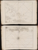
WestIndiaPilot-sayer-1795$17,500.00


Title
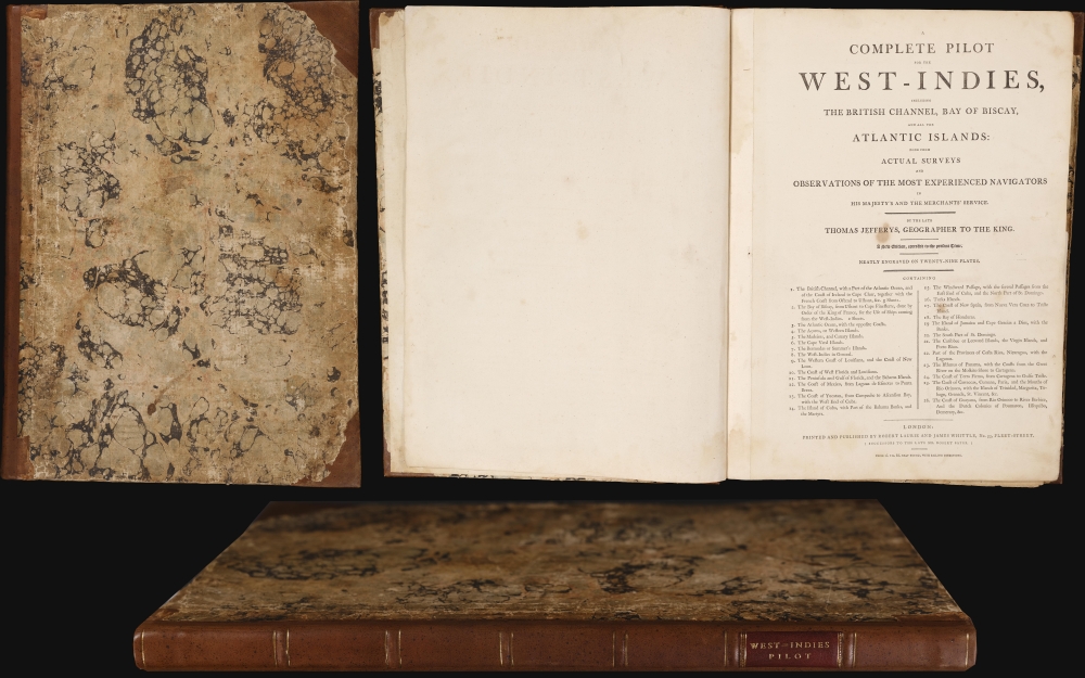
A Complete Pilot for the West-Indies, including the British Channel, Bay of Biscay, and all the Atlantic Islands: done from Actual Surveys.
1795 (dated) 21.5 x 16 in (54.61 x 40.64 cm) 1 : 1560000
1795 (dated) 21.5 x 16 in (54.61 x 40.64 cm) 1 : 1560000
Description
This is Robert Sayer's nautical atlas of the West Indies, A Complete Pilot for the West Indies, in its 1795 Laurie and Whittle edition. The Pilot showcases Thomas Jefferys' state-of-the-art British chartmaking during the American Revolutionary War (1775 - 1783). The present edition reflects Sayer's revisions following the Revolution, presenting the West Indies and the surrounding region as the changing political climate impacted the British sugar trade and its part in the infamous Triangle Trade, the systematic shipment of enslaved Africans to the West Indies and North America to facilitate the cultivation and processing of sugar.
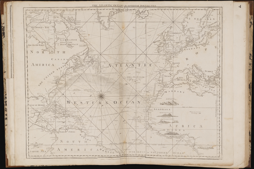
A third chart, of the Atlantic Ocean, appeared in earlier editions of the Pilot, but the example present here is a new plate, revised with information credited to the cartographer and colonial governor Thomas Pownall. This chart contains an array of sailing routes between Britain and the Americas, and includes a dramatic illustration of the Gulf Stream Current (Pownall's research on this phenomenon, and its impacts on navigation, incorporated and acknowledged the work of Benjamin Franklin). With its presentation not only of the American and European coast, but also that of West Africa and the Guinea Coast, this chart is evocative of the infamous Triangle Trade. The sailing routes presented focus on the Americas, but the coastal profiles all pertain to the African coast.
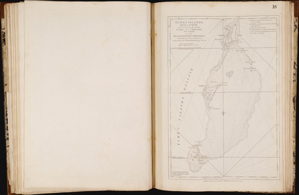
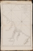
Of the maps pertinent to specific Caribbean islands that appeared in the Atlas, the only survivor is the chart of the Turks Islands. This important chart is the earliest obtainable large-scale chart of the Turks. It shows not only Grand Turk, Salt Key, and Sand Key, but also the shallows linking these islands. With copious depth soundings, anchorages, and emphasis on navigational hazards, its 'chartness' may be the reason to its retention in the Pilot. The Turks were an important source of salt from sea brine, essential to the trans-Atlantic voyage. Accordingly, the only settlements noted on the map are 'Salt rakers' huts.' During the American Revolution, the Continental Army depended on the Turks for salt for food preservation, and American fishing vessels used Turks salt to preserve their catches. Jefferys credited the cartographer to a 1753 survey attributed to the French schooners l'Aigle and l'Emeraude, further amended in 1770 by the British sloop Sir Edward Hawke.
Another note invokes an old, tantalizing goal:
Shortly after the publication of the Atlas, Sayer began to experiment with a more chart-focused work accompanied by a set of sailing instructions for navigating the West Indies. In 1778, he published several iterations of a variously-titled Neptune Occidental. This work first appeared with a scant 13 charts, most drawn from the 1775 West India Atlas, but surprisingly only one was derived from the excellent large-scale charts of that work - that of the Windward Islands. This version of the Neptune may have been a composite intended to test public interest, apparently with some success. Sayer and Bennett immediately revised and expanded it. As early as 1778, they published the Neptune Occidental. A Compleat Pilot for the West-Indies, including the British Channel, Bay of Biscay, and all the Atlantic islands, containing 25 charts. This work improved on the early versions in almost every aspect, including the incorporation of the 16 Jeffreys charts at the core of the West India Atlas. Most surviving examples of the Neptune Occidental were printed in 1782.
Following the American Revolution, Sayer began to update the Pilot, with some plates receiving minor updates but many being replaced, publishing it in 1792 under his own imprint. After his 1794 death, the Pilot was reprinted by Laurie and Whittle, who continued to update and add to the work as late as 1801.
An Overview
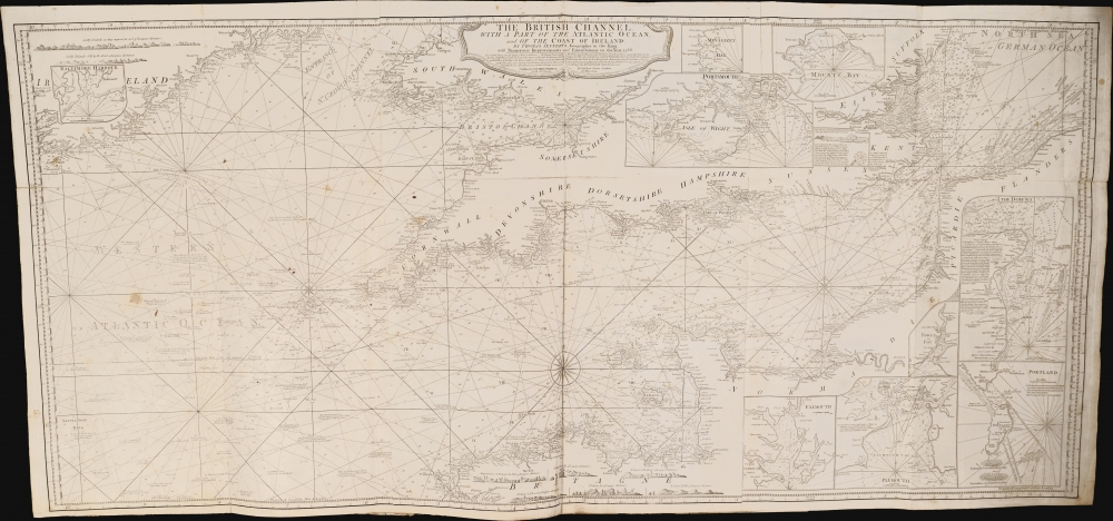
The Pilot's charts focus on the Caribbean Islands and their neighboring coasts, but as a British work, it also contains charts for the home ports of the British navigator and the nearby coastlines of the Continent. The earliest editions of the Pilot contained only single-sheet charts for the British Channel and the Bay of Biscay, but Sayers' final versions of the work, as here, contained an expansive three-sheet chart of the Channel and a two-sheet chart of the Bay of Biscay. The former, in particular, benefited from significant revisions as late as 1788.A third chart, of the Atlantic Ocean, appeared in earlier editions of the Pilot, but the example present here is a new plate, revised with information credited to the cartographer and colonial governor Thomas Pownall. This chart contains an array of sailing routes between Britain and the Americas, and includes a dramatic illustration of the Gulf Stream Current (Pownall's research on this phenomenon, and its impacts on navigation, incorporated and acknowledged the work of Benjamin Franklin). With its presentation not only of the American and European coast, but also that of West Africa and the Guinea Coast, this chart is evocative of the infamous Triangle Trade. The sailing routes presented focus on the Americas, but the coastal profiles all pertain to the African coast.
An Important Bermuda
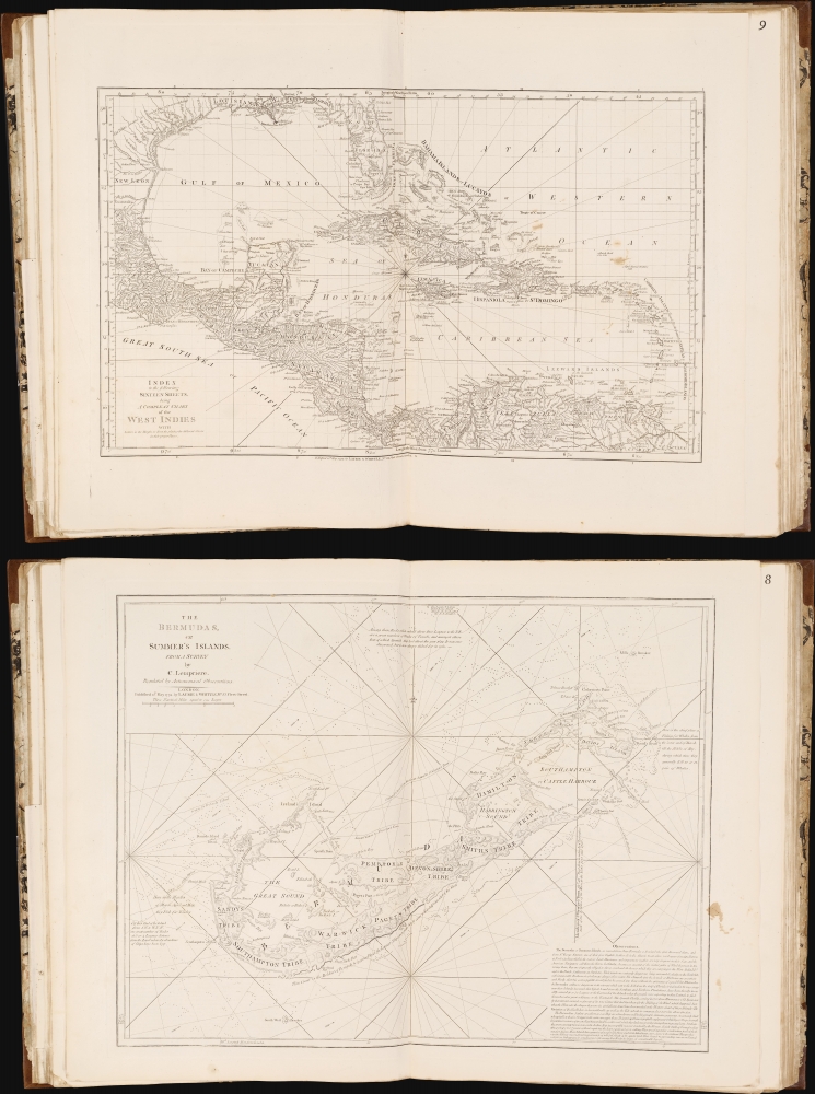
The journey across the Atlantic was seldom achieved nonstop; with this in mind, the Pilot included several charts of the islands to be found en route: the Canary Islands, the Azores, the Cape Verde Islands, and Bermuda. This last is particularly significant, being an iteration of the first commercial sea chart of Bermuda to incorporate data from Clement Lemprière's important 1738 map, A Complete Pilot for the West Indies - the first significant improvement on Bermudan geography since the 17th century. Sayer's version of the map was first engraved in 1775 for the West India Atlas, but it remained the premier Bermuda chart well into the 19th century.Heart of the 'Pilot'
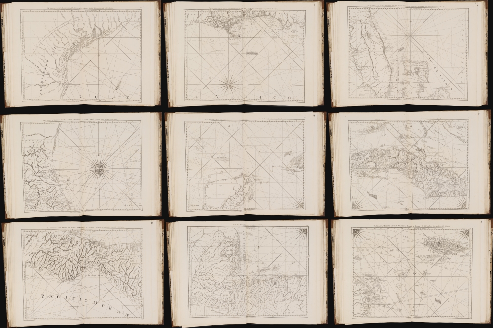
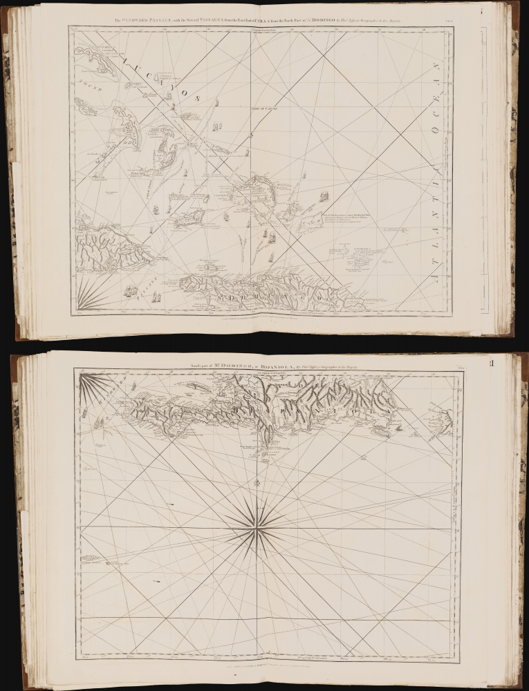
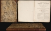
In compiling the Pilot, Sayer adapted the 17 charts at the heart of the earlier West India Atlas. These now formed the core of the Complete Pilot for the West Indies: 16 particular charts of the Gulf Coast, the West Indies, Central America, and Terra Firma, and a contextualizing key-map. All of the particular charts show evidence of at least minor changes over those from 1775 Atlas, and many are completely re-engraved with significant alterations to the coastlines and typographical corrections. Areas most updated include the Gulf Coast from the Mississippi to the Bay of Apalache; the Florida coastline, Cuba, and South America.Of the maps pertinent to specific Caribbean islands that appeared in the Atlas, the only survivor is the chart of the Turks Islands. This important chart is the earliest obtainable large-scale chart of the Turks. It shows not only Grand Turk, Salt Key, and Sand Key, but also the shallows linking these islands. With copious depth soundings, anchorages, and emphasis on navigational hazards, its 'chartness' may be the reason to its retention in the Pilot. The Turks were an important source of salt from sea brine, essential to the trans-Atlantic voyage. Accordingly, the only settlements noted on the map are 'Salt rakers' huts.' During the American Revolution, the Continental Army depended on the Turks for salt for food preservation, and American fishing vessels used Turks salt to preserve their catches. Jefferys credited the cartographer to a 1753 survey attributed to the French schooners l'Aigle and l'Emeraude, further amended in 1770 by the British sloop Sir Edward Hawke.
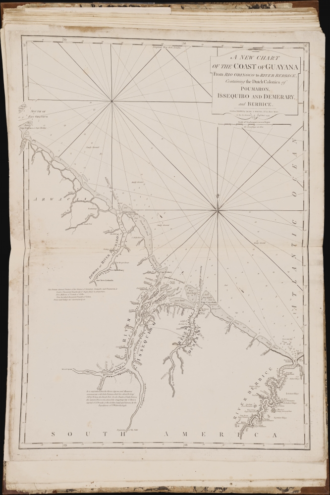
British Incursions against the Dutch in South America - and a hint of El Dorado?
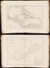
The last chart appearing in the Pilot, A New Chart of the Coast of Guyana from Rio Orinoco to River Berbice, made its first appearance in 1787. The present example is dated November 19, 1795. Both this and its precursors were among the newest charts in the Pilot. Even so, the 1795 version is significantly updated over the 1787. The whole coastline is completely revised, and there are corrections to river systems and settlements. In addition to its soundings, course headings, anchorages, and other purely nautical features, this chart details land features to an extent seen nowhere else in the Pilot. Buildings, forts, Indian villages, and plantations for sugar and cocoa are marked. A note tallies the rich production of sugar, rum, coffee, and cotton, while hinting at further wealth of cocoa and indigo. The region depicted here had thus become a prize, wrestled over by the Dutch and the English. During the Fourth Anglo-Dutch War (1780 - 1784), British privateers briefly captured settlements on the shores of the Rivers Essequibo and Demerara. Afterward, an increasing number of British colonists settled the region. By 1796, there was a permanent British presence, and by 1800, there were between 350 and 400 sugar plantations. Neither Sayer nor Laurie and Whittle provided a source for this chart, but it is an important addition to the Pilot as work of immediate colonial interest, produced in the wake of the painful British losses in the Americas following the Revolution.Another note invokes an old, tantalizing goal:
It is conjectured that the rivers Cajona and Mazaroni communicate with Lake Parima, which lies about 80 Leag. S.W. by W. from the Dutch Fort. On the Banks of Lake Parima the antient Discoverers placed the imaginary City of Manoa Capital of el Dorado, or the Golden Land, and famous by the Expeditions of Sr. Walter Raleigh.
Production of the West India Pilot
The present work appears to have been conceived as a digest, with a specifically nautical focus, of Robert Sayer's 1775 West India Atlas. This comprehensive volume was the work of Thomas Jefferys, who spent the last decade of his life assembling it. Following Jefferys' 1771 death, Sayer and his partner, John Bennett, completed the book. With its 39 plates of maps and charts, the West India Atlas was the first comprehensive English atlas of the Florida, the Gulf Coast, and the Caribbean. By 1794, it had been expanded to 61 plates, but throughout its run, at the heart were 16 charts of the West Indies and an accompanying key-map.Shortly after the publication of the Atlas, Sayer began to experiment with a more chart-focused work accompanied by a set of sailing instructions for navigating the West Indies. In 1778, he published several iterations of a variously-titled Neptune Occidental. This work first appeared with a scant 13 charts, most drawn from the 1775 West India Atlas, but surprisingly only one was derived from the excellent large-scale charts of that work - that of the Windward Islands. This version of the Neptune may have been a composite intended to test public interest, apparently with some success. Sayer and Bennett immediately revised and expanded it. As early as 1778, they published the Neptune Occidental. A Compleat Pilot for the West-Indies, including the British Channel, Bay of Biscay, and all the Atlantic islands, containing 25 charts. This work improved on the early versions in almost every aspect, including the incorporation of the 16 Jeffreys charts at the core of the West India Atlas. Most surviving examples of the Neptune Occidental were printed in 1782.
Following the American Revolution, Sayer began to update the Pilot, with some plates receiving minor updates but many being replaced, publishing it in 1792 under his own imprint. After his 1794 death, the Pilot was reprinted by Laurie and Whittle, who continued to update and add to the work as late as 1801.
Publication History and Census
A Complete Pilot for the West Indies was published by Robert Sayer in 1792, and taken over by Laurie and Whittle in 1794, after his death. Their edition of 1795, with which this corresponds, appears in about 30 institutional collections, but it is extremely scarce on the market. We see no catalog listings or auction records for this edition. Of the 1792 Sayer edition, we are aware of only one example that has come to market.CartographerS
Thomas Jefferys (1695 - November 20, 1771) was one of the most prominent and prolific map publishers and engravers of his day. Jefferys was born in Birmingham and was apprenticed to the engraver Emmanuel Bowen in 1735. Later, in the 1740s he engraved several maps for the popular periodical Gentleman's Magazine. Around 1740 Jefferys was finally able to go into business for himself and in 1746 received an appointment as 'Geographer to Fredrick, Prince of Wales,' which shortly after translated to the position of 'Royal Cartographer to King George III.' Jefferys initially specialized in compiling and re-engraving the works of earlier cartographers into more coherent cartographic wholes. Later, while not salaried position, Jefferys' appointment as 'Royal Cartographer' guaranteed preferential access to the most up to date cartographic material available, allowing him to produce new and updated charts of exceptional accuracy. He his best known for his maps of the Americas, particularly the posthumously published 1775 American Atlas, which included some of the finest and most important late colonial era maps of America ever made. Despite his prolific publishing history, royal appointments, and international publishing fame, Jefferys lived most of his life in dire economic straits. He was bailed out of bankruptcy by Robert Sayer during the production of the American Atlas. In the end, Jefferys died suddenly with very little to his name. Nonetheless, his cartographic legacy survived, and even after his death in 1771, many of his important maps continued to be published and republished by Sayer and Bennet, Conrad Lotter, Georges Louis Le Rouge, Laurie and Whittle, and others. Many attribute some of Jefferys best maps to the colorful and criminally inclined Irish cartographic genius Braddock Mead (John Green, c. 1688 - 1757), who is considered the 'secret behind Jefferys.' Jefferys was succeeded by his son, also Thomas, who had little success as a cartographer and eventually partnered with, then sold his stock and plates to William Faden - Jefferys' true heir. More by this mapmaker...
Robert Sayer (1725 - January 29, 1794) was an important English map publisher and engraver active from the mid to late 18th century. Sayer was born in Sunderland, England, in 1725. He may have clerked as a young man with the Bank of England, but this is unclear. His brother, James Sayer, married Mary Overton, daughter-in-law of John Overton and widow of Philip Overton. Sayer initially worked under Mary Overton, but by December of 1748 was managing the Overton enterprise and gradually took it over, transitioning the plates to his own name. When Thomas Jefferys went bankrupt in 1766, Sayer offered financial assistance to help him stay in business and, in this way, acquired rights to many of the important Jefferys map plates as well as his unpublished research. From about 1774, he began publishing with his apprentice, John Bennett (fl. 1770 - 1784), as Sayer and Bennett, but the partnership was not formalized until 1777. Bennett retired in 1784 following a mental collapse and the imprint reverted to Robert Sayer. From 1790, Sayer added Robert Laurie and James Whittle to his enterprise, renaming the firm Robert Sayer and Company. Ultimately, Laurie and Whittle partnered to take over his firm. Sayer retired to Bath, where, after a long illness, he died. During most of his career, Sayer was based at 53 Fleet Street, London. His work is particularly significant for its publication of many British maps relating to the American Revolutionary War. Unlike many map makers of his generation, Sayer was a good businessman and left a personal fortune and great estate to his son, James Sayer, who never worked in the publishing business. Learn More...
Laurie and Whittle (fl. 1794 - 1858) were London, England, based map and atlas publishers active in the late 18th and early 19th century. Generally considered to be the successors to the Robert Sayer firm, Laurie and Whittle was founded by Robert Laurie (c. 1755 - 1836) and James Whittle (1757-1818). Robert Laurie was a skilled mezzotint engraver and is known to have worked with Robert Sayer on numerous projects. James Whittle was a well-known London socialite and print seller whose Fleet Street shop was a popular haunt for intellectual luminaries. The partnership began taking over the general management of Sayer's firm around 1787; however, they did not alter the Sayer imprint until after Sayer's death in 1794. Apparently Laurie did most of the work in managing the firm and hence his name appeared first in the "Laurie and Whittle" imprint. Together Laurie and Whittle published numerous maps and atlases, often bringing in other important cartographers of the day, including Kitchin, Faden, Jefferys and others to update and modify their existing Sayer plates. Robert Laurie retired in 1812, leaving the day to day management of the firm to his son, Richard Holmes Laurie (1777 - 1858). Under R. H. Laurie and James Whittle, the firm renamed itself "Whittle and Laurie". Whittle himself died six years later in 1818, and thereafter the firm continued under the imprint of "R. H. Laurie". After R. H. Laurie's death the publishing house and its printing stock came under control of Alexander George Findlay, who had long been associated with Laurie and Whittle. Since, Laurie and Whittle has passed through numerous permeations, with part of the firm still extant as an English publisher of maritime or nautical charts, 'Imray, Laurie, Norie and Wilson Ltd.' The firm remains the oldest surviving chart publisher in Europe. Learn More...
Condition
Very good. Folio bound in marble paper over boards; re-backed and re-cornered in calf, gold tooled with red morocco label. Title page, 26 charts (one comprised of three plates, another of two); faint staining and moderate foxing on few charts; some bottom centerfold wear; sheets 1 and 2 with slight separation at juncture of folds; plate 6 trimmed at top with slight loss of border; plate 26 with marginal mends and some reinstatement of border.
References
OCLC 1399205476. Not in Rumsey. Not in Phillips.