This item has been sold, but you can get on the Waitlist to be notified if another example becomes available, or purchase a digital scan.
1831 Dower / Teesdale Map of the Caribbean, West Indies
WestIndies-dower-1831$150.00

Title
West Indies.
1831 (dated) 12.5 x 16 in (31.75 x 40.64 cm) 1 : 6500000
1831 (dated) 12.5 x 16 in (31.75 x 40.64 cm) 1 : 6500000
Description
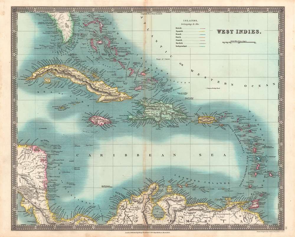
This is an especially vivid example of John Dower and Henry Teesdale's 1831 map of the West Indies published in their A New General Atlas of the World. This map was published when the region was undergoing rapid transformations resulting from the end of the slave trade and the institution of slavery itself.
The abolition of slavery did not end unfree labor, as the process was often gradual and colonial governments were more concerned with compensating plantation owners that ensuring the livelihood of newly emancipated people. For instance, in Jamaica, emancipated slaves were initially forced to 'apprentice' for their former owners for several years. Inequality was extreme and former slaveowners sought creative methods to reinstitute slavery in all but name, even though the plantation economy was clearly becoming unviable for reasons besides emancipation. Continuing racial tensions and heavy-handed administration by the white elite led to violence, as with the Morant Bay rebellion in 1865.
A Closer Look
This map spans the Caribbean, including elements of Florida, Central America, and northern South America, and taking in the Bahamas, Lesser Antilles (or Windward and Leeward Islands, or the Caribbee Islands), Cuba, Hispaniola, Puerto Rico, Jamaica, and other islands. Territories are 'color coded' to associate them with the colonial empires that controlled them at the time, after some rearrangement following the Napoleonic Wars. Latitude and longitude are noted in the ornately detailed margins.The Decline of Plantation Slavery
Although European outposts on Caribbean islands had strategic military value, they primarily were used for the planting of cash crops (sugar above all) by enslaved African or African-descended laborers. Along with economic factors, the growing Transatlantic abolitionist movement and the Age of Revolutions, particularly the Haitian Revolution, signaled that the days of slave trading were numbered in the late 18th century. Between 1780 and 1820, most European empires and the United States banned the slave trade, though the abolition of slavery itself usually lagged by a generation or two. This lag period was especially fraught, as the established economic order had a clear interest in maintaining slavery, while enslaved people and free people of color pressed for more immediate abolition. Slave uprisings, particularly the Haitian Revolution, terrified plantation owners, who invested heavily in 'security' and often became more stubborn in their commitment to plantation slavery as a result, further heightening tensions. A series of slave revolts occurred in the West Indies in the 1820s-1830s, including Bussa's Rebellion on Barbados (1816), the Baptist War on Jamaica (1831 – 1832), and Nat Turner's Rebellion (1831), that hastened the abolition of slavery in several European colonial empires. Of the empires shown here, the British abolished slavery in 1833, the Spanish colonies largely abolished slavery upon independence, while slavery remained practiced on Puerto Rico and Cuba until the 1870s – 1880s, the French abolished slavery in their empire (for the third time) in 1848, the Dutch in 1860 – 1863, the Danish in 1848, and the Swedish, with a single colony at Saint Barthélemy (here as St. Bartholomew), in the mid-1840s.The abolition of slavery did not end unfree labor, as the process was often gradual and colonial governments were more concerned with compensating plantation owners that ensuring the livelihood of newly emancipated people. For instance, in Jamaica, emancipated slaves were initially forced to 'apprentice' for their former owners for several years. Inequality was extreme and former slaveowners sought creative methods to reinstitute slavery in all but name, even though the plantation economy was clearly becoming unviable for reasons besides emancipation. Continuing racial tensions and heavy-handed administration by the white elite led to violence, as with the Morant Bay rebellion in 1865.
Publication History and Census
This map was engraved by John Dower for the 1831 edition of A New General Atlas of the World, published by Henry Teesdale. This appears to be an especially rare presentation of this map, as most examples from this or other editions of A New General Atlas do not show such vivid and full color, only hand-colored outlines of territories. The 1831 edition of this map is only independently cataloged in the holdings of six institutions, while the entire atlas is held by roughly a dozen institutions, though as stated above the present map may be distinct from those examples in coloration.CartographerS
John James Dower (June 1, 1825 - 1901) was a well-respected mapmaker, print seller, and publisher based in London, England. Dower is the heir to the more prominent London engraver and mapmaker John Crane Dower (1791 - 1847). Dower worked with many prominent middle to late 19th century London map publishers including Weller, Cassell, Bacon, Petermann, and others. He was elected to the Royal Geographical Society in 1854. Dower also published on maps his own account including one atlas and various school geographies. In addition to his cartographic work, Dower is well known as an engraver of military scenes. More by this mapmaker...
Henry Teesdale (December 1776 - January 1856) was a British map publisher active in the first half of the 19th century. Teesdale was born in London. He was elected to the Royal Geographical Society in 1830. Teesdale initially partnered with John Hordan and William Colling Hobson as Henry Teesdale and Company, but this partnership was dissolved in 1832. Afterwards Teesdale continued to publish maps and atlases on his own account. He worked with several major British map engravers of the period including John Crane Dower, Christopher Greenwood, and Josiah Henshall, among others. His most prominent work is a large map of the world engraved by Dower. He must have enjoyed considerable commercial success because in 1845 he is registered as a partner in the Royal Bank of Scotland. Teesdale died in January of 1856 and was buried in All Souls, Kensal Green. Learn More...
Source
Dower, John, A New General Atlas of the World, (London: Teesdale) 1831.
Condition
Good. Strip of discoloration just to the left of the centerfold. Minor toning.
References
OCLC 43221367.