This item has been sold, but you can get on the Waitlist to be notified if another example becomes available, or purchase a digital scan.
1796 Faden and Delarochette Map of the West Indies
WestIndies-faden-1796$500.00

Title
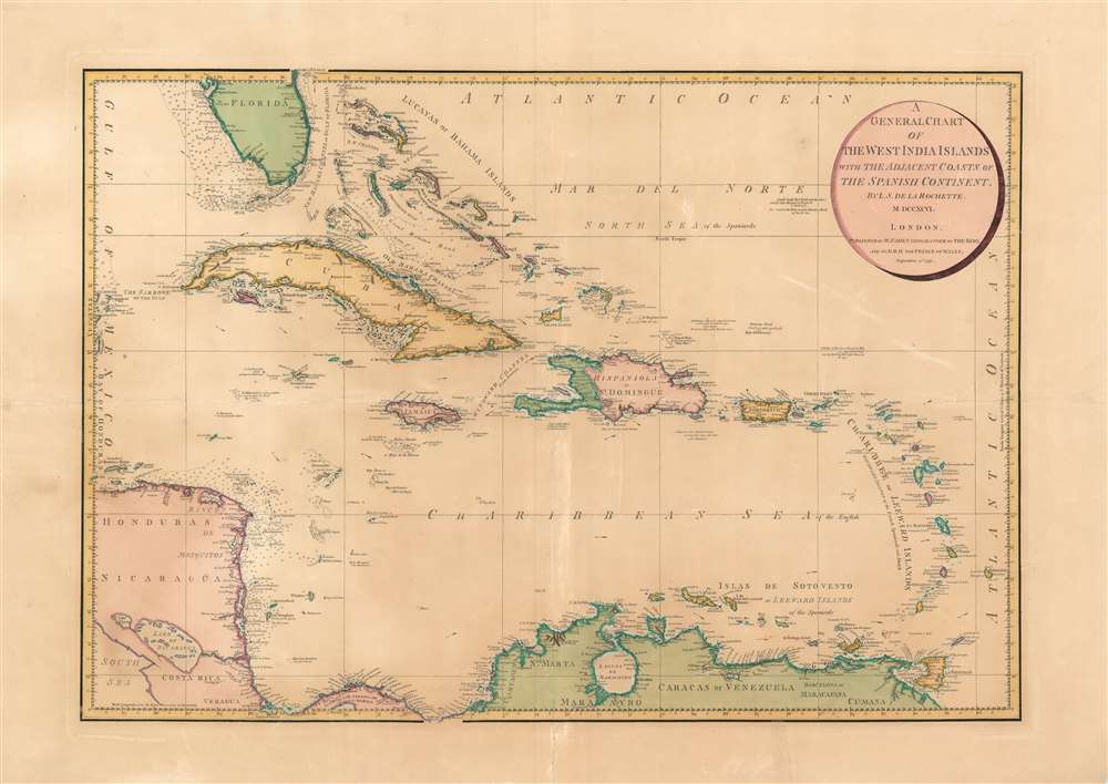
A General Chart of the West India Islands: With the Adjacent Coasts of the Spanish Continent.
1796 (dated) 20.5 x 29.5 in (52.07 x 74.93 cm) 1 : 4300000
1796 (dated) 20.5 x 29.5 in (52.07 x 74.93 cm) 1 : 4300000
Description
This elegant, large map is William Faden's 1796 map of the West Indies, drawn by the British mapmaker Louis Stanislaw de la Rochette (Delarochette.) Delarochette was the preeminent cartographer working for the prolific map publisher Faden at the end of the 18th century, and this map was among the finest available, and certainly the largest English folio map to focus specifically on the West India Islands during this period. Properly speaking it is a chart, with no detail inland but an abundant and precise treatment of the coastlines. Its scope extends from Rattan or Roatán island off the coast of Honduras in the west, to include Barbados in the east; the map encompasses Trinidad in the south and Tampa Bay in the north.
Referencing the Work of Others
Unlike many cartographers of the period, Delarochette takes pains to note his sources. Notations applied to the chart indicate Delarochette's studious comparison of current navigators' charts with older works, some by prominent mapmakers. For example, he notes that on the approach to Costa Rica, there can be found a 'Baho de la Madalena on some charts.' Between the Mosquito Coast and Grand Cayman are shallows and a possible island marked 'La Misteriosa according to Bellin seen by Capt. Jos. Maud May 21, 1757.' At the mouth of the Old Bahama Channel is marked 'Cayo Verde according to the Spaniards'. Due north of the Virgin Islands and due east of the Bahamas, a sandbank is described as 'seen by Capt. Mourand of Nantes 6 April 1773... this must be the Bela and the Staminco Bank of Van Keulen.' Throughout the map, not only the islands but the bodies of water themselves are noted as the possessions of European colonial powers: the Caribbean Sea is called the sea 'of the English;' The Windward Islands are 'of the French Spaniards and Dutch' and the Leeward Islands and the Mar del Norte - that is to say, the Atlantic - are named 'Spanish waters'. Florida and her waters, though the map denies it, were at the time Spanish territory.Publication History and Census
This map was separately issued and is scarce. It is cataloged only in two institutional collections, the British Library, and the University of Florida. Examples did occasionally appear in composite atlases, and an example appears in at least one example of Faden 1811 General Atlas (see Rumsey).CartographerS
William Faden (July 11, 1749 - March 21, 1836) was a Scottish cartographer and map publisher of the late 18th century. Faden was born in London. His father, William MacFaden, was a well-known London printer and publisher of The Literary Magazine. During the Jacobite Rebellion (1745 - 1746), MacFaden changed his family name to Faden, to avoid anti-Scottish sentiment. Faden apprenticed under the engraver James Wigley (1700 - 1782), attaining his freedom in 1771 - in the same year that Thomas Jefferys Sr. died. While Thomas Jefferys Sr. was an important and masterful mapmaker, he was a terrible businessman, and his son, Jefferys Jr., had little interest in building on his father's legacy. MacFaden, perhaps recognizing an opportunity, purchased his son a partnership in the Jefferys firm, which subsequently traded as 'Faden and Jefferys'. Jefferys Jr. also inherited Jefferys Sr.'s title, 'Geographer to the King and to the Prince of Wales'. With little interest in cartography or map publishing, Jefferys Jr. increasingly took a back seat to Faden, and by 1776, he had withdrawn from day-to-day management, although he retained his financial stake. The American Revolutionary War (1775 - 1783) proved to be a boom for the young 'Geographer to the King', who leveraged existing materials and unpublished manuscript maps to which he had access via his official appointment to publish a wealth of important maps, both for official use and the curious public - this period of prosperity laid the financial underpinning for Faden, who by 1783, at the end of the war, acquired full ownership of the firm and removed the Jefferys imprint. In 1801, he engraved and published the first maps for the British Ordnance Survey. By 1822, Faden published over 350 maps, atlases, and military plans. He retired in 1823, selling his plates to James Wyld Sr. Faden died in 1836. More by this mapmaker...
Louis Stanislaw d'Arcy Delarochette (1731 - 1802) was a British cartographer and engraver active in London, England in the late 18th century. Delarochette produced numerous maps in conjunction with various other contemporary British cartographers including Faden, Jefferys, Laurie and Whittle, Arrowsmith, and Bowles. Delarochette is perhaps best known for his monumental eight sheet map of South America, which was used to settle numerous border disputes throughout the continent. He also produced an influential map of the Cape of Good Hope, a fine map of the West Indies, and worked with Sayer and Kitchin on their A new map of North America wherein the British Dominions in the continent of North America, and on the islands of the West Indies, are carefully laid down from all the surveys, hitherto made... Learn More...
Source
Faden, W. General Atlas London, 1801-11.
Condition
Very good condition. Even toning. Some areas of scuffing. Mended splits along folds with minimal impact on printed image.
References
OCLC 1062237495. Rumsey 2104.