1927 Hamburg-America Pictorial Map of the West Indies
Westindies-hamburgamerican-1927$750.00

Title
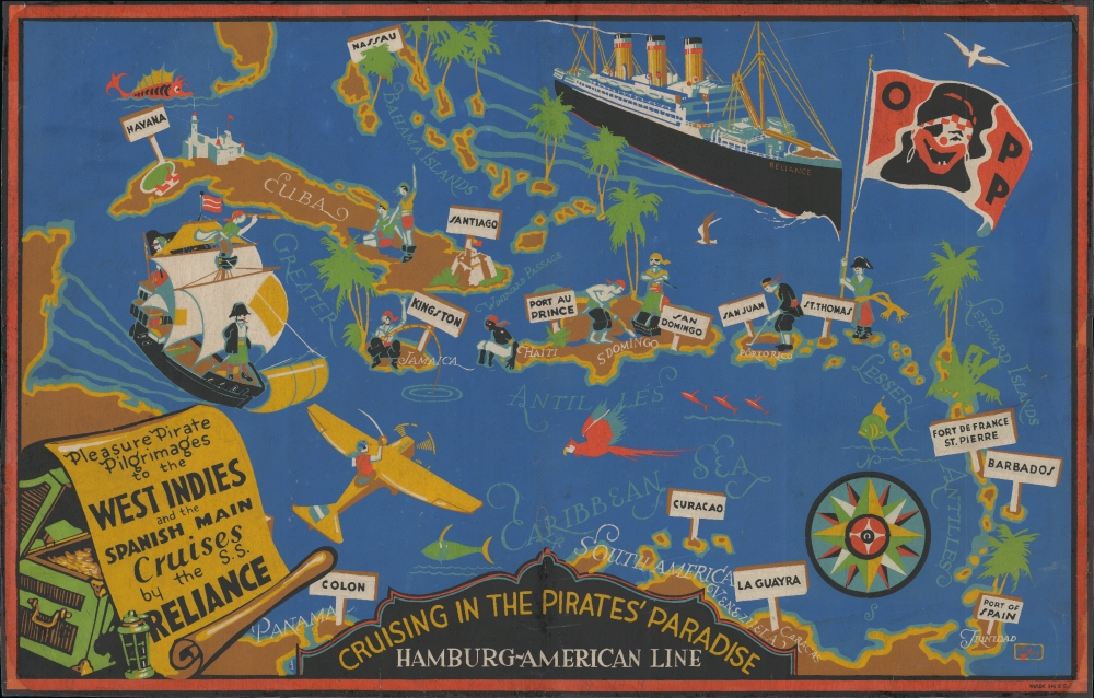
Cruising in the Pirates' Paradise Hamburg-American Line. / Pleasure Pirate Pilgrimages to the West Indies and the Spanish Main Cruises by the S.S. Reliance.
1927 (undated) 16.75 x 22.25 in (42.545 x 56.515 cm)
1927 (undated) 16.75 x 22.25 in (42.545 x 56.515 cm)
Description
This is a c. 1927 Hamburg-America pictorial map of the West Indies promoting 'Pleasure Pirate Pilgrimage' cruises. The map evokes the romanticization of the 'pirate' and exotification of the Caribbean, as well as the decadence of the Roaring '20s.
Pleasure Pirate?
As described by a c. 1927 magazine advertisement, the Hamburg-America S.S. Reliance offered pirate-themed cruise adventures throughout the West Indies and CaribbeanA special entertainment feature of these cruises is the activity of the renowned 'Order of Pleasure Pirates'. Headed by Kaptain Kidder and this Board of Buccaneers, the jollifications of the Order introduce, in a modern setting, the colorful atmosphere of the pirates of old and appeal to an inborn sense of romance and adventure that lurks in the heart of every traveler on pleasure bent.Pirate Pleasure Pilgrimages were introduced by Hamburg-America in 1926 and advertised until at least 1929 - likely the service lost popularity when the decadence of the Roarin' 20s was brought down by Black Thursday and the onset of the Great Depression.
Members of the order enjoy themselves clad in pirate costumes, in the picturesque Pirates' Den and elsewhere on board and their program of festivities includes initiation ceremonies, pirate meetings, treasure hunts, pirate balls and other interesting 'stunts'.
A Closer Look
The map focuses on the West Indies, covering from southern Florida to Trinidad, thus embracing the Bahamas, the Greater and Lesser Antilles, and parts of northern South America. Stylized 'pleasure pirates' play golf, bury treasure, frolic on beaches, fly airplanes, and fish. Major ports visited by the Reliance are highlighted with signs. The overall style gives the impression of screen printing, but we cannot say with certainty.Publication History and Census
This promotional map was printed in the United States. The only indication of the artist is a cryptic logo in the lower right. We have dated it based on contemporaneous advertisements for the 'Pleasure Pirate' cruises, which appear from 1926 - 1929. This is the only known example.Condition
Average. Backed on archival tissue. Some damage and infill at all corners and elsewhere on the border.
References
'Pirates of the Caribbean: Soft Exoticism and the Aesthetics of Diversity', in Essays: Exploring the Global Caribbean, ed. Roberson, S., (Cambridge Scholars).