This item has been sold, but you can get on the Waitlist to be notified if another example becomes available, or purchase a digital scan.
1745 Hermann Moll Map of the West Indies w/Galleon Routes
WestIndies-moll-1745$325.00

Title
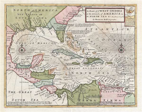
A Chart of ye West-Indies or the Islands of the Americas in the North Sea and c. Being ye Present Seat of War.
1745 (undated) 11 x 14 in (27.94 x 35.56 cm) 1 : 13500000
1745 (undated) 11 x 14 in (27.94 x 35.56 cm) 1 : 13500000
Description
Drawn at the tail end of the Golden Age of Caribbean Piracy, this is a stunning posthumous example of Herman Moll's important map of the West Indies, revised in 1745 to illustrate the War of Jenkins' Ear (Guerra del Asiento, 1739-1748)) and the Spanish Galleon Trade. Centered on Cuba, the map covers all of the west Indies from Mexico to the Windward Island and from North Carolina (Albemarle Sound) to the Spanish Main, including most of Central America, the Gulf Coast, the course of the Mississippi River as for north as Fort Prudhomme, and most of modern day Colombia and Venezuela.
Cartographically this map is based upon Moll's earlier maps issued with Thomas Bowles c. 1729. However, here it has been updated and revised to reflect events associated with the War of Jenkins' Ear. Fought between Britian and Spain, the oddly names War of Jenkins' Ear, was primarily motivated by powerful trading houses in England. After the War of Spanish Succession, the 1713 Treaty of Utrecht gave Britain a 30 year Asiento, or contract-right, to supply an unlimited number of slaves to the Spanish colonies. This provided immensely profitable to British slave traders, but was unpopular among the Spanish, who believed that the British were abusing the Asiento to smuggle other goods. Accordingly, in the 1729 Treaty of Seville, which ended the Anglo-Spanish War, Spain demanded the right to board British Asiento trading ships to inspect and potentially seized contraband.
According to the legend, in one such incident in 1731 the Spanish privateer Juan de León Fandiño, boarded the English ship, Rebecca, captained by Robert Jenkins. Fandiño accused Jenkins of smuggling and in an act of unnecessary cruelty sliced off Jenkins' left ear, telling him to say to the English king, 'Go, and tell your King that I will do the same, if he dares to do the same.' Jenkins, it is reported, presented his severed ear to Parliament. These, and other depredations, as well as pressure from the South Sea Company and other trading concerns, lead England to declare war on Spain in October of 1739. Although the War of Jenkins' Ear became subsumed in the great War of Austrian Succession, most of the major action in the West Indies had died down by 1742. Nonetheless, the war essentially gave free reign to Spanish and British privateers in the region to vigorously plunder one other.
Another way to understand this map as well as Moll's larger map of the same region is as a guide to English piracy and privateering in the West Indies. Moll, most likely through his coffeehouse acquaintance with pirates William Dampier and Woodes Rogers, offers a wealth of information on the traffic of silver bearing Spanish treasure fleets en route from the Mexican port of Veracruz, through the islands, to Spanish ports in Europe.
Following the dotted line, Moll identifies the Spanish treasure fleet's entrada into the Caribbean via the passage between Granada and Trinidad. The fleet then sailed westwards, skirting the Spanish Main until they reached Cartagena, where they rested and provisioned before heading northwards, rounding western Cuba and stopping in Havana. Using the strong Gulf Stream current - shown here - ships would sail northwards from Havana while being steadily forced to the southeast thus alighting at the deep-water port of Veracruz. On the return, laden with silver from the mines of San Luis Potosi, the Spanish fleet took advantage of eastward blowing trade winds, which helped to overcome the strong current on the sail to Havana. From Havana, they would travel northwards via the narrow passage between Florida and the Bahamas before cutting eastward and out to sea at St. Augustine. It was here, in this crucial passage between the English dominated Bahamas and Spanish Florida, that the most nefarious pirates lay in wait for their prey.
This map was issued in a number of different states from 1729 to about 1750. Most commonly it appeared as plate no. 55 in Herman Moll and Thomas Bowles' Atlas Minor. The present example was revived and revised for an updated edition of John Churchill's Collection of Voyages and Travels.
Cartographer
Herman Moll (1654 - 1732) was an important 18th century map publisher and engraver based in London and Holland. Moll's origins are disputed with some suggesting he was born in the Netherlands and others Germany - the Moll name was common in both countries during this period. Most likely Moll was a German from Bremen, as his will, friends, and contemporaries suggest. What is known for certain is that he moved to London in 1678, possibly fleeing the Scanian War, where he worked as an engraver for Moses Pitt and other London map publishers. Around the turn of the century, Moll set up his own shop where he produced a large corpus of work known for its high quality and decorative flair. As a new émigré to England, Moll made himself more English than the English, and through his cartography proved a fierce advocate for his adopted nation. Most of Moll's early maps were issued as loose sheets that would be bound to order, however, he did publish several important atlases late in his career. Moll is said to have made the bold claim that without a doubt "California is an Island" and that he "had in [his] office mariners who have sailed round it." While California may not be an island (yet), it is true that moll had talent for attracting interesting friends and acquaintances. He frequented London's first stock exchange, Jonathan's Coffeehouse at Number 20 Exchange Alley, Cornhill. At the time Jonathan's was known as "a place of very considerable concourse for Merchants, sea faring Men and other traders" (Erleigh, The Viscount, The South Sea Bubble, Manchester: Peter Davies, Ltd., 1933, 21). Eventually this activity attracted the interest of stock brokers, who inspired by sailor's tales, sponsored the ill-fated South Sea Company, the world's first stock bubble. Moll's close circle, mostly from the Coffee House, included scientist Robert Hooke, the writers Daniel Defoe (Robinson Crusoe) and Jonathan Swift (Gulliver's Travels), the pirates William Dampier, William Hacke and Woodes Rogers, and the archeologist William Stukeley. Herman Moll's work was highly regarded for its decorative beauty and was pirated, most notably by the Irish publisher George Grierson, both in his lifetime and after his 1732 death at St. Clement Danes, London. More by this mapmaker...
Source
Churchill, J., Collection of Voyages and Travels (London: Thomas Osborne) 1747.
Condition
Very good. Original pressmark visible. Blank on verso.
References
Phillips (America) p. 1054. OCLC 17589625.