This item has been sold, but you can get on the Waitlist to be notified if another example becomes available, or purchase a digital scan.
1790 Robert Sayer Nautical Map of the West Indies, Florida, Caribbean
WestIndies-sayer-1790$3,750.00


Title
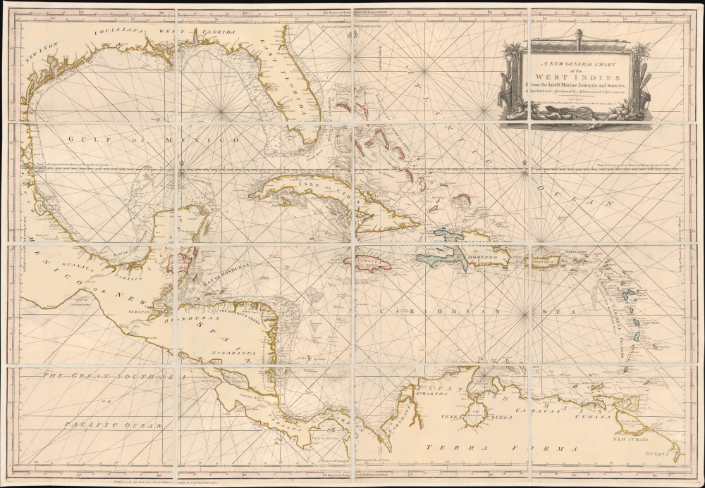
A New General Chart of the West Indies From the latest Marine Journals and Surveys, Regulated and Ascertained by Astronomical Observations.
1790 (dated) 29 x 41.75 in (73.66 x 106.045 cm) 1 : 4375000
1790 (dated) 29 x 41.75 in (73.66 x 106.045 cm) 1 : 4375000
Description
This is Robert Sayer's exceptional 1790 nautical map of the West Indies and Gulf of Mexico. This map emerged, much updated, on the cusp of significant regional upheaval, including conflicts related to the French Revolutionary Wars (1792 - 1802) and the Haitian Revolution (1791 - 1804), events that disrupted shipping, provoked privateering and blockades, and reshaped the patterns of trade.
A Closer Look
Coverage embraces the West Indies, Florida, and the Gulf of Mexico from Panuco to Barbados and from Mobile Bay to Panama. It includes the Gulf Littoral, Florida, all of Central America, the northern coast of South America, and the Greater and Lesser Antilles, including the Bahamas. It offers meticulous coastal detail with detailed soundings, but particularly around Florida, the Yucatan, the Bay of Honduras, the Mosquito, and Nicaragua. Belize, then an unofficial British colony, is identified as 'British Logwood Cutters' - see below.Belize: British Logwood Cutters
British logwood cutters, called 'Baymen', were English adventurers established in present-day Belize from the 17th century. They take their name from logwood (Haematoxylum campechianum), a tree prized for producing deep red, purple, and black dyes. Many were former pirates (and privateers) who turned to logwood after the suppression of piracy in the 1720s. Their settlements were informal and seasonal at first, but soon emerged as permanent camps defended against Spanish expulsion attempts. The cutters organized themselves in a rough system of self-governance, allocating cutting grounds and resolving disputes through local councils, laying the foundation for subsequent British colonial administration. Logwood exports to Europe, especially Britain, became highly lucrative, feeding demand from the textile industry, and despite repeated Spanish raids, the British government tolerated and eventually formalized the trade as part of its broader Caribbean interests. A series of treaties, including the Treaty of Paris (1763) and the Treaty of Versailles (1783), recognized British logging rights, though sovereignty was nominally claimed by Spain. The region became an official colony, British Honduras, in 1862. Over time, as logwood stands were depleted, the cutters shifted toward mahogany.Publication History and Census
This chart was first published by Sayer and Bennet in 1779. The present example, dated 1790, is the second edition. The map was subsequently acquired by Laurie and Whittle, who issued editions in 1794, 1799, and 1802. The map is also the source for the important Osgood Carlton / Norman chart of the same region, published in 1789 (Geographicus: WestIndies-norman-1789). This chart is a separate issue and notably distinct from the charts of the West Indies Sayer inherited from Thomas Jeffreys, published for the 1775 West India Atlas. We see a few examples of the 1779 edition in OCLC, but no holdings of the present 1790 edition. It is rare to the market in any edition.Cartographer
Robert Sayer (1725 - January 29, 1794) was an important English map publisher and engraver active from the mid to late 18th century. Sayer was born in Sunderland, England, in 1725. He may have clerked as a young man with the Bank of England, but this is unclear. His brother, James Sayer, married Mary Overton, daughter-in-law of John Overton and widow of Philip Overton. Sayer initially worked under Mary Overton, but by December of 1748 was managing the Overton enterprise and gradually took it over, transitioning the plates to his own name. When Thomas Jefferys went bankrupt in 1766, Sayer offered financial assistance to help him stay in business and, in this way, acquired rights to many of the important Jefferys map plates as well as his unpublished research. From about 1774, he began publishing with his apprentice, John Bennett (fl. 1770 - 1784), as Sayer and Bennett, but the partnership was not formalized until 1777. Bennett retired in 1784 following a mental collapse and the imprint reverted to Robert Sayer. From 1790, Sayer added Robert Laurie and James Whittle to his enterprise, renaming the firm Robert Sayer and Company. Ultimately, Laurie and Whittle partnered to take over his firm. Sayer retired to Bath, where, after a long illness, he died. During most of his career, Sayer was based at 53 Fleet Street, London. His work is particularly significant for its publication of many British maps relating to the American Revolutionary War. Unlike many map makers of his generation, Sayer was a good businessman and left a personal fortune and great estate to his son, James Sayer, who never worked in the publishing business. More by this mapmaker...
Condition
Good. Some minor discoloration and fold wear. Laid down on fresh linen. Housed in slipcase.
References
OCLC 897496601 (1776).