1715 / 1724 Johannes Kip Panorama of Westminster, United Kingdom
Westminster-kip-1724$6,500.00


Title
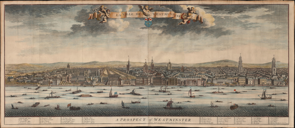
La Ville de Westmunster. / A Prospect of Westminster.
1724 (dated) 19 x 44.5 in (48.26 x 113.03 cm)
1724 (dated) 19 x 44.5 in (48.26 x 113.03 cm)
Description
This beautiful, meticulously detailed 1724 panorama of West London was produced by Dutch engravers Johannes Kip and Leonard Knyff for inclusion in Britannia Illustrata. It is one of the grandest views of West London obtainable.
A Closer Look
The engraving presents a panorama of Westminster, seen from the south bank of the River Thames. The view captures Westminster as a flourishing, cosmopolitan city. Key structures are numbered and identified in the printed legend below the view. In the background, the hills of Kensington, Hempstead, and Highgate are labeled. The Thames teems with the small boats characteristic of the river traffic upriver from London Bridge. The image pre-dates the construction of Westminster Bridge by about 20 years. Westminster Abbey, the Parliament, Buckingham Palace, Covent Garden, and many other landmarks appear and are keyed to the legend: the skyline of the city is dominated mostly by church spires.A Monument of British Engraving
This work appeared in Kip's five-volume Nouveau Théâtre de la Grande Bretagne, a production reflecting the burgeoning British print market. The bilingual titles of the view - French and English - show the publishers' intentions to sell not only in England but also on the Continent.Publication History and Census
This scarce panorama, engraved on two joined sheets, was drafted by Johannes Kip and probably engraved by Joseph Smith for inclusion in Kip's Britannia illustrata. That work, published initially by David Mortier, passed to Smith in 1724. At some point between 1720 and 1724, Smith added his imprint to the lower cartouche, distinguishing this example as the second of 2 states. While it does appear on the market from time to time, we see the separate sheet listed by only 2 institutions in OCLC: the Bibliothèque National de France, and the British Library.CartographerS
Johannes "Jan" Kip (1652 or 53 - 1722) was a Dutch draftsman, engraver and print dealer. Together with Leonard Knyff, he made a speciality of engraved views of English country houses and towns. Kip learned his trade under Stopendaal from 1668 to 1670. His own work began to appear in 1672. After producing works for the court of William ofOrange in Amsterdam, Kip relocated to London (following King William III and Queen Mary II in the 'Glorious Revolution' of 1688.) He then travelled around England documenting notable estates. to found a successful printselling business. He worked as an illustrator for other London publishers as well as his own. He is perhaps best known for the folio illustrations he produced for the 1708 Britannia Illustrata, 1708 and 65 plates he engraved for Sir Robert Atkyns' 1712 The Ancient and Present State of Glostershire, and for Le Nouveau Théâtre de la Grande Bretagne, 1715. More by this mapmaker...
Joseph Smith (fl. 1697-1731) was a British engraver and publisher of maps and views in the first part of the 18th century. He worked with Henry Overton, Johannes Kip, and an array of other authors; there is no record of his education or other life dates. Notably, he assisted publisher David Mortier in the production of Johannes Kip's Britannia Illustrata, of which he would take over production in 1724. Learn More...
Source
Kip, J. and Smith, J. Nouveau Théâtre de la Grande Bretagne, (London: Smith) 1724.
Condition
Excellent. One marginal mend with no loss.
References
OCLC 557915837.