This item has been sold, but you can get on the Waitlist to be notified if another example becomes available, or purchase a digital scan.
1943 Dolph City Plan or Map of Palm Beach and West Palm Beach, Florida
WestPalmBeachPalmBeach-dolph-1943$200.00

Title
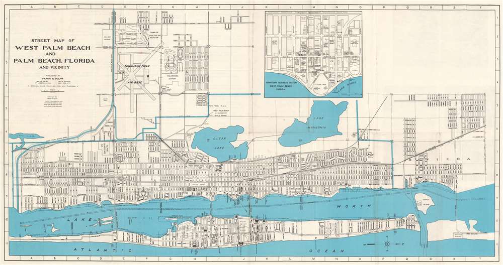
Street Map of West Palm Beach and Palm Beach, Florida and Vicinity.
1943 (undated) 16.25 x 31 in (41.275 x 78.74 cm) 1 : 42240
1943 (undated) 16.25 x 31 in (41.275 x 78.74 cm) 1 : 42240
Description
This is a c. 1943 Frank B. Dolph city plan or map of West Palm Beach and Palm Beach, Florida, during World War II. Throughout the war, Palm Beach was a training ground for American troops and a target for German attacks - 8 ships were sunk off Pam Beach by German U-Boats. The map is oriented to the east. The Florida East Coast Railway cuts its way through West Palm Beach and its passenger station and freight depot are both identified. Clear Lake, Lake Mangonia, and Lake Worth are all illustrated. Morrison Field Air Base, a U.S. Army Air Corps base, opened in 1942 and operated as a military installation until it closed in 1962, when it was known as Palm Beach Air Force Base. An inset, situated just to the right of center, details the downtown business section of West Palm Beach. Department stores (including Montgomery Ward and Company and J.C. Penney), real estate offices, churches, the telephone company, and the county courthouse are among the labeled locations.
Publication History and Census
This map was created and published by Frank B. Dolph c. 1943. We see no institutional holdings and no market history.Cartographer
Frank B. Dolph (October 3, 1897 - November 26, 1975) was an American businessman and map publisher. Born in Great Neck, Long Island, New York, Dolph served as a Navy storekeeper during World War I. He began selling maps in 1919 after returning from England, likely for the George F. Cram Company, where he ultimately became an administrative aide. He also worked for the Rand McNally Company for some time before he founded his own map publishing firm, Dolph and Stewart, with his friend, sometime in the 1920s. Dolph and Stewart made maps throughout the 1920s and 1930s until they sold the firm in 1945 when Dolph decided to return to Florida. Dolph opened a new map publishing business, the Frank B. Dolph Map Co. in Ft. Lauderdale and published city plans of cities throughout the United States. Many of his maps were distributed by Chambers of Commerce or sold at newsstands. Real estate developers greatly appreciated his maps, those published by both the Dolph and Stewart Company and the Frank B. Dolph Company. Dolph retired as president of his firm around 1965, when he handed the business off to his son, Frank B. Dolph, Jr. Dolph worked with cartographer Theodore M. Politano for decades while operating the Frank B. Dolph Map Company. More by this mapmaker...
Condition
Very good. Exhibits light wear along original fold lines. Verso repair to fold separation. Text on verso.