This item has been sold, but you can get on the Waitlist to be notified if another example becomes available, or purchase a digital scan.
1951 Rand McNally Road Map of West Palm Beach and Fort Lauderdale, Florida
WestPalmFortLauderdale-randmcnally-1951$100.00

Title
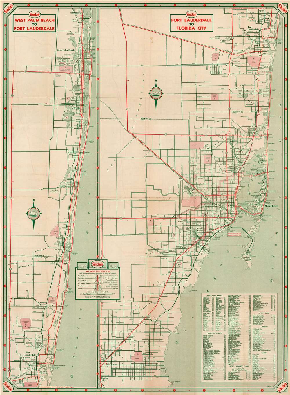
West Palm Beach to Fort Lauderdale. Fort Lauderdale to Florida City.
1951 (undated) 26.25 x 19.25 in (66.675 x 48.895 cm) 1 : 126720
1951 (undated) 26.25 x 19.25 in (66.675 x 48.895 cm) 1 : 126720
Description
This is a c. 1951 Rand McNally and Sinclair Oil road map of West Palm Beach and Fort Lauderdale, Florida. Divided into two sections, the left section highlights Highway 1 in red and other major roads between West Palm Beach and Fort Lauderdale in green. Country clubs, parks, golf courses, and airports are labeled in West Palm Beach, Boca Raton, and northern Fort Lauderdale. The right section depicts from Fort Lauderdale to Florida City in much the same manner, labeling cities, towns, and suburbs along the way. Both Highway 1 and the Tamiami Trail (Highway 41) are illustrated in red. An index situated in the lower right corner lists cities and towns, points of interest, golf and country clubs, yacht clubs, airports, and parks.
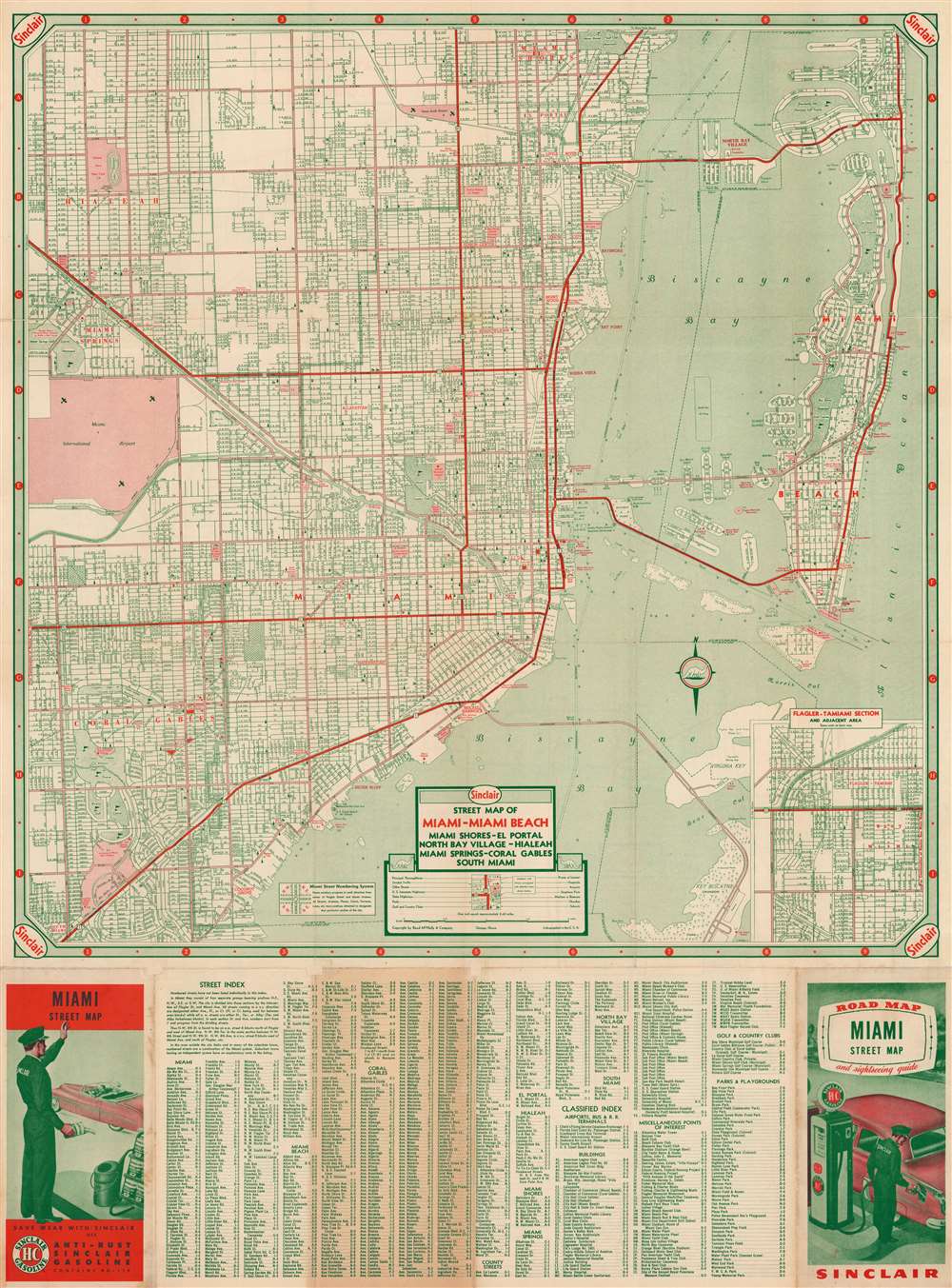
Verso Map - City Plan of Miami
A city plan of Miami and Miami Beach occupies the verso, with coverage extending from Miami Shores to South Miami and from Miami International Airport to Miami Beach. Major highways are highlighted in red while nearly every other street is green. Parks, country clubs, hospitals, post offices, and numerous other sites (including the Orange Bowl) are labeled. Icons mark schools and churches. An inset in the lower right corner focuses on the Flagler-Tamiami Section of West Miami. A street index is included along the bottom border.Publication History and Census
This map was created for Sinclair Oil by Rand McNally and published c. 1951.Cartographer
Rand, McNally and Co. (fl. 1856 - present) is an American publisher of maps, atlases and globes. The company was founded in 1856 when William H. Rand, a native of Quincy, Massachusetts, opened a print shop in Chicago. Rand hired the recent Irish immigrant Andrew McNally to assist in the shop giving him a wage of 9 USD per week. The duo landed several important contracts, including the Tribune's (later renamed the Chicago Tribune) printing operation. In 1872, Rand McNally produced its first map, a railroad guide, using a new cost effective printing technique known as wax process engraving. As Chicago developed as a railway hub, the Rand firm, now incorporated as Rand McNally, began producing a wide array of railroad maps and guides. Over time, the firm expanded into atlases, globes, educational material, and general literature. By embracing the wax engraving process, Rand McNally was able to dominate the map and atlas market, pushing more traditional American lithographic publishers like Colton, Johnson, and Mitchell out of business. Eventually Rand McNally opened an annex office in New York City headed by Caleb S. Hammond, whose name is today synonymous with maps and atlases, and who later started his own map company, C. S. Hammond & Co. Both firms remain in business. More by this mapmaker...
Condition
Good. Verso reinforcement to fold separations. Wear along original fold lines. Some toning. Small areas of infill at fold intersections. City plan or map of Miami on verso.