1728 Van Keulen Map of Elevations on the Western Coast of Sumatra, Indonesia
WestSumatra-vankeulen-1728$100.00

Title
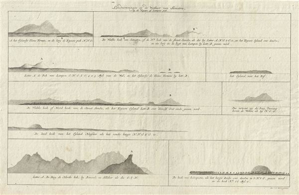
Landvertoningen op de Westkust van Sumatra, by de Keyzers of Lampons Piek.
1728 (undated) 12 x 18.5 in (30.48 x 46.99 cm)
1728 (undated) 12 x 18.5 in (30.48 x 46.99 cm)
Description
This is an impressive example of Joannes van Keulen's 1728 chart depicting the elevations of the western coast of Sumatra, Indonesia. The chart includes nine beautifully rendered elevation profiles, each depicting a different region of western Sumatra, including a profile of Indrapura (Indopuro), Mount Pasang above the clouds, Lampoon Peak, and the north corner of Sunda Strait, among others. The chart was created by Jan de Marre for inclusion in Joannes van Keulen's 1728 edition of De Nieuwe Groote Lichtende Zee-Fakkel.
Cartographer
Johannes Van Keulen (1654 – 1715) was a Dutch cartographer active in Amsterdam during the late 17th century. Van Keulen was the son of Lucas van Keulen. Van Keulen's firm, ‘In de Gekroonde Lootsman' (In the Crowned Pilot), was founded in 1678 and registered with the Amsterdam bookseller's guild as 'Cross staff-maker and bookseller.' (The cross-staff is a nautical instrument used to determine latitude.) Two years later, in 1680, they obtained a patent from the States General of Holland and West Friesland to publish nautical charts and atlases. Together with his partner, the cartographer Claes Janz Vooght, Van Keulen published numerous atlases and nautical charts, including the Zee Atlas and Nieuwe Lichtende Zee-Fakkel. It was a massive five-volume atlas containing more than 130 nautical charts. The Zee-Fakkel established the Van Keulen firm as the pre-eminent maker of Dutch sea charts in the late 17th and early 18th century. In 1714, one year before Johannes Van Keulen's death, his son, Gerard van Keulen (1678 - 1726), took charge. Gerard continued to update and republish the Zee-Fakkel until his own death in 1726. The firm was later passed on to Gerard's son, Johannes II Van Keulen (1704 - 1755), who significantly updated the atlas, especially with regard to Asia, issuing the 1753 4th Volume, known as the 'Secret Atlas'. The final editions of the atlas were published by Gerard Hulst van Keulen (1733 - 1801), Joannes II's son. The final true Van Keulen edition of the Zee-Fakkel was published posthumously in 1803. It is noteworthy that though ostensibly controlled by the Van Keulen men, it was the Van Keulen widows who maintained and managed the firm in the periods following their husbands' deaths. After the death of Gerard Hulst Van Keulen's son, Johannes Hulst Van Keulen, ownership of the family plates and business fell into the hands of the Swart family, who continued to publish until the company closed its doors 1885, ending a cartographic legacy spanning nearly 207 years. More by this mapmaker...
Source
Keulen, J. van, De Nieuwe Groote Lichtende Zee-Fakkel, (Amsterdam).
Condition
Very good. Original platemark visible. Blank on verso.