This item has been sold, but you can get on the Waitlist to be notified if another example becomes available, or purchase a digital scan.
1862 Hoffman and Knickerbocker Map of the West Washington Market, Manhattan
WestWashingtonMarket-hoffman-1862$200.00

Title
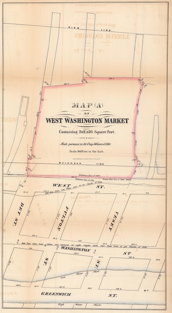
Map (A) of West Washington Market Containing 208,036 Square Feet.
1862 (undated) 17.5 x 9.5 in (44.45 x 24.13 cm) 1 : 969
1862 (undated) 17.5 x 9.5 in (44.45 x 24.13 cm) 1 : 969
Description
This is a fascinating 1862 Hoffman and Knickerbocker map of the West Washington Market in Lower Manhattan - a little-known page in NYC lore. This market, which housed stalls for private merchants and had its own 'street grid', stood where Brookfield Place Mall is today.
A Closer Look
Depicting Lower Manhattan from the Hudson River to Greenwich Street and from Vesey Street to Dey Street, the West Washington Market dominates the space west of West Street. Streets and city blocks are measured in feet and low and high water marks are illustrated.West Washington Market
The West Washington Market, an extension of the Washington Market (built between 1812 and 1813 between Fulton and West Streets), was built in 1858. It was located west of West Street between Dey and Vesey, on the Hudson River. It burned at least twice: once in 1860 and again in 1867. The market moved uptown in 1867 to Gansevoort Street and was across West Street from the Gansevoort Market. The new uptown West Washington Market sold meat, poultry, and dairy products. This 'new' market was demolished in 1954.Publication History and Census
This map was published by Hoffman, Knickerbocker and Company in 1862. We note one other cataloged example which is part of the collection at the New York Public Library.Cartographer
Hoffman, Knickerbocker and Co. (1856 - 1862) were lithographer and engravers based in Albany, New York. They were active at least from 1856 and as late as 1862. He firm was operated by Abraham J. Hoffman (1834 - 18??). The 'and Co.' was probably Richard H. Pease, another Albany lithographer. The firm may have been preceded by Hoffman and Co. the partnership dissolved in 1862 when Hoffman relocated to Chicago. Their corpus consisted of government publications, sheet music, book covers, maps, stationary, decorative lithographs, and more. More by this mapmaker...
Condition
Very good. Light offsetting.
References
New York Public Library Map Div. 14-1483.