This item has been sold, but you can get on the Waitlist to be notified if another example becomes available, or purchase a digital scan.
1892 U.S. Government Map of Wheat Production in Washington State
WheatColumbiaRiver-gov-1892$125.00

Title
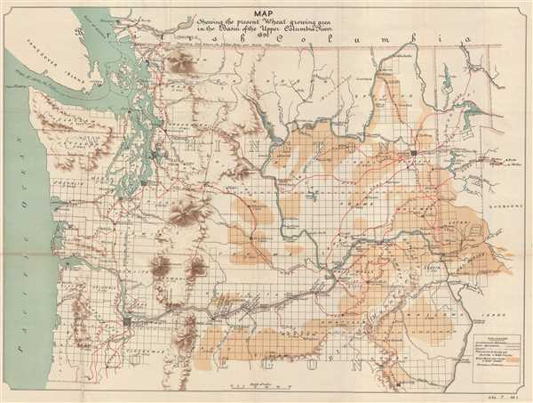
Map Szhowing the present Wheat growing area in the Basin of the Upper Columbia River.
1892 (dated) 22 x 29.5 in (55.88 x 74.93 cm) 1 : 972000
1892 (dated) 22 x 29.5 in (55.88 x 74.93 cm) 1 : 972000
Description
This is an 1892 U. S. Government map of Washington State. The map depicts the region from the Pacific Ocean and Vancouver Island to Idaho and from British Columbia to Oregon. A highly detailed land-use map, it illustrates the areas in which wheat is grown in Washington and northern Oregon. Shaded 'burnt umber', these areas are easily discernable, and are concentrated in eastern Washington mostly along river basins, particularly the Columbia and Snake Rivers. Aside from the distribution of wheat crops, cities and towns, such as Seattle, Tacoma, Olympia, Spokane, and Portland, are labeled and their population is given. Counties are also labeled and a land survey grid is overlaid across the entire map. Railroad lines operated by the Great Northern Railroad, the Northern Pacific Railroad, and the Union Pacific Railroad are labeled and appear on the map as red lines. Major and minor rivers are illustrated and labeled, along with mountain ranges.
This map was produced by the U.S. Government to accompany Secretary of War Daniel S. Lamont's Letter to the Senate transmitting the Report of the Board of Engineers regarding obstructions in the Columbia River published in 1893.
This map was produced by the U.S. Government to accompany Secretary of War Daniel S. Lamont's Letter to the Senate transmitting the Report of the Board of Engineers regarding obstructions in the Columbia River published in 1893.
Source
Lamont, D., 'Letter from the Secretary of War, Transmitting Report of Board of Engineers regarding obstruction in the Columbia River.', 53rd Congress, 1st Session. Ex. Doc. No. 7.
Condition
Very good. Backed on archival tissue for stability. Blank on verso.