This item has been sold, but you can get on the Waitlist to be notified if another example becomes available, or purchase a digital scan.
1903 F.D. Owen Map or Plan of the White House
WhiteHouse-owen-1903$275.00

Title
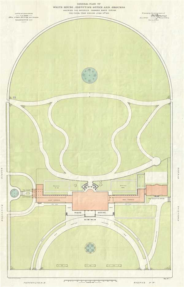
General Plan of the White House, Executive Office and Grounds Showing the Exterior Changes Made During the Fiscal Year Ending June 30th, 1903.
1903 (dated) 33.5 x 21.5 in (85.09 x 54.61 cm) 1 : 480
1903 (dated) 33.5 x 21.5 in (85.09 x 54.61 cm) 1 : 480
Description
This is a 1903 F. D. Owen map or plan of the White House and renovations undertaken by request of President Theodore Roosevelt, including the newly-constructed Executive Office (which would become the West Wing) and East Wing, Roosevelt's entrance for formal and public visitors. Oriented toward the south, the map depicts the much less sequestered White House grounds from East Executive Avenue to West Executive Avenue and from, what is known today as the South Lawn to Pennsylvania Avenue N.W. Numerous locations are labeled, including the White House, the Executive Office, the East and West Terraces, and the newly-built East Entrance. Several new roads are illustrated, mostly to the north of the White House. One 'watch' tower is located near the fence between the sidewalk and the South Lawn.
President Roosevelt's Renovations
Upon moving into the White House in 1902, President Roosevelt and his wife Edith decided that the Residence needed remodeling. The biggest change was the removal of the executive offices from the second floor of the White House into a new executive office. This allowed the Roosevelts to create a residence out of the entire second floor, once the remodeling was completed. Near the new social entrance, a long cloak room was constructed, to accommodate the coats and hats of the many visitor, particularly for the guests of large social gatherings. Today, this cloak room has been converted into the Family Theater. Per the Theodore Roosevelt Center
the effect of the renovations was to create the illusion, one observer of the time said, that the house was suddenly much larger. It was more open, lighter, and more welcoming. Pipes, boilers and radiator had been hidden from sight, and the new reception halls allowed for a greater flow of traffic, allowing the President to shake even more hands than before…The renovation successfully conveyed what Roosevelt had hoped to achieve: access to power, prosperity, dignity and quiet elegance.This map was drawn by F. D. Owen and included in a report by Colonel Thomas William Symons, the officer in charge of Public Buildings and Grounds of the District of Columbia in 1903.
CartographerS
Frederick D. Owen (1871 - January 28, 1931) was an American cartographer, engineer, and architect active in Washington D.C. in the late 19th and early 20th centuries. Owen was born in Connecticut, Owen was a civilian contractor with the U.S. Bureau of Topographical Engineers. He worked with the First Lady Caroline Harrison (1832 - 1892), wife of President Benjamin Harrison, to plan an ambitious expansion of the White House, but it was never realized. Seven of his maps are located in the Library of Congress. He created the maps that hung in the ‘War Room’ at the White House during the Spanish-American War (‘Frank Leslie’s Popular Monthly’, Vol. L, No. 2, 113.). Later, Owen worked for the Washington D.C. Parks department. More by this mapmaker...
Thomas William Symons, Jr. (1849 - 1920) was an American army officer and engineer. Born in Keeseville, New York, his family soon moved to Flint, Michigan. Upon completing high school, Symons applied to the U.S. Military Academy at West Point and graduated at the top of the Class of 1874. After West Point, Symons was commissioned as a Second Lieutenant in the Army Corps of Engineers and served at Willett’s Point for his first two years in the army. In 1876, Symons was reassigned to the Wheeler Expedition, which was one of the four major expeditions that formed the nucleus of the U.S. Geological Survey. By 1880, Symons had been promoted to Captain and was in charge of studying the area referred to as the ‘Inland Empire of the Pacific Northwest,’ focusing on the upper Columbia River and its tributaries. Other than exploring and mapping the region, Symons chose locations for new army outposts, built roads, and carried out other military duties. Over the course of the following years, Symons worked on the Mississippi River Commission, led the U.S. side of the joint boundary commission redefining the border with Mexico, and worked on several city projects in Washington, D.C. including the water supply, sewage system, and pavements. In 1895, Symons returned to New York where he was charged with planning and designing the river and harbor works at Buffalo. He was also named engineer of the 10th Lighthouse District, which encompassed all the waterways and lighthouses from Detroit, Michigan, to Ogdensburg, New York. In 1897 Congress commissioned a report researching the possibility of a ship canal spanning New York State. Symons disappointed the committee by stating in his report that a barge canal, not a ship canal, was the best option. In 1898, then Governor of New York Theodore Roosevelt enlisted the help of Symons to further study the canal project, and through this additional work succeeded in convincing Congress that this was indeed the best option. Roosevelt was elected President of the United States in 1902, and named Symons as his top military aide in early 1903. In D.C., Symons was officially the officer in charge of Public Buildings and Grounds of the District of Columbia (a post which was accompanied by a promotion to the rank of Colonel of Engineers). That, however, was not the extent of Symons’s duties for the president. As Roosevelt’s top military aide, Symons was the Master of Ceremonies for all White House functions. Symons planned, coordinated, and executed every appearance by Roosevelt, who was also a close personal friend. Depending on the event, Symons could have been responsible for selecting the decor, music, food, and entertainment. Symons became the public face of all White House events. He took his place at Roosevelt’s die in any reception line, greeting each guest and introducing them to the president. He was also the paymaster general of the White House, ensuring that all funds appropriated for expenses were properly spent. Symons was also allowed, by the authority of a special act of Congress, to help with the creation of New York’s barge canal while in office (this, of course, happened with a little help from President Roosevelt). Symons left the White House after Roosevelt’s first term in order to focus on the canal. After 37 years of service, the post of Chief Engineer of the Army Corps was going to open up in 1908. President Roosevelt strongly advocated for Symons to accept the position, but he elected to submit his name for the retirement list instead. Thomas William Symons, the map Theodore Roosevelt called the ‘Father of Barge Canals’ died in 1820. Learn More...
Condition
Very good. Wear along original fold lines. Closed tear extending two inches along left border professionally repaired on verso. Blank on verso.