This item has been sold, but you can get on the Waitlist to be notified if another example becomes available, or purchase a digital scan.
1887 Appalachian Mountain Club Map of the White Mountains, New Hampshire
WhiteMountains-amc-1887$500.00

Title
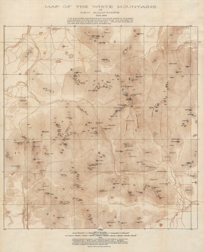
Map of the White Mountains of New Hampshire.
1887 (dated) 18.5 x 15 in (46.99 x 38.1 cm) 1 : 150000
1887 (dated) 18.5 x 15 in (46.99 x 38.1 cm) 1 : 150000
Description
This is the Appalachian Mountain Club's (AMC) earliest map of the White Mountains in New Hampshire, published in 1887. It is a seminal map produced by an organization synonymous with hiking in the White Mountains.
This map includes some interesting non-standard toponyms. For example, Crawford Notch appears here as the 'White Mt. Notch,' with the Boston and Lowell Railroad passing through it. The Dry River, which joins the Saco River west of Mt. Crawford, appears here as the 'Mt. Washington River.'
Overall, this map marks a significant improvement, especially in terms of topographic mapping, over earlier maps of the White Mountains, such as George Philips Bond's survey of the early 1850s (previously sold by us).
The AMC played a critical role in popularizing hiking the mountains as an invigorating outdoor activity, which popularized conservation, and in direct conservation efforts, such as political lobbying. For example, in 1882, it successfully lobbied the Massachusetts Legislature to pass the Public Domain Acts, which allowed cities and towns to set aside land for preservation and conservation.
A Closer Look
Covering an area from Jefferson, Mt. Starr King, and Gorham in the north to Woodstock, Conway, and Chocorua in the south, the map includes the peaks of the White Mountains, which are noted with their elevations throughout. Mount Washington, tallest of them all, appears at center towards top-right. Roads, railways (most of which were soon acquired by the Boston and Maine Railroad), waterways, hotels, and other local landmarks (such as the Franconia Iron Works) are also indicated. A legend at the bottom discusses notations used for various topographic features, while other symbols on the map are consistent with the standardized system developed by the AMC.This map includes some interesting non-standard toponyms. For example, Crawford Notch appears here as the 'White Mt. Notch,' with the Boston and Lowell Railroad passing through it. The Dry River, which joins the Saco River west of Mt. Crawford, appears here as the 'Mt. Washington River.'
Overall, this map marks a significant improvement, especially in terms of topographic mapping, over earlier maps of the White Mountains, such as George Philips Bond's survey of the early 1850s (previously sold by us).
Summiting Mt. Washington, the Easy Way
Hiking up Mt. Washington is no easy feat, and can be downright dangerous for the unprepared, especially given the equipment and dress prevailing at the time of this map's publication. Therefore, from the early days of the White Mountains' history as a vacation destination, various methods were devised to offer easier access to the summit. The path leading up the mountain's east side, starting near the Glen House, is a carriage road that eventually became the Mount Washington Auto Road (the first ascent by an automobile was completed in 1899). Meanwhile, the railroad departing from near Fabyan House to the west of the mountain is the famous cog railway, in operation since 1868, the first mountain-climbing cog railway in the world. Considered a mad scheme when proposed by Sylvester Marsh, it remains in operation and is still the world's second-steepest rack railway.America's Favorite Mountain Retreat
At the time of this map's publication, the White Mountains were the preferred rustic retreat of urbanites from Boston and New York City, especially in the summer, when the heat and smells of the city became oppressive. With railways providing ready access, an extensive economy emerged to cater to this clientele, including luxury hotels ('houses' here), which were directly accessed by the railways. Aside from passenger railroads, logging railroads also began to crisscross the region in the decades after the U.S. Civil War (some rail lines served both passengers and logging), allowing for a rapid expansion of the logging industry. Forests were clearcut throughout the White Mountains around the turn of the 20th century, but almost as quickly began to regrow. The establishment of the White Mountain National Forest in 1918, along with a decline of logging in northern New England, laid the groundwork for the magnificent forests of today.The AMC played a critical role in popularizing hiking the mountains as an invigorating outdoor activity, which popularized conservation, and in direct conservation efforts, such as political lobbying. For example, in 1882, it successfully lobbied the Massachusetts Legislature to pass the Public Domain Acts, which allowed cities and towns to set aside land for preservation and conservation.
The Appalachian Mountain Club
The Appalachian Mountain Club is one of the oldest outdoor recreation and conservation organizations in the United States. The organization was founded in 1876 in Boston by a group of avid mountaineers. One of the organization's first objectives was to map the mountains of New England, particularly the Whites. The year after this map's publication (1888), the AMC opened its first mountain hut (Madison Spring Hut) near Mt. Madison, providing weary hikers a place to rest or sleep overnight (it has since been renovated and rebuilt several times). In 1895, the AMC made its first purchase of land, protecting 36 acres along Snyder Brook (the middle of the three brooks running south of Randolph perpendicular to the Moose River, towards top-right here) from logging operations (it was later incorporated into the White Mountain National Forest). In 1907, it published the first edition of its guide (Appalachian Mountain Club White Mountain Guide), which has since been used as an essential resource by many thousands of hikers. Ever since, the AMC has been an instrumental part of hiking in the White Mountains, building many more huts, marking and maintaining trails, and producing essential maps.Publication History and Census
This map was produced by the Appalachian Mountain Club and issued as a folding map in 1887, the first map of the region it issued for public use. The folding map was issued in two editions, one at a scale of 100,000, which is slightly larger, and the present edition at a scale of 150,000. Regardless of edition, the OCLC notes the map appearing in the holding of some fifteen institutions in the OCLC, while the New Hampshire Historical Society also holds an example.Condition
Very good. Slight wear on old fold lines.
References
OCLC 14960028, 950517615. New Hampshire Historical Society Accession / Call Number 3350.