This item has been sold, but you can get on the Waitlist to be notified if another example becomes available, or purchase a digital scan.
1888 Leavitt Pictorial Map of the White Mountains
WhiteMountains-leavitt-1888$700.00

Title
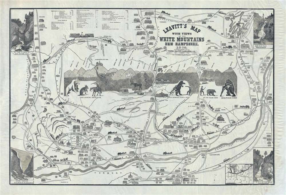
Leavitt's Map with Views of the White Mountains, New Hampshire.
1888 (dated) 21 x 31 in (53.34 x 78.74 cm)
1888 (dated) 21 x 31 in (53.34 x 78.74 cm)
Description
Complete with frightening bears, this is Franklin and Victor Leavitt's idiosyncratic 1888 pictorial map of New Hampshire's White Mountains. The folksy map depicts the region from the Androscoggin River to the Connecticut River and from Lake Winnipesaukee to Concord, Vermont. Drawn in Leavitt's own quirky style, the charm of this map is immediately apparent. Created with a tourist in mind, individual hotels and great estates are illustrated in profile throughout the map. Local history abounds, some of which is actual, some of which is pure legend, many of which involve the daring exploits of locals hunting. A view of the White Mountains is situated in the center, with the illustrated peaks labeled and their elevations given (though rounded to the nearest 100 feet). Roads and railroads crisscross the region, nearly all of which are labeled, and illustrations of horse-drawn carriages adorn the roads and while trains run along their tracks. Views of four different waterfalls are situated in each of the corners and an inset map of the rail routes from Boston is included on the lower right.
Census and Publication History
This map was drawn by Franklin Leavitt and originally published by him in 1882. It is part of a series of White Mountain maps published by Leavitt between 1852 and 1888. The present example is the second state, which was published by his son Victor Leavitt in 1888. Leavitt sold the maps himself at grand hotels and even train stations. Examples of the map appear in several institutional collections, but all of Leavitt's maps are rare on the private market.Cartographer
Franklin Leavitt (1824 - 1898) was an American 'jack-of-all-trades' who held jobs as a guide, hotelier, and contractor, and also aspired to be an artist and poet. Born in or near Lancaster, New Hampshire, Leavitt worked in the Notch House, an inn near Crawford Notch, as a young man, and also helped build trails and the Carriage Road (now the Auto Road). With the advent of a rail connection into the White Mountains, Leavitt apparently came to the conclusion that tourists would soon follow, and would create a market for a souvenir tourist map. He drew one and took it to one of the best printers in Boston to be printed. Leavitt then sold the maps himself in hotels and train stations throughout the region. By the time of his death, Leavitt had created six different pictorial tourist maps of the White Mountains. More by this mapmaker...
Condition
Very good. Even overall toning. On thin paper. A few minor outer margin repairs.
References
OCLC 16100276. Cobb, D., New Hampshire Maps to 1900, #425. Tatham, D., 'Franklin Leavitt’s Pictorial Maps of the White Mountains', from Prints of New England. ed. Georgia Brady Barnhill (1991), pp. 125-126, 129 (illustrating 1882 ed.), 131.