This item has been sold, but you can get on the Waitlist to be notified if another example becomes available, or purchase a digital scan.
1903 Scarborough / National Publishing Map of the White Mountains, New Hampshire
WhiteMountains-nationalpublishing-1903$150.00


Title
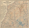
Scarborough's Topographic Map of the White Mountains and Central New Hampshire.
1903 (undated) 36.5 x 38.25 in (92.71 x 97.155 cm) 1 : 126720
1903 (undated) 36.5 x 38.25 in (92.71 x 97.155 cm) 1 : 126720
Description
This large and impressive map of the White Mountains and central New Hampshire was published by the Scarborough Company, successor to the National Publishing Company, in 1903. It displays the region on the eve of the automobile era, when it was a favorite retreat of well-heeled tourists from Boston, New York, and beyond.
Counties are demarcated and identified, and rivers and lakes are colored blue and labeled. Mountains are illustrated using contour lines, labeled, and their elevations provided. An index along the left side lists post offices, railroad stations, principal lakes and streams, and principal mountains, and provides the grid location for each one.
At the time of this map's publication, the White Mountains were the preferred rustic retreat of urbanites from Boston and New York City, both in the summer, when the heat and smells of the city became oppressive, and in the winter, as the mountains offered skiing and scenery that could not be had in an urban environment. With railways providing ready access, and entire economy grew to cater to this clientele, including luxury hotels such as the famed Mount Washington Hotel (in later decades, especially as automobiles became more widespread and affordable, tourists from a wider socioeconomic stratum began visiting the area in large numbers).
That being said, the White Mountains did not resemble the forested wonderland that one witnesses today. The logging industry was perhaps the only one which superseded tourism, resulting in the clearcutting of forests throughout New Hampshire in the late 19th and early 20th century. The establishment of the White Mountain National Forest in 1918, along with a decline of logging in northern New England, reversed this trend, laying the groundwork for the magnificent forests of today.
A Closer Look
Coverage embraces central New Hampshire from Lancaster and Berlin Mills south to Lake Winnipesaukee, Cornish, South Danbury, and Alton Bay. Many individual peaks throughout the White Mountains are noted. Cities, towns, and villages are labeled, with communities served by post offices and railroad stations labeled as such. Grants and purchases around the area are labeled in different typefaces, with some marked in large bold lettering, while others, like the Allen grant in Waterville County, are much less noticeable.Counties are demarcated and identified, and rivers and lakes are colored blue and labeled. Mountains are illustrated using contour lines, labeled, and their elevations provided. An index along the left side lists post offices, railroad stations, principal lakes and streams, and principal mountains, and provides the grid location for each one.
America's Favorite Mountain Retreat
Roads are illustrated, as are several railroads, including the Northern Division and the White Mountain Division of the Boston and Maine Railroad and several abandoned lumber railroads. Although not labeled as such, the 'Mt. Washington Ry.' Departing from Bretton Woods is the famous cog railway, the first such mountain-climbing cog railway in the world, already in operation 35 years by this point. The Mount Washington Auto Road, originally intended for carriages, is also visible (the first ascent by an automobile was completed only four years prior in 1899).At the time of this map's publication, the White Mountains were the preferred rustic retreat of urbanites from Boston and New York City, both in the summer, when the heat and smells of the city became oppressive, and in the winter, as the mountains offered skiing and scenery that could not be had in an urban environment. With railways providing ready access, and entire economy grew to cater to this clientele, including luxury hotels such as the famed Mount Washington Hotel (in later decades, especially as automobiles became more widespread and affordable, tourists from a wider socioeconomic stratum began visiting the area in large numbers).
That being said, the White Mountains did not resemble the forested wonderland that one witnesses today. The logging industry was perhaps the only one which superseded tourism, resulting in the clearcutting of forests throughout New Hampshire in the late 19th and early 20th century. The establishment of the White Mountain National Forest in 1918, along with a decline of logging in northern New England, reversed this trend, laying the groundwork for the magnificent forests of today.
Publication History and Census
This map was created and published by the Scarborough Company of Boston, Massachusetts around the year 1903, based on a slightly earlier map (previously sold by us) by the National Publishing Company. This map is listed among the holdings of eight institutions in the OCLC, while the earlier printing under National Publishing is held by nine.CartographerS
Scarborough Company (1885 - 1913) was founded by the brothers Walter C. Scarborough (June 4, 1862 - May 9, 1904) and Howard G. Scarborough (December 23, 1867 - June 10, 1905). Walter, the older brother, was born in Providence, Rhode Island, and studied at the Boston University Law School. The Scarborough brothers founded their map publishing concern in 1885. Initially, there were three separate firms: the National Publishing Company (Portland, Maine, 1897), later based in Boston; the Dominion Publishing Company, based in Canada; and the Scarborough Publishing Company, based in London. These three firms each published semi-independently but were merged with a capital of 1,000,000 USD in 1902, subsequently publishing under the Scarborough imprint. Howard took over full management of the Scarborough in 1904 when Walter died. Howard was also in poor health, suffering from tuberculous, and relocated to Europe in 1900, where he lived in a sanatorium. He returned to the United States in 1902, settling first in Asheville, North Carolina, then at a sanatorium community in Oracle, Arizona. Until his death, he managed the Scarborough Company remotely. From about 1904, there was another branch of the firm located at 227 East Ohio Street in Indianapolis, Indiana. After Howard's 1905 death, the management of the firm, as well as its principal manufacturing and distribution points, was relocated to Indianapolis. In 1913, it became the Scarborough Motor Guide Company (c. 1913 - c. 1933). More by this mapmaker...
National Publishing Company (1897 - 1902) was an American map publishing firm founded in Portland, Maine in 1897. The founders, brothers Walter C. Scarborough (June 4, 1862 - May 9, 1904) and Howard G. Scarborough (December 23, 1867 - June 10, 1905), were also proprietors of the Scarborough Company and the Dominion Publishing Company. The National Publishing Company was intended to be managed by Howard, with Walter serving as treasurer. By 1901, the firm had relocated to Boston, where it published and sold large scale brilliantly printed road maps. In 1902, the Scarborough brothers merged their three concerns into the Boston based Scarborough Company and opened an office in Indianapolis, Indiana. Walter and Howard died in 1904 and 1905, both from tuberculous, but the Scarborough Company continued, transferring its offices to Indianapolis. In 1913 it became the Scarborough Motor Guide Company (c. 1913 - c. 1933). It does not appear to be related to the more prominent general publisher of the same name based out of Philadelphia. Learn More...
Condition
Very good. Mounted on linen. Light wear along original fold lines.
References
OCLC 1058707.