This item has been sold, but you can get on the Waitlist to be notified if another example becomes available, or purchase a digital scan.
1921 Langford Oil Company Oil Fraud Map of Wichita Falls, North Texas
WichitaFallsOil-langford-1921$1,500.00

Title
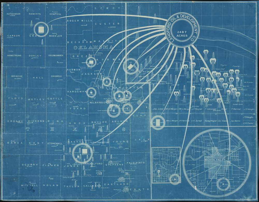
Langford Oil and Development Co. 2487 Acres.
1921 (undated) 23.5 x 30.25 in (59.69 x 76.835 cm)
1921 (undated) 23.5 x 30.25 in (59.69 x 76.835 cm)
Description
A striking c. 1921 cyanotype persuasive map illustrating oil fields around Wichita Falls, Texas, associated with the Langford Oil Fraud. Comprising four maps in one, the blueprint focuses on the Texas-Oklahoma border area along the Red River, illustrating county boundaries, supposed oil strikes and oil fields, including Kemp-Munger-Allen, Burk Burnett, Electra and Park Fields in Wichita County. Oil Derricks overlay the map to illustrate active drilling as well as successful strikes, such as the Kemp-Munger-Allen well, which is gushing. Wells claimed by Langford are highlighted with white circles connected to the title cartouche by dramatic 'swooshes' reminiscent tentacles. The present map is a cyanotype, a photo-reprographic method used for small run reproductions of less than 15 prints. It bears manuscript annotations on the left side naming additional counties and possibly property holders - suggesting that this was a working map used by the Langford firm.
Hosea Andrew Langford (1874 - 1926) Oil Fraud
Hosea Andrew Langford was a Georgia native who, seeking riches, followed the oil boom to Texas and Oklahoma, where contemporary references describe him as an 'oil worker.' Around 1918, he partnered with several others to established the Langford Oil and Development Company in Wichita Falls, a sham organization based out of several Wichita Falls flop houses. The firm's primary address was at the Oil Exchange Building at 721A Ohio Street, considered the 'roughest street in Wichita Falls,' 'where small-time operators could rent offices.' The firm produced propaganda material (like this map) and press releases which were sent east through a series of 'dupe' representatives and intermediaries conned into soliciting investments and selling land to speculating easterners. Despite the impressive printed propaganda, suggesting the potential for unimaginable wealth, a close study of the map, which features some two dozen gushing wells, reveals that none are on land actually owned by the Langford Company! Moreover, a 1921 letter from the Texas Railroad commission revealed that there was no record of the Langford Oil and Development Company ever actually drilling. It is no mistake that Hosea Andrew Langford shares a name with W. S. Langford, a legitimate oil tycoon responsible for much of Wichita Falls’ actual oil boom, and this is likely the reason he was chosen to front the con operation.Texas Oil Boom
Lasting roughly from 1901 to 1940, the Texas Oil Boom, or Gusher Age, was born with the Lucas Gusher at Spindletop. This first major gusher launched a boom period of extensive drilling and economic development throughout Texas. The major petroleum strikes began in Southeast Texas, but soon reserves were found across Texas and wells were constructed in North Texas, East Texas, and the West Texas Permian Basin, with most of the financial benefit going to Houston. Like most natural resource booms, the Texas Oil Boom drew countless fortune seekers, some honest workers and businessmen, others, like Langford, eager to exploit hopes and dream to fleece the unwary.Cyanotype: Why so Blue?
Cyanotype is a photo-reprographic technique developed in 1842 by the British astronomer John Herschel (1792 - 1871). Sometimes called a 'sunprint', the technique employs a solution of ferric ammonium citrate and potassium ferricyanide, which painted on white paper or cloth, reacts when exposed to sunlight to dye the object a brilliant blue. Areas blocked from ultraviolet exposure remain undyed and white. Herschel developed the technique to reproduce his astronomical notes, but others quickly realized that any object capable of blocking light could be used to quickly and easily create a cyanotype image. By the late 19th century the process became popular with designers, military, architects, and engineers (blueprints), who used the cheap an effective technique to quickly and exactly reproduce images in the field. Cyanotyping is limited in that only a single copy can be made at one time, so it was only practical for short-term field work. It is also of note that cyanotypes remain extremely reactive to light and, over time, fade or degrade, making them extremely ephemeral. The process fell out of fashion in most places by the 1920s, but remains in use in some parts of the world, such as India and Nepal, to this day.Publication History and Census
Printed in cyanotype by the Langford Oil and Development Company sometime between 1919 and 1921. Appears to be the only known example.Condition
Very good. Cyanotype. Some wear and slight loss on original fold intersections.