This item has been sold, but you can get on the Waitlist to be notified if another example becomes available, or purchase a digital scan.
1867 Weyss Map of the U.S. Civil War Battlefield of the Wilderness, Virginia
Wilderness-weyss-1867$150.00

Title
The Wilderness.
1867 (dated) 31 x 19 in (78.74 x 48.26 cm) 1 : 21120
1867 (dated) 31 x 19 in (78.74 x 48.26 cm) 1 : 21120
Description
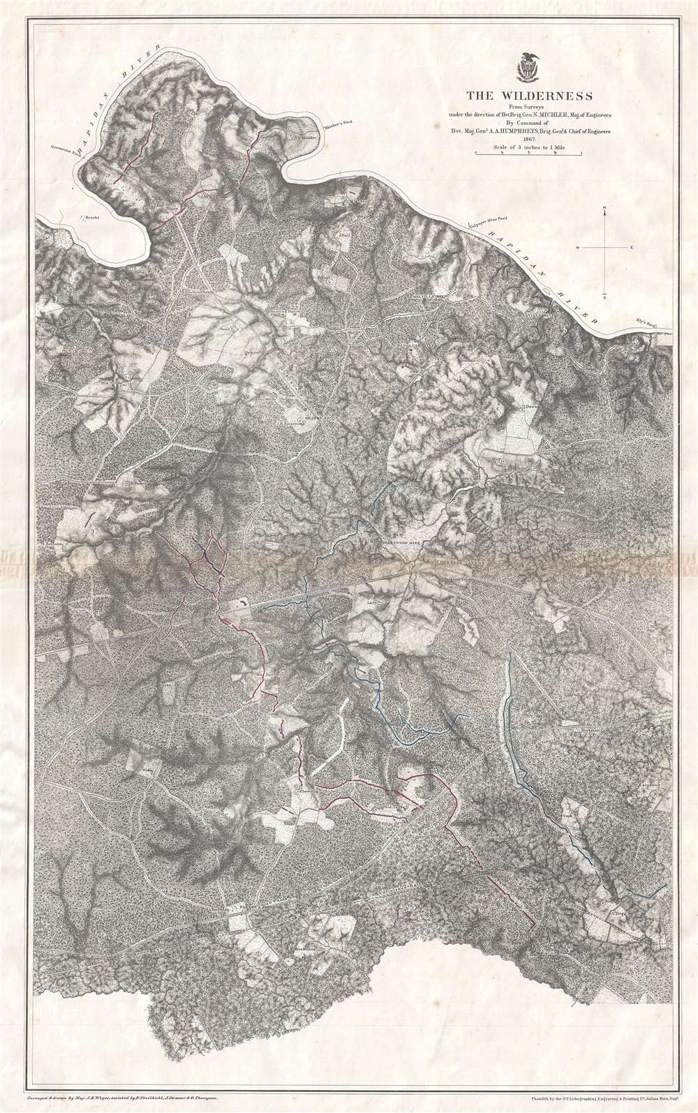
This is an 1867 John Weyss and Nathaniel Michler map of the battlefield of the Wilderness in Virginia. The map depicts the region from Brook's Ford on the Rapidan River to the Carpenter homestead and from Rapidan River to Miss Billion's homestead. The first battle in General Ulysses S. Grant's Overland Campaign against Robert E. Lee's Army of Northern Virginia, the Battle of the Wilderness ended in a strategic stalemate. Nonetheless, Grant was undeterred and did something no other Union commander had up to that point in the war: he continued on the offensive instead of retreating. By continuing his push deeper into Virginia, even though the Army of the Potomac had suffered catastrophic casualties, Grant won the admiration and support of his soldiers, as they were convinced that the commander of the Army of the Potomac would finally lead them to victory.
The Battle of the Wilderness
Fought bewteen May 5-7, 1864, the Battle of the Wilderness was fought in a dense forest south of the Rapidan River in northern Virginia. Union forces under General Warren crossed the Rapidan on the morning of May 5 at Germanna Ford (labeled here in the upper left quadrant) and proceeded through the underbrush toward Spotsylvania Court House. General Warren and General Meade both believed that General Lee and his army would take up defensive positions several miles away, thus neither believed a battle was imminent, and General Warren ordered his men to make camp around Wilderness Tavern (labeled here). However, the following day, Warren received word that Confederate infantry was advancing along Orange Turnpike (illustrated here and is the upper of the two roads running from left to right across the page) and received orders to engage them. Fierce fighting ensued, along the Turnpike, and soon another Union General, Samuel Crawford, was fighting a Confederate force advancing along the Orange Plank Road (also labeled here). Fighting continued until night fell, when everyone withdrew for the night. These battle lines are approximately illustrated here, with Federal defenses colored in blue, while Confederate lines are shaded red. The following day, May 7, both sides were dug in a prepared for another day of fierce combat. Grant, however, realized that nothing could be gained from continuing to fight here, and ordered Meade and his army to withdraw from their earthworks that night and continue on to Spotsylvania Court House.Publication History and Census
This map was surveyed and drawn by Major John E. Weyss under the command of Nathaniel Michler, engraved by Julius Bien, and published by the War Department in Military Maps illustrating the Operations of the Armies of the Potomac and James in 1869. While this map is well represented in institutional collections, it is rarely on the private market.CartographerS
John E. Weyss (1820 - June 24, 1903) was an Austrian-American illustrator, cartographer, and engineer. Born in Vienna, Weyss immigrated to the United States in 1848 and settled in New York. He served as a member of the U.S. Government's Mexican Boundary Survey (1849 - 1855), led by Major William Hemsley Emory, because of his training as an illustrator. In the capacity of a civilian artist working for the army, Weyss contributed several illustrations for Emory's report, which was published in 1857-59. Weyss is also credited on eleven of the report's maps. At the outbreak of the American Civil War, Weyss held a position as a civil engineer for the state of Kentucky. Weyss received a commission as a major from the Governor of Kentucky and, due to his professional experience, was assigned to the staff of Captain Nathaniel Michler, the chief topographical officer in the Army of the Ohio. In this role he did survey work for maps of the vicinity of Shiloh and Corinth, both sites of major Civil War battles. Weyss then joined Captain Michler when he moved to the staff of General Rosecrans in late 1862, for whom they made a series of maps of the Battle of Stones River. Weyss and Michler were then transferred to the Army of the Potomac in May, 1863. One of Weyss's first assignments for the Army of the Potomac was a map of the vicinity of Harper's Ferry, Virginia, for which he produced a highly detailed map of the very complex topography of the region. Soon, Weyss was made responsible for the day-to-day detailed mapping during the siege at Petersburg. After the war, Weyss served as the principal surveyor under the direction of Michler during the creation of the atlas Military maps illustrating the operations of the armies of the Potomac and James, May 4th 1864 to April 9th 1865, that was published in 1869. Weyss served the U.S. Army Corps of Engineers for another twenty years, until he retired sometime in the 1880s. Weyss died on June 4, 1903, in Washington, D.C. More by this mapmaker...
Nathaniel Michler (September 13, 1827 - July 17, 1881) was an American military officer and mapmaker who served during the American Civil War. Born in Easton, Pennsylvania, Michler attended West Point, from which he graduated seventh in his class. Commissioned as a 2nd Lieutenant in the Topographical Engineers, Michler participated in the Mexican Boundary Survey from 1851 until 1857, when he was transferred to serve as the chief topographical engineer in surveys for a proposed canal from the Gulf of Darien to the Pacific Ocean from 1858 until 1860. He held the rank of Captain at the outbreak of the American Civil War and served with the Army of the Cumberland from 1861 - 1863, then was transferred to the Army of the Potomac and built defensive works for the Union Army at the Battles of the Wilderness, Spotsylvania, Cold Harbor, and Petersburg. He was promoted to Colonel in August 1864 and brevetted Brigadier General in April 1865. After the war, Michler served as superintendent in the District of Columbia until 1871 and from 1872 to 1875 was chief engineer with the General Commanding Division of the Pacific. He acted as military attaché for the United States Legation in Vienna, Austria from 1878 to 1880. Learn More...
Julius (Julien) Bien (September 27, 1826 - December 21, 1909) was a German-Jewish lithographer and engraver based in New York City. Bien was born in Naumburg, Germany. He was educated at the Academy of Fine Arts, Cassell and at Städel's Institute, Frankfurt-am-Main. Following the suppression of the anti-autocratic German Revolutions of 1848, Bien, who participated in the pan-German movement, found himself out of favor in his home country and joined the mass German immigration to the United States. Bien can be found in New York as early as 1849. He established the New York Lithographing, Engraving & Printing Company in New York that focused on the emergent chromo-lithograph process - a method of printing color using lithographic plates. His work drew the attention of the U.S. Government Printing Office which contracted him to produce countless government maps and surveys, including the Pacific Railroad Surveys, the census, numerous coast surveys, and various maps relating to the American Civil War. Bien also issued several atlases both privately and in conjunction with a relation, Joseph Bien. At the height of his career Bien was elected president of the American Lithographers Association. After his death in 1909, Bien's firm was taken over by his son who promptly ran it into insolvency. The firm was sold to Sheldon Franklin, who, as part of the deal, retained the right to publish under the Julius Bien imprint. In addition to his work as a printer, Bien was active in the New York German Jewish community. He was director of the New York Hebrew Technical Institute, the New York Hebrew Orphan Asylum, and president of the B'nai B'rith Order. Learn More...
Source
War Department, Military Maps illustrating the Operations of the Armies of the Potomac and James May 4th 1864 to April 9th 1865 including Battlefields of the Wilderness, Spottsylvania, Northanna, Totopotomoy, Cold Harbor, The Siege of Petersburg and Richmond Battlefields of Five Forks, Jetersville and Sailor's Creek, Highbridge, Farmville, and Appomattox Court-House. (Washington) 1869.
Military Maps Illustrating the Operations of the Armies of the Potomac and James, published in 1869, compiled all the maps created by Major Nathaniel Michler and Major John E. Weyss of all the major battlefields of the eastern theater of war during the American Civil War. These maps blended together surveys done by soldiers both before and during battles and work done by Weiss and his team of engineers after the war was over. Many of these maps were reduced in order to be republished in the Atlas to Accompany the Official Records of the Union and Confederate Armies, which has become the standard reference for Civil War military maps.
Condition
Very good. Toning along original centerfold. Closed margin tears professionally repaired on verso. Blank on verso.
References
Rumsey 3881.004. OCLC 40697009.