This item has been sold, but you can get on the Waitlist to be notified if another example becomes available, or purchase a digital scan.
1852 Sargent Public Survey Map of Wisconsin
Wisconsin-sargent-1852$112.50

Title
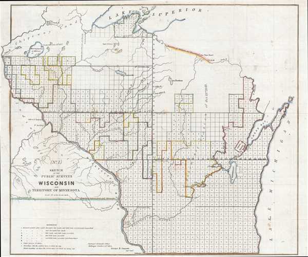
No. 1. Sketch of the Public Surveys in Wisconsin and Territory of Minnesota.
1852 (dated) 17.75 x 21.25 in (45.085 x 53.975 cm) 1 : 1140480
1852 (dated) 17.75 x 21.25 in (45.085 x 53.975 cm) 1 : 1140480
Description
This is an 1852 George Sargent map of Wisconsin. The map depicts the region from Lake Superior to the Wisconsin-Illinois border and from Minnesota and Iowa to Lake Michigan, Green Bay, and Michigan's Upper Peninsula. Created four years after Wisconsin's became the 30th state, this map illustrates the townships surveyed in Wisconsin. Each township bears a single letter, and this label corresponds to a list of references situated in the lower left corner. The township was created as the measure of the Public Land Survey System, which was first widely implemented to survey the Northwest Ordinance, of which Wisconsin was a part. The Public Land Survey System allowed for the systematic surveying and mapping of any territory gained by the United States.
As stated above, each township is labeled using a single capital letter. These labels indicate each township's status with regard to the cataloguing process of the Surveyor General's Office, which may contain information about how Wisconsin was settled. For example, any township labeled with a 'C' has presumably completed the checklist, meaning that it has been surveyed and platted, the plats have been copied, descriptive lists of the township have been made, and field notes have been recorded and transcribed, meaning that these were most likely the first ones to be settled. Townships labeled with and 'S', however, were only just being surveyed, and townships that are blank only have their exterior boundaries surveyed. These townships would not have had organized towns or settlements, but that does not mean that there were not American or immigrant settlers living in those parts of the state at that time.
State borders are labeled, such as those between Iowa and Minnesota and Wisconsin and Michigan. Several rivers and lakes are illustrated, including the Mississippi River (which forms the border between Wisconsin and Minnesota), Lake Winnebago, the Wisconsin River, the River St. Croix, and several other tributaries of the Mississippi. Indian territories are labeled as well, such as an Oneida Indian settlement near Green Bay and Chippewa Lands north of the surveyed territory in Minnesota. A handful of forts are labeled along the Mississippi, and the only town labeled is Dubuque, Iowa along the bottom border.
This map was created by the Surveyor General's Office in Dubuque and dated October 21, 1852. It was published in the Report of the Commissioner of the General Land Office, 1852.
Cartographer
The General Land Office (1812 - 1946) was an independent agency charged with the administration and sale of public lands of the western territories of the United States under the Preemption Act of 1841 and the Homestead Act of 1862. During a time of frenetic energy and rapid westward expansion, the Land Office oversaw the surveying, platting, mapping and eventually the sale of much of the Western United States and Florida. The structural layout of the western United States that we see today, and many of their district and county divisions, are direct result of the early surveying work of the General Land Office. More importantly, as a branch of the Federal Government in Washington D.C. and the only agency able to legally sell and administer public lands in the western territories of the United States, the General Land Office played a pivotal role in consolidating power away from the original states and into the hands of the centralized federal government. The General Land Office was absorbed into the Department of Interior in 1849 and in 1946 merged with the United States Grazing Service to become the Bureau of Land Management. Today the Bureau of Land Management administers the roughly 246 million acres of public land remaining under federal ownership. More by this mapmaker...
Source
Report of the Commissioner of the General Land Office, (Washington) 1852.
Condition
Very good. Backed on archival tissue for stability. Small tear extending three quarters of an inch in upper right quadrant. Writing on verso.
References
OCLC 714883192.