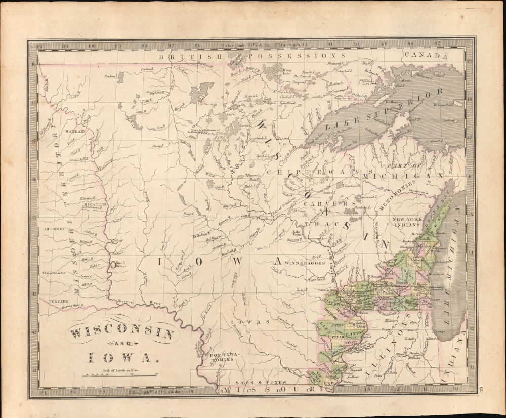
1842 Greenleaf Map of Wisconsin and Iowa
WisconsinIowa-greenleaf-1842$1,800.00

Title
Wisconsin and Iowa.
1842 (undated) 11 x 14 in (27.94 x 35.56 cm) 1 : 4000000
1842 (undated) 11 x 14 in (27.94 x 35.56 cm) 1 : 4000000
Description
This is the rare 1842 J. Greenleaf first-state map of Wisconsin and Iowa Territories, incorporating modern-day Minnesota. It illustrates the early days of U.S. settlement in the region, which, within a few years, penetrated westward as far as the Missouri - mainly at the cost of American Indian nations. It is also one of the few maps to illustrate Carver's Tract, an essentially fraudulent claim that was nonetheless used to leverage U.S. over American Indian claims to the region.
According to Carver's accounts, on this mission he received a vast land grant from the Naudowessie (a subgroup of the Dakota) as a reward for his 'many gifts'. Carver's claims were met with immediate controversy and accusations of fraud. Critics argue that there was no concrete evidence to support his claim, suggesting that the documents he produced were either forged or grossly misinterpreted. Moreover, the lands of his grant were not occupied by the Naudowessie, but rather by the Ojibwe, their mortal enemies. Despite efforts by Carver and his heirs to secure recognition for this grant in both American and British courts, the claims were fully dismissed by 1825.
Nonetheless, the tract appeared on maps well into the mid-19th century. Its presence here can be traced to its predecessor map, the 1836 David Burr map of Wisconsin Territory published for Z. Casey's report on the newly incorporated territory. Although the Carver claims were rejected by U.S. Courts by this time, they remained relevant within the context of official analysis of the territory, as well as for asserting U.S. claims over those of resident American Indians.
A Closer Look
Coverage embraces from Lake Michigan to the Missouri Territory and from the Lake of the Woods to Lee County, Iowa - which breaks the map's border. At the time, most of this land was American Indian territory, inhabited by Sioux, Dakota, and Ojibwe (Chippewa) groups. The map, nonetheless, reveals the initial stages of western settlement in Wisconsin and Iowa Territories. At this point, Wisconsin settlement was bounded on the west by the Wisconsin and Fox Rivers, and Iowa settlement extended no further west than 92°. It identifies Fort Snelling at the confluence of the Mississippi and St. Peter's Rivers, at the time a crucial center for trade, diplomacy, and interaction between the U.S. government and Native American tribes. The map also notes the 'New York Indians' near Green Bay, a reference to relocated Oneida, Stockbridge, Munsee, and Brothertown tribes.Jonathan Carver's Fraudulent Grant
The map illustrates a vast territory identified as 'Carver's Tract' in Wisconsin Territory along the Mississippi in the vicinity of Lake Pepin. Jonathan Carver (1710 - 1780) was a military surveyor, draftsman, and writer active in the mid to late 18th century. Carver served with distinction during the French and Indian War (1754 - 1763) under his friend and patron Robert Rogers, leader of Rogers' Rangers, a rough and ready frontier troop that employed American Indian fighting tactics on behalf of the British, turning the tide of the war. After the war, Rogers hired Carver as a draftsman on his expedition west of the Great Lakes in search of a water passage through America to the Pacific.According to Carver's accounts, on this mission he received a vast land grant from the Naudowessie (a subgroup of the Dakota) as a reward for his 'many gifts'. Carver's claims were met with immediate controversy and accusations of fraud. Critics argue that there was no concrete evidence to support his claim, suggesting that the documents he produced were either forged or grossly misinterpreted. Moreover, the lands of his grant were not occupied by the Naudowessie, but rather by the Ojibwe, their mortal enemies. Despite efforts by Carver and his heirs to secure recognition for this grant in both American and British courts, the claims were fully dismissed by 1825.
Nonetheless, the tract appeared on maps well into the mid-19th century. Its presence here can be traced to its predecessor map, the 1836 David Burr map of Wisconsin Territory published for Z. Casey's report on the newly incorporated territory. Although the Carver claims were rejected by U.S. Courts by this time, they remained relevant within the context of official analysis of the territory, as well as for asserting U.S. claims over those of resident American Indians.
Publication History and Census
The present example is the first edition from the 1842 Greenleaf New Universal Atlas. The map first appeared in 1842 (this example), again in 1848 and 1849, each edition featuring significant updates and revisions due to the rapid settlement and evolution of the territory. The map, like the Republic of Texas map, was appended to the atlas as an afterthought and thus appeared at the end of the volume, with an index entry added in manuscript, if at all. The map is very scarce to the market and does not appear in Rumsey. We do note 8 holdings in various American institutions.Cartographer
Jeremiah Greenleaf (1791 - 1864) is a little known but highly admired American cartographer of the early 19th century. He published from roughly 1830 to 1850. His most important work is A New Universal Atlas; Comprising of all the Principal Empires, Kingdoms, and States Throughout the World and Forming a distinct Atlas of the United States, published in several editions in the 1840s. Many of his maps are reformatted versions of his contemporary David Burr's much admired cartographic works. Greenleaf's maps are extremely rare and admired for their stunningly vivid pastel color washes. More by this mapmaker...
Source
Greenleaf, J., A New Universal Atlas, (Brattleboro, Vermont: French) 1842.
Condition
Very good.
References
OCLC 166634637. University of Michigan, Clements Library, #1015.