This item has been sold, but you can get on the Waitlist to be notified if another example becomes available, or purchase a digital scan.
1892 Rand McNally Map of the World w/Pork Advertising
WordMapReaPork-randmcnally-1892$100.00

Title
Rand, McNally and Co.'s Indexed Statistical Map of the World on Mercator's Projection. / Rea and Co., Pork and Beef Packers, Pittsburg.
1892 (dated) 19.5 x 26.5 in (49.53 x 67.31 cm) 1 : 64000000
1892 (dated) 19.5 x 26.5 in (49.53 x 67.31 cm) 1 : 64000000
Description
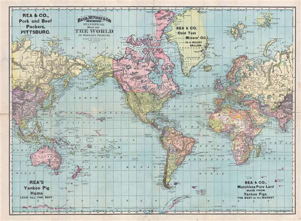
An interesting separate issue example of Rand McNally's c. 1892 map of the world, here repurposed as promotional material for Rea and Company. The map covers the entire world centered on North and South America and offers a fascinating snapshot of the world during a period of rapid globalization and discovery. Antarctic exploration was still in its infancy, though parts of the Antarctic coast line are noted to the south of Australia and off the coast of Tierra del Fuego. Vast stretches of unmapped territory and speculative cartography fill central Asia, South America, Canada, Africa and Australia.
Pork Product Advertising
The most striking aspect of this map is its repurposing to promote Rea and Company. Rea and Company were Pittsburgh based Pork and Beef backers active from the late 19th century to about 1912. What the firm hoped to gain from promoting their business via a cartographic medium is somewhat unclear. Their advertising, for 'Yankee Pig Hams,' Cold Test Miners' Oil,' and 'Matchless Pure Lard' is stamped rather haphazardly over the surface of the map wherever there is sufficient space, but make no sense in the context of the map's cartography.The Map's History
This map is typically found bound into various editions of Rand McNally's Indexed Atlas of the World where it is entitled Rand, McNally and Co's. Indexed Atlas of the World Map of the World. Here Atlas of the World is replaced with 'Statistical,' suggesting that Rand McNally must have also issued a pocket version. The date of this promotional piece is unclear. It bears the standard date of 1892, but was most likely a later 19h century printing wherein the copyright was not updated.Cartographer
Rand, McNally and Co. (fl. 1856 - present) is an American publisher of maps, atlases and globes. The company was founded in 1856 when William H. Rand, a native of Quincy, Massachusetts, opened a print shop in Chicago. Rand hired the recent Irish immigrant Andrew McNally to assist in the shop giving him a wage of 9 USD per week. The duo landed several important contracts, including the Tribune's (later renamed the Chicago Tribune) printing operation. In 1872, Rand McNally produced its first map, a railroad guide, using a new cost effective printing technique known as wax process engraving. As Chicago developed as a railway hub, the Rand firm, now incorporated as Rand McNally, began producing a wide array of railroad maps and guides. Over time, the firm expanded into atlases, globes, educational material, and general literature. By embracing the wax engraving process, Rand McNally was able to dominate the map and atlas market, pushing more traditional American lithographic publishers like Colton, Johnson, and Mitchell out of business. Eventually Rand McNally opened an annex office in New York City headed by Caleb S. Hammond, whose name is today synonymous with maps and atlases, and who later started his own map company, C. S. Hammond & Co. Both firms remain in business. More by this mapmaker...
Condition
Good. A few old splits. Backed on archival tissue.
References
Rumsey 3565.002 (1897 Atlas edition). Philip (atlases) 1026 (1898 Atlas edition).