This item has been sold, but you can get on the Waitlist to be notified if another example becomes available, or purchase a digital scan.
1631 Willem Blaeu Carte-a-figures Map of the World
World-blaeu-1630$7,500.00

Title
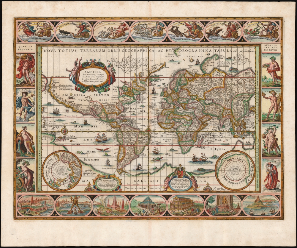
Nova Totius Terrarum Orbis Geographica ac Hydrographica Tabula. auct. Guiljelmo Blaeuw.
1630 (undated) 16 x 21.25 in (40.64 x 53.975 cm) 1 : 90000000
1630 (undated) 16 x 21.25 in (40.64 x 53.975 cm) 1 : 90000000
Description
This is Willem Blaeu's magnificent map of the world, considered the epitome of the carte á figures and the gold standard for decorative cartography of the Dutch Golden Age. Despite being created in 1606, it was the centerpiece map for Blaeu's Atlas Novus for nearly twenty years starting in 1630. It represented the dominant European image of the world for the first part of the 17th century, and remains the sine qua non for collectors of world maps, and of Dutch cartography.
The northern limit of the map's geographical information is Spitzbergen, here named Nieulandt, and shown incompletely. Nova Zembla's west coast is illustrated northwards to the point at which Barentz's famous final voyage wintered. Beyond this, the northern coasts of Asia are largely imaginary, and Blaeu's map does not speculate on the northernmost shores of America. The northern limits of the Atlantic - depicting the coast of Greenland, Iceland, and the phantom island of Frisland - reveal the long arm of Nicolo Zeno's fraudulent cartography. In spite of this, the Davis Strait and the discoveries of Frobisher are here recorded.
Blaeu's treatment of China, Japan, and Korea represents another nod to Ortelius, whose Portuguese Jesuit sources had not yet been surpassed. Korea appears as a narrow island. Asia and America are, as with Mercator and Ortelius, separated by the strait of Anian, separating Asia and America.
While by Blaeu's time the coastline of Africa was well understood, its interior was not: he follows Ptolemaic speculation regarding the sources of the Nile, mapping two speculative lakes in southern Africa. Lake Parima, thought to be a location of El Dorado, appears in South America. In North America, the cartographer maps the supposed Seven Cities of gold, noted as 'Ceptem Citta' - a legend dating to the saga of Álvar Núñez Cabeza de Vaca, the discoveries of the conquistador Francisco Vázquez de Coronado, and ancient Portuguese legends.
The map's artistry is not limited to its borders. It displays beautiful, clear, and legible calligraphy, ornate cartouches, and superb compass roses. The seas are liberally decorated with monsters, ships, and battles.
Mapping the Limits of European Exploration
Blaeu's map is laid out on the Mercator Projection, a mathematically challenging feat which few cartographers of Blaeu's era attempted. In many respects, however, it was an ideal form for Blaeu - since cartographers were ignorant of what lay at the poles during this period, the polar distortion inherent in the Mercator Projection mattered little. Two inset polar projections at the lower corners of the map reveal further the gaps in geographical knowledge of the extreme north and south. Both the southern polar projection and the main map exhibit the southern continent of Terra Australis, adopted by Blaeu from the 16th century authorities, Mercator and Ortelius. Blaeu's map, in its first state of 1606, depicted Tierra del Fuego as part of Terra Australis. He re-drew this area in the third state of the map, probably in 1617, showing the results of the Le Maire and Schouten voyage as on the present example. The southern continent reaches far enough north in the South Pacific to connect with New Guinea. The land of 'Beach' south of the East Indies appears, preserving Mercator's erroneous interpretation of Marco Polo's Locach, or Champa.The northern limit of the map's geographical information is Spitzbergen, here named Nieulandt, and shown incompletely. Nova Zembla's west coast is illustrated northwards to the point at which Barentz's famous final voyage wintered. Beyond this, the northern coasts of Asia are largely imaginary, and Blaeu's map does not speculate on the northernmost shores of America. The northern limits of the Atlantic - depicting the coast of Greenland, Iceland, and the phantom island of Frisland - reveal the long arm of Nicolo Zeno's fraudulent cartography. In spite of this, the Davis Strait and the discoveries of Frobisher are here recorded.
Blaeu's treatment of China, Japan, and Korea represents another nod to Ortelius, whose Portuguese Jesuit sources had not yet been surpassed. Korea appears as a narrow island. Asia and America are, as with Mercator and Ortelius, separated by the strait of Anian, separating Asia and America.
While by Blaeu's time the coastline of Africa was well understood, its interior was not: he follows Ptolemaic speculation regarding the sources of the Nile, mapping two speculative lakes in southern Africa. Lake Parima, thought to be a location of El Dorado, appears in South America. In North America, the cartographer maps the supposed Seven Cities of gold, noted as 'Ceptem Citta' - a legend dating to the saga of Álvar Núñez Cabeza de Vaca, the discoveries of the conquistador Francisco Vázquez de Coronado, and ancient Portuguese legends.
Surrounding the Map
A figured map - carte á figures - reinforced a regional map's cartographic data with imagery intended to give the reader an idea of the denizens of the land depicted, and the places they lived. Such a map focusing on a country, or a continent, would include figures of the nobles, soldiers, and commoners, and would include views of the chief cities. Such narrow focus is below the scope of a world map such as this, whose imagery is less related to geography than cosmography: focusing on the nature of the world and its place in a greater cosmos. The seven medallions at the top represent the sun, moon, and planets. These are represented by their associated Greek gods, and all of them, including the Sun, are depicted as charioteers. The implication that the Sun moves, like the moon and the planets, reflects a conventional geocentric model of the solar system. The lefthand border presents the four primary elements, while the right represents the seasons. Along the bottom, rather than contemporaneous cities, are illustrations of the Seven Wonders of the Ancient World: The Hanging Gardens of Babylon; the Colossus of Rhodes; the Great Pyramids; the Mausoleum of Halicarnassus; the Temple of Diana; the Temple of Jupiter; and The Great Lighthouse of Pharos.The map's artistry is not limited to its borders. It displays beautiful, clear, and legible calligraphy, ornate cartouches, and superb compass roses. The seas are liberally decorated with monsters, ships, and battles.
Publication History and Census
Blaeu's map was first engraved by Josua van den Ende in 1606. Its first three states are extremely rare, which were sold as separates having predated Blaeu's atlases. This is an example of the fourth state of the map, which first appeared without verso text in Willem Blaeu's 1630 Appendix. Thereafter, it was included in Blaeu's Theatrum Orbis Terrarum sive Atlas Novus from 1631 to 1655. The long publication history of this atlas has resulted in this being an acquirable map, but examples of this quality have grown scarce on the market.Cartographer
Willem Janszoon Blaeu (1571 - October 18, 1638), also known as Guillaume Blaeu and Guiljelmus Janssonius Caesius, was a Dutch cartographer, globemaker, and astronomer active in Amsterdam during the late 16th and early 17th centuries. Blaeu was born 'Willem Janszoon' in Alkmaar, North Holland to a prosperous herring packing and trading family of Dutch Reformist faith. As a young man, he was sent to Amsterdam to apprentice in the family business, but he found the herring trade dull and instead worked for his cousin 'Hooft' as a carpenter and clerk. In 1595, he traveled to the small Swedish island of Hven to study astronomy under the Danish Enlightenment polymath Tycho Brahe. For six months he studied astronomy, cartography, instrument making, globe making, and geodesy. He returned to Alkmaar in 1596 to marry and for the birth of his first son, Johannes (Joan) Blaeu (1596 – 1673). Shortly thereafter, in 1598 or 1599, he relocated his family to Amsterdam where he founded the a firm as globe and instrument makers. Many of his earliest imprints, from roughly form 1599 - 1633, bear the imprint 'Guiljelmus Janssonius Caesius' or simply 'G: Jansonius'. In 1613, Johannes Janssonius, also a mapmaker, married Elizabeth Hondius, the daughter of Willem's primary competitor Jodocus Hondius the Elder, and moved to the same neighborhood. This led to considerable confusion and may have spurred Willam Janszoon to adopt the 'Blaeu' patronym. All maps after 1633 bear the Guiljelmus Blaeu imprint. Around this time, he also began issuing separate issue nautical charts and wall maps – which as we see from Vermeer's paintings were popular with Dutch merchants as decorative items – and invented the Dutch Printing Press. As a non-Calvinist Blaeu was a persona non grata to the ruling elite and so he partnered with Hessel Gerritsz to develop his business. In 1619, Blaeu arranged for Gerritsz to be appointed official cartographer to the VOC, an extremely lucrative position that that, in the slightly more liberal environment of the 1630s, he managed to see passed to his eldest son, Johannes. In 1633, he was also appointed official cartographer of the Dutch Republic. Blaeu's most significant work is his 1635 publication of the Theatrum orbis terrarum, sive, Atlas Novus, one of the greatest atlases of all time. He died three years later, in 1638, passing the Blaeu firm on to his two sons, Cornelius (1616 - 1648) and Johannes Blaeu (September 23, 1596 - December 21, 1673). Under his sons, the firm continued to prosper until the 1672 Great Fire of Amsterdam destroyed their offices and most of their printing plates. Willem's most enduring legacy was most likely the VOC contract, which ultimately passed to Johannes' son, Johannes II, who held the position until 1617. As a hobbyist astronomer, Blaeu discovered the star now known as P. Cygni. More by this mapmaker...
Source
Blaeu, W, Theatrum Orbis Terrarum sive Atlas Novus, (Amsterdam: Blaeu) 1631-1655.
The classic Dutch atlas, whose publication ushered in the Dutch golden age of cartography. Willem Jansz Blaeu had been, since 1604, producing engraved maps for sale; these were separate issues (and all consequently extremely rare) until the publishing of Blaeu's Appendix in 1630 and 1631, which also included a number of maps purchased from the widow of Jodocus Hondius, (for example his famous iteration of John Smith's map of Virginia.) In 1634, he announced his intention to produce a new world atlas in two volumes, entitled Theatrum Orbis Terrarum, sive Atlas Novus (Théâtre du Monde ou Nouvel Atlas) (in an effort to invoke the successful work of the same title produced by Ortelius the previous century, while reinforcing the notion of it being a new work.) This work was published first in German in 1634, followed by Latin, Dutch and French editions in 1635. Blaeu's maps have always been noted for the quality of their paper, engraving and fine coloring, and this was the intent from the very start. The 1634 announcement of the upcoming work described it: 'All editions on very fine paper, completely renewed with newly engraved copperplates and new, comprehensive descriptions.' (van der Krogt, p,43) Many of the most beautiful and desirable maps available to the modern collector were printed and bound in Blaeu's atlases. Willem's son, Joan, would go on to add further volumes to the Atlas Novus, concurrently printing new editions of the first two volumes with additional maps, in effect making these new editions an entirely new book. Under Joan there would be nine Latin editions, twelve French, at least seven Dutch, and two German. This exceedingly successful work would be the mainstay of the Blaeu firm until 1661, at which point the work was supplanted by Joan Blaeu's masterwork Atlas Maior in 1662.
Condition
Excellent. Very faint toning at centerfold, else fine with superb hand color, generous margins and no mends.
References
Shirley, Rodney W., The Mapping of the World: Early Printed World Maps 1472-1700, #255 state 4. OCLC 21804934.