1897 Antoine Victor Dencède Wall Map of the World
World-dencede-1897$7,500.00


Title
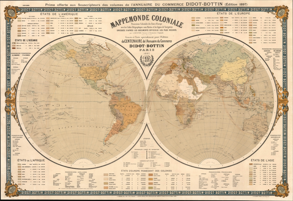
Mappemonde coloniale. Possessions coloniales des Etats de l'Europe avec les câbles télégraphiques sous-marins et les lignes de navigation...
1897 (dated) 35.5 x 53 in (90.17 x 134.62 cm) 1 : 34000000
1897 (dated) 35.5 x 53 in (90.17 x 134.62 cm) 1 : 34000000
Description
This scarce, grand Belle-Epoque chromolithograph map of the world was created by Antoine Victor Dencède as a supplement to subscribers to the Didot-Bottin Commercial Almanac of 1897, in celebration of the publication's hundredth year. From its beginnings as an annual business directory for Paris, the Didot-Bottin Annuaire de Commerce grew in scope by the end of the 19th century to include not only all of France but also foreign cities and France's colonies. Thus, a world map of this sort - highlighting European colonial interests around the globe and the steamship connections binding them together - would have been eagerly received.
A Closer Look
The map is drawn on double hemispheres, surrounded by an elegant border embellished with the 'Didot-Bottin' brand name and logo. The map uses a color code to indicate European colonial territories and show the national affiliations of specific commercial shipping routes. The routes are annotated with their endpoints, as well as the travel time in days. Railroads are marked on land. Heralding the revolution in communication then underway, the map also includes both surface and oceanic telegraph lines linking Europe to locations as remote as Tasmania and New Zealand. Extensive tables enumerate the populations of countries around the globe while also listing European colonial possessions - Great Britain and France appear to have the longest reach in this regard.The Edges of Exploration
Geographical features include recent discoveries approaching the poles. In the Arctic, the nearest lands to the Pole are Grant Land and Hall Land, the northernmost portion of Canada and the coldest part of Greenland, respectively, and in the eastern hemisphere, Spitzbergen and the archipelago of Franz Josef Land. In the south, scattered glimpses of Antarctica are delineated.Chromolithography
Chromolithography, sometimes called oleography, is a color lithographic technique developed in the mid-19th century. The process uses multiple lithographic stones, one for each color, to yield a rich composite effect. Generally, a chromolithograph begins with a black basecoat upon which subsequent colors are layered. Some chromolithographs used 30 or more separate lithographic stones to achieve the desired effect. Chromolithograph color can be blended for even more dramatic results. The process became extremely popular in the late 19th and early 20th centuries when it emerged as the dominant method of color printing. The vivid color chromolithography made it exceptionally effective for advertising and propaganda.Publication History and Census
This map is scarce: it rarely appears on the market and seldom survives in strong condition. It was created by Antoine Victor Dencède for Didot-Bottin and printed in chromolithography by commercial poster printer Courmont Freres in Paris as a separate issue. We see institutional copies only in the Bibliotheque National de France, Boston Public Library, and the National Library of Poland.Cartographer
Antoine Victor Dencède (July 6 1858 - 19??) was a French printer and geographer, working in the late 19th and early 20th century; his print shop was situated at the 90 rue Amelot, Paris; beyond this, there is no record of his education, or death. Thanks to the electoral rolls of 1891, we have his birthdate, home town (Augh, of the Gers Department of France.) Without this, we would not even know his given names: his works were never signed beyond 'A. Dencède.' Beyond this, we know nothing apart from his surviving output. He printed the 1894 instalment of Album de Statistique Graphique on behalf of the French Ministere des Travaux Publics; he produced a long series of regional French maps to accompany the Annuaire du commerce Didot-Bottin from 1894 to 1903. In 1897 he produced the mammoth Mappemonde coloniale, also on behalf of Didot-Bottin. He was credited for engraving the maps in the 1925 edition of the Atlas du Bottin. More by this mapmaker...
Condition
Very good. Some marginal mends, one to the lower left with a small area of facsimile reinstatement of border. Fully stabilized and mounted on linen for framing.
References
OCLC 792944528. Not in Rumsey.