This item has been sold, but you can get on the Waitlist to be notified if another example becomes available, or purchase a digital scan.
1856 Desilver Map of the World
World-desilver-1856$87.50

Title
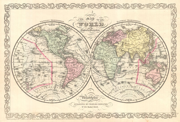
A New Map of the World on Globular Projection.
1856 (dated) 10.5 x 15 in (26.67 x 38.1 cm)
1856 (dated) 10.5 x 15 in (26.67 x 38.1 cm)
Description
A fine example of Charles Desilver's 1856 double hemisphere map of the World. Covers the entire world with color coding according to continents. The map shows recent discoveries in the Antarctic as well as the routes of various prominent explorers including Cook, Gore, and the U.S. Exploring Expedition. Desilver began issuing this map in 1856 when he acquired S. A. Mitchell's copyrights and printing plates. Desilver's changes to Mitchell's plates are largely limited to his addition of the grillwork border seen here. However, the most significant difference between the two publishers is Desilver's choice of a completely new color scheme, forgoing Mitchell's intense greens and blues for Colton's yellow and pink pastels. Issued as plate no. 1 in the 1856 edition of Desilver's New Universal Atlas.
Cartographer
Charles Desilver (1815 - May 18, 1876) was an American book and map publisher active during the 19th century in Philadelphia. Desilver, the son of Thomas Desilver of the firm Desilver, Thomas and Co., began is cartographic career as a partner in the firm Thomas, Cowperthwait and Company, the publisher of Samuel Augustus Mitchell's popular New Universal Atlas. Thomas, Cowperthwait and Company was succeeded by Cowperthwait, Desilver and Butler. In 1856, when the previous firm dissolved, Desilver succeeded it by starting his own lithographic firm, acquired Mitchell's copyrights, and began publishing his own variant on the New Universal Atlas. Desilver revised Mitchell's maps with a new grillwork border, his own color scheme, new titles, and some updated political data. Despite a noble pedigree, Desilver's maps did not sell well - possibly because they followed the long and very popular run of Mitchell's own atlases. Desliver continued to publish his atlas until 1859 (though we have heard that he also published an 1862 edition). In 1859 he resold the Mitchell copyrights and printing plates to S. A. Mitchell's son S. A. Mitchell, Jr. The younger Mitchell again updated the plates with his own border and color scheme. He began publishing his own successful atlas in 1860. Desilver continued to operate his firm even after selling the Mitchell copyrights, and his sons Harry and Joseph T., joined the firm in 1875 which was renamed Desilver and Sons. Desilver married Caroline Hill on March 29, 1836, in Philadelphia, with whom he had several children. More by this mapmaker...
Source
Desilver, C., A New Universal Atlas Containing Maps of the various Empires, Kingdoms, States and Republics Of The World., (Philadelphia) 1856.
Condition
Very good. Even overall toning. Blank on verso.
References
Rumsey 4557.003. Phillips (Atlases) 6135.