This item has been sold, but you can get on the Waitlist to be notified if another example becomes available, or purchase a digital scan.
1787 Samuel Dunn / Sayer Wall Map of the World in Hemispheres
World-dunn-1787$4,375.00

Title
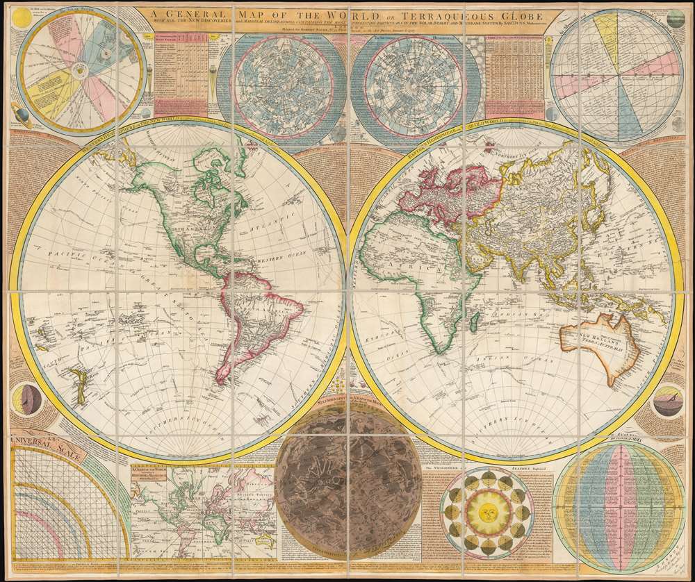
A General Map of the World, or Terraqueous Globe with all the New Discoveries and Marginal Delineations, Containing the Most Interesting Particulars in the Solar, Starry and Mundane System, by Sam. Dunn, Mathematician.
1787 (dated) 42.75 x 60 in (108.585 x 152.4 cm) 1 : 41000000
1787 (dated) 42.75 x 60 in (108.585 x 152.4 cm) 1 : 41000000
Description
An absolutely stunning and monumental double hemisphere wall map of the world by Samuel Dunn dating to 1794. This extraordinary map is so large and so rich in detail that it is exceptionally challenging to do it full justice in either photographic or textual descriptions. It covers the entire world in a double hemisphere projection. The primary map is surrounded on all sides but detailed scientific calculations and descriptions as well as northern and southern hemisphere star charts, a map of the Moon, a Latitude and Longitude Analemma chart, a map of the Solar System, a Mercator projection of the world, an Analemma projection, a seasonal chart, a universal scale chart, and numerous smaller diagrams depicting planets and mathematical systems. All text is in English.
We will start our survey of this map in North America, much of which was, even in 1794, largely unknown. This map follows shortly after the explorations of Captain Cook in the Arctic and Pacific Northwest, so the general outline of the continent is known. However, when this map was made, few inland expeditions had extended westward beyond the Mississippi. This map notes two separate speculative courses for the apocryphal River of the West, a northern route extending from Lake Winnipeg and a southern route passing south of Winnipeg through Pike's lake. The River of the West was hopeful dream of French and English explorers who were searching for a water passage through North America to the Pacific. In concept, should such a route be found, it would have become an important trade artery allowing the British and French, whose colonies dominated the eastern parts of North America, to compete with the Spanish for control of the lucrative Asia-Pacific trade. Little did these earlier speculative cartographers realize the bulk of the Rocky Mountains stood between them and their dreams!
Slightly south of the Rivers of the West, we find the kingdom of Quivira, which is one of the lands associated with Spanish legends of the Seven Cities of Gold. In this area we can also find Drake's Harbor or Port de la Bodega and Albion. Drake's Harbor is where Sir Francis Drake supposedly landed during his circumnavigation of the globe in 1580. Drake wintered in this harbor and used the abundant resources of the region to repair his ships. He also claimed the lands for England dubbing them New Albion. Although the true location of Drake's port is unknown, most place it much further to the north. By situating it and consequently New Albion further to the south, Dunn is advocating a British rather than Spanish claim to this region.
On the Eastern coast of North America we find a fledgling United States extending from Georgia to Maine. Dunn names Boston, New York, Charleston, Long Island, and Philadelphia, as well as the important smaller towns of Jamestown, Williamsburg and Edonton.
South America exhibits a typically accurate coastline and limited knowledge of the interior beyond Peru and the populated coastlands. A few islands are noted off the coast, including the Galapagos, which are referred to as the 'Inchanted Islands.' The Amazon is vague with many of its tributaries drawn in speculatively. Dunn and d'Anville have done away with the popular representation of Manoa or El Dorado in Guyana, but a vestigial Lake Parima is evident. Further south, the Laguna de los Xarayes, another apocryphal destination, is drawn at the northernmost terminus of the Paraguay River. The Xaraies, meaning 'Masters of the River' were an indigenous people occupying what are today parts of Brazil's Matte Grosso and the Pantanal. When Spanish and Portuguese explorers first navigated up the Paraguay River, as always in search of El Dorado, they encountered the vast Pantanal flood plain at the height of its annual inundation. Understandably misinterpreting the flood plain as a gigantic inland sea, they named it after the local inhabitants, the Xaraies. The Laguna de los Xarayes almost immediately began to appear on early maps of the region and, at the same time, almost immediately took on a legendary aspect as the gateway to El Dorado.
Across the Atlantic in Africa we find the situation in South America mirrored - that is, the coasts are well defined by the interior is vague. The Nile River follows the Ptolemaic course with a presumed source in two lakes at the base of the 'Mountains of the Moon.' Further east, the Niger River is well mapped but gets lost as it flows inland. There is no suggestion of its outlet into the Gulf of Guinea, which at the time had not been considered.
In the southern part of Africa we fine an elongated lake without a northern border labeled Massi. This is probably an embryonic form of Lake Malawi. Also in this area, we encounter the Kingdom of Monomatapa and the mountain range called the 'Backbone of the World.' This region of Africa held a particular fascination for Europeans since the Portuguese first encountered it in the 16th century. At the time, this area was a vast empire called Mutapa or Monomotapa that maintained an active trading network with faraway partners in India and Asia. As the Portuguese presence in the area increased in the 17th century, the Europeans began to note that Monomatapa was particularly rich in gold. They were also impressed with the numerous well-crafted stone structures, including the mysterious nearby ruins of Great Zimbabwe. This combination led many Europeans to believe that King Solomon's Mines, a sort of African El Dorado, must be hidden in this region. Monomotapa did in fact have rich gold mines in the 16th and 17th centuries, but most of these had been exhausted by the 1700s.
Asia is exceptionally well mapped reflecting the most recent information available in Europe - especially regarding the explorations of Vitus Bering and Tschirikow in the Siberian Arctic. Notes Macau, Formosa (Tay-oan), numerous silk route cities, the straits of Sin Capura (Singapore), Beijing (Peking), Edo (Tokyo) and Bombay.
Australia appears in full as New Holland or Terra Australis. Names numerous points along the coast with associated notes regarding the activities of various explorers. Van Diemen's Land or Tasmania is curiously attached to the mainland - an error that many earlier maps had long ago corrected. Further east New Zealand is exceptionally well formed. Most of the region has been thoroughly mapped by Cook, though several of the cartographic errors perpetuated by Quiros are present. There is little trace of either Antarctica or the Great Southern continent, though Bouvet's Island does appear as 'Sandwich Land.'
Throughout the map we can also find the routes of numerous important explorers including Middleton, Anson, Bougainville, Cook, the Resolution, the Spanish Galleon Carlos, Bouvet, and others. Often their landings and important discoveries are also noted.
Drawn in London by Thomas Dunn based on earlier cartographic research by J. B. B. D'Anville. Published by Laurie and Whittle as plate nos. 1-2 in the 1797 edition of Thomas Kitchin's General Atlas.
CartographerS
Samuel Dunn (1723 - January 1794) was a teacher of mathematics, navigation, and astronomy, an engraver, and a publisher active in London, England, during the second half of the 18th century. Dunn was born in Crediton, Devonshire, England. He was active as a teacher of navigation, running his own school, as early as 1742, when he was just 19. In 1758 Dunn became master of an academy at Ormond House, Paradise Row, Chelsea, London. He is credited with observing the transit of a comet in January of 1760 and the thrust of Venus in 1761. Dunn was a member of the Commission for the Discovery of the Longitude at Sea. As such he was one of the few teachers appointed to issued ship masters with 'Certificates of Competence' for the Board of Longitude. Dunn was also an official teacher of navigation for the East India Company and succeeded William Herbert as the editor of the New Directory for the East Indies. He published a number of scientific and astronomical texts as well as several important maps and charts. He lived until his death at No. 1 Boar's Head Court, Fleet Street, London, England. More by this mapmaker...
Robert Sayer (1725 - January 29, 1794) was an important English map publisher and engraver active from the mid to late 18th century. Sayer was born in Sunderland, England, in 1725. He may have clerked as a young man with the Bank of England, but this is unclear. His brother, James Sayer, married Mary Overton, daughter-in-law of John Overton and widow of Philip Overton. Sayer initially worked under Mary Overton, but by December of 1748 was managing the Overton enterprise and gradually took it over, transitioning the plates to his own name. When Thomas Jefferys went bankrupt in 1766, Sayer offered financial assistance to help him stay in business and, in this way, acquired rights to many of the important Jefferys map plates as well as his unpublished research. From about 1774, he began publishing with his apprentice, John Bennett (fl. 1770 - 1784), as Sayer and Bennett, but the partnership was not formalized until 1777. Bennett retired in 1784 following a mental collapse and the imprint reverted to Robert Sayer. From 1790, Sayer added Robert Laurie and James Whittle to his enterprise, renaming the firm Robert Sayer and Company. Ultimately, Laurie and Whittle partnered to take over his firm. Sayer retired to Bath, where, after a long illness, he died. During most of his career, Sayer was based at 53 Fleet Street, London. His work is particularly significant for its publication of many British maps relating to the American Revolutionary War. Unlike many map makers of his generation, Sayer was a good businessman and left a personal fortune and great estate to his son, James Sayer, who never worked in the publishing business. Learn More...
Condition
Very good condition. Dissected and mounted on linen.
References
Rumsey 2310.002, 2310.003, 0411.001, 0411.002, 0411.003, 2310.004. Phillips (Atlases) 4300. National Maritime Museum, 375 (3rd ed. 1801). National Library of Australia, Map Collection, 3258045. New York Public Library, Slaughter Collectoin, Slaughter 1035R; Map Division, Map Div. 02-322.